Magnitude 5.3 Earthquake Near Salcha Rattles Interior Alaska
Elisabeth Nadin
Natalia Ruppert

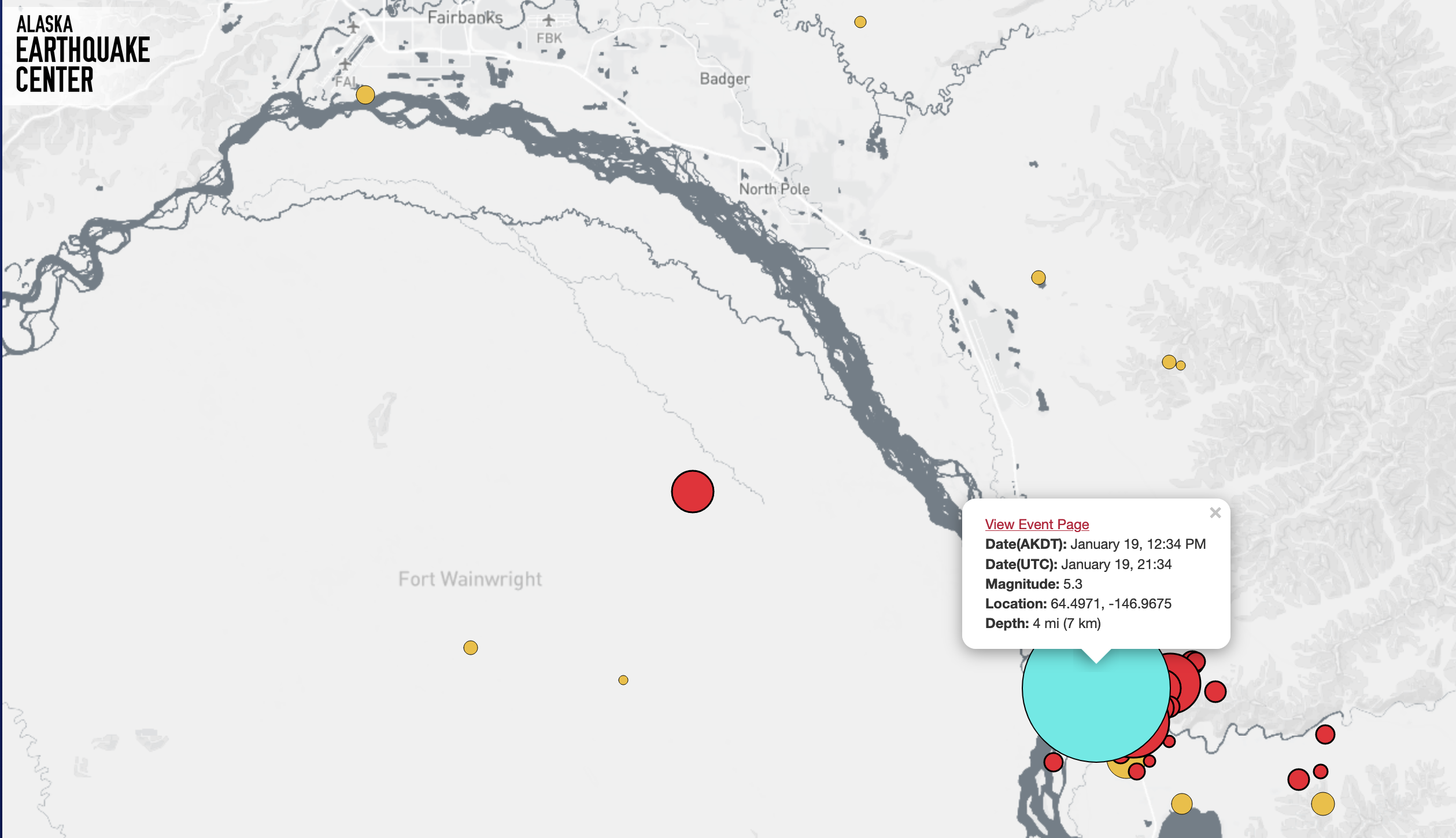
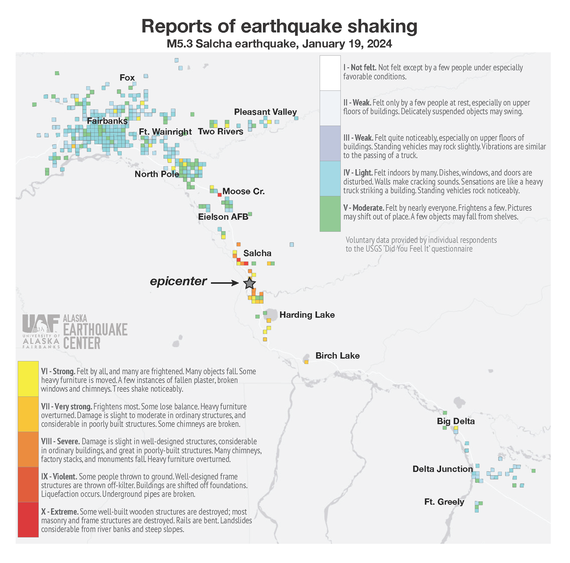
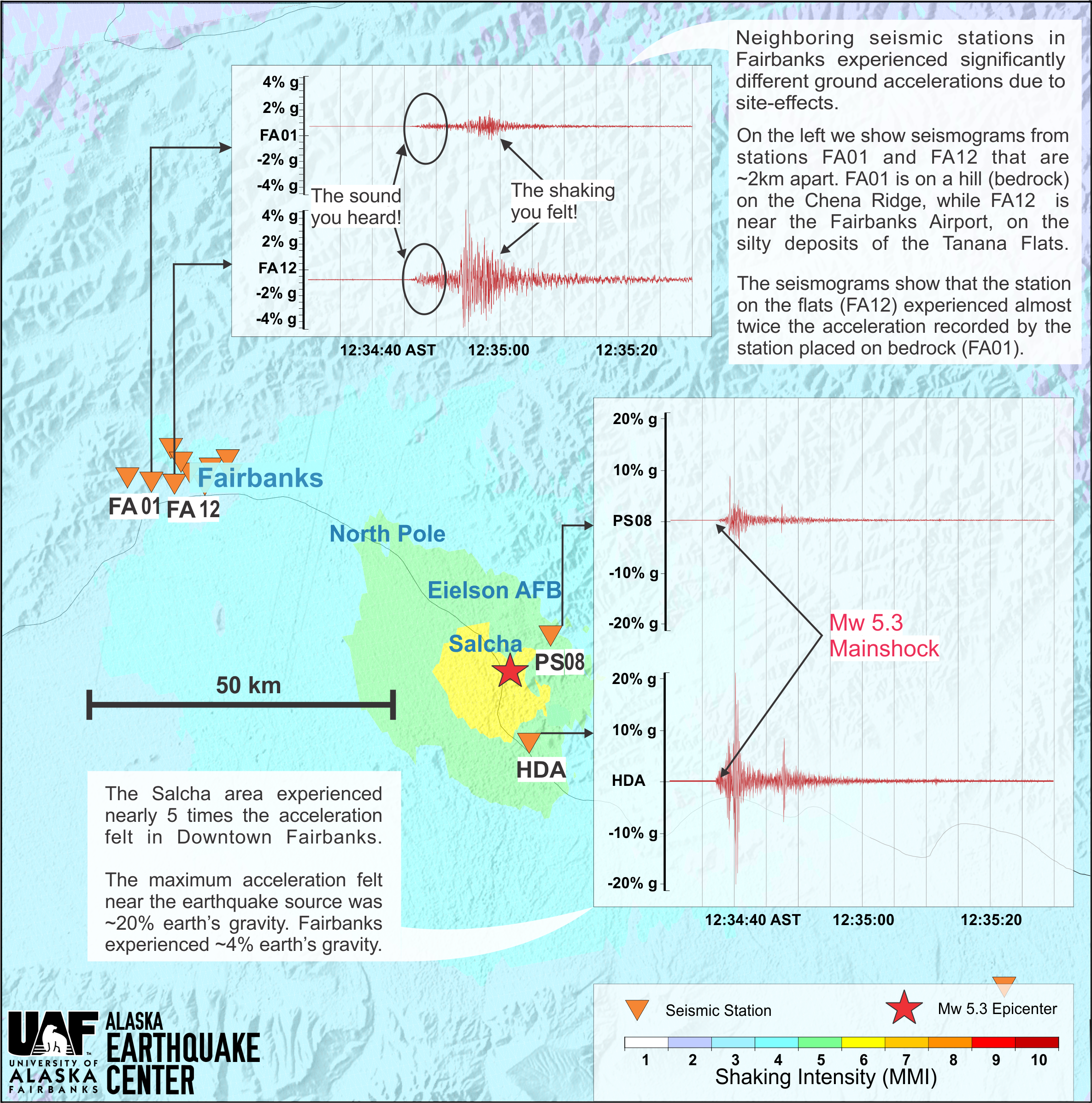
The Alaska Earthquake Center was in the midst of giving a tour to a group of international Arctic Weather Workshop attendees when suddenly, the ground started to shake. When it continued to shake, everyone realized this was more than just a truck rumbling by. A magnitude 5.3 earthquake struck under Salcha, a small community about 30 miles (50 km) southeast of Fairbanks (Figure 1). The event was shallow, at 4 miles (7 km) deep, which means it was felt more intensely than if it was deeper in Earth’s crust.

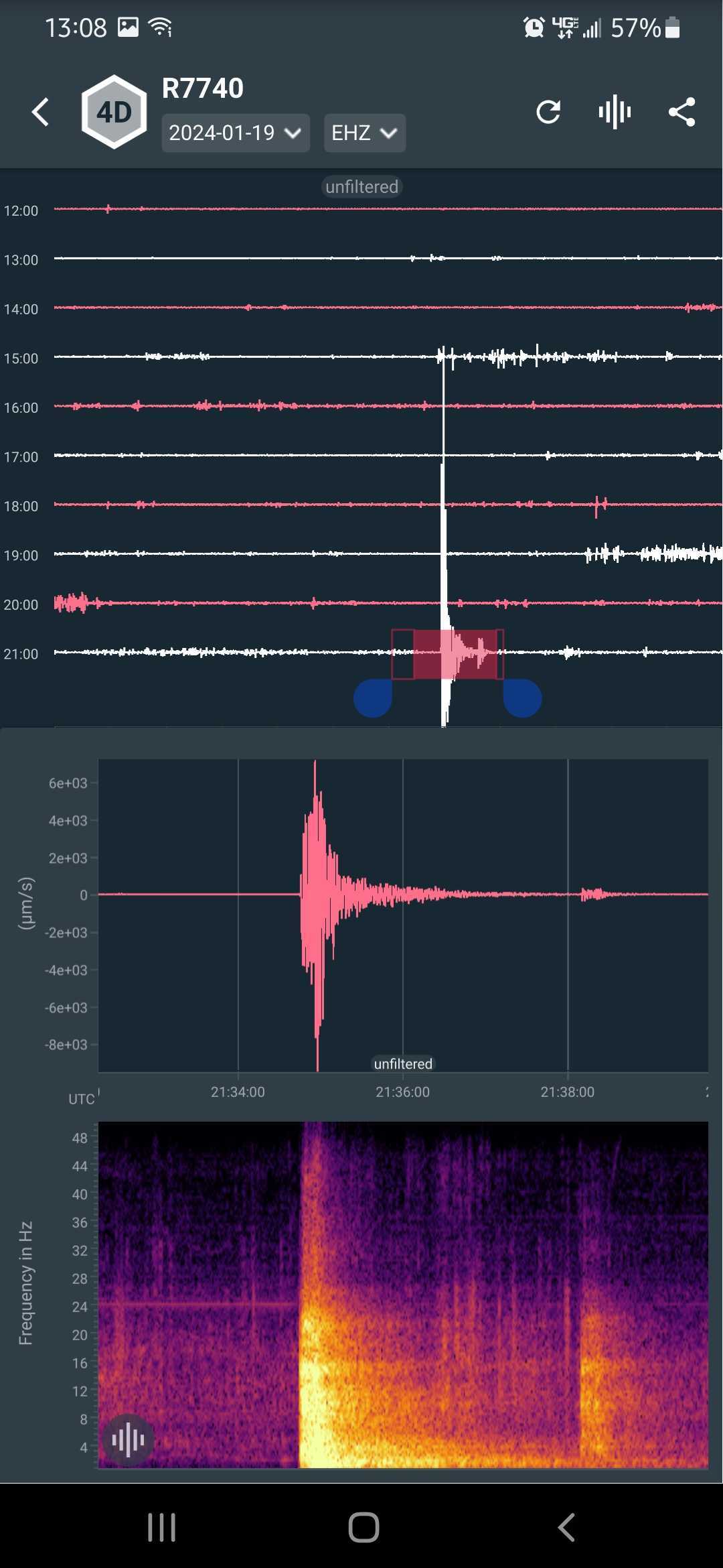
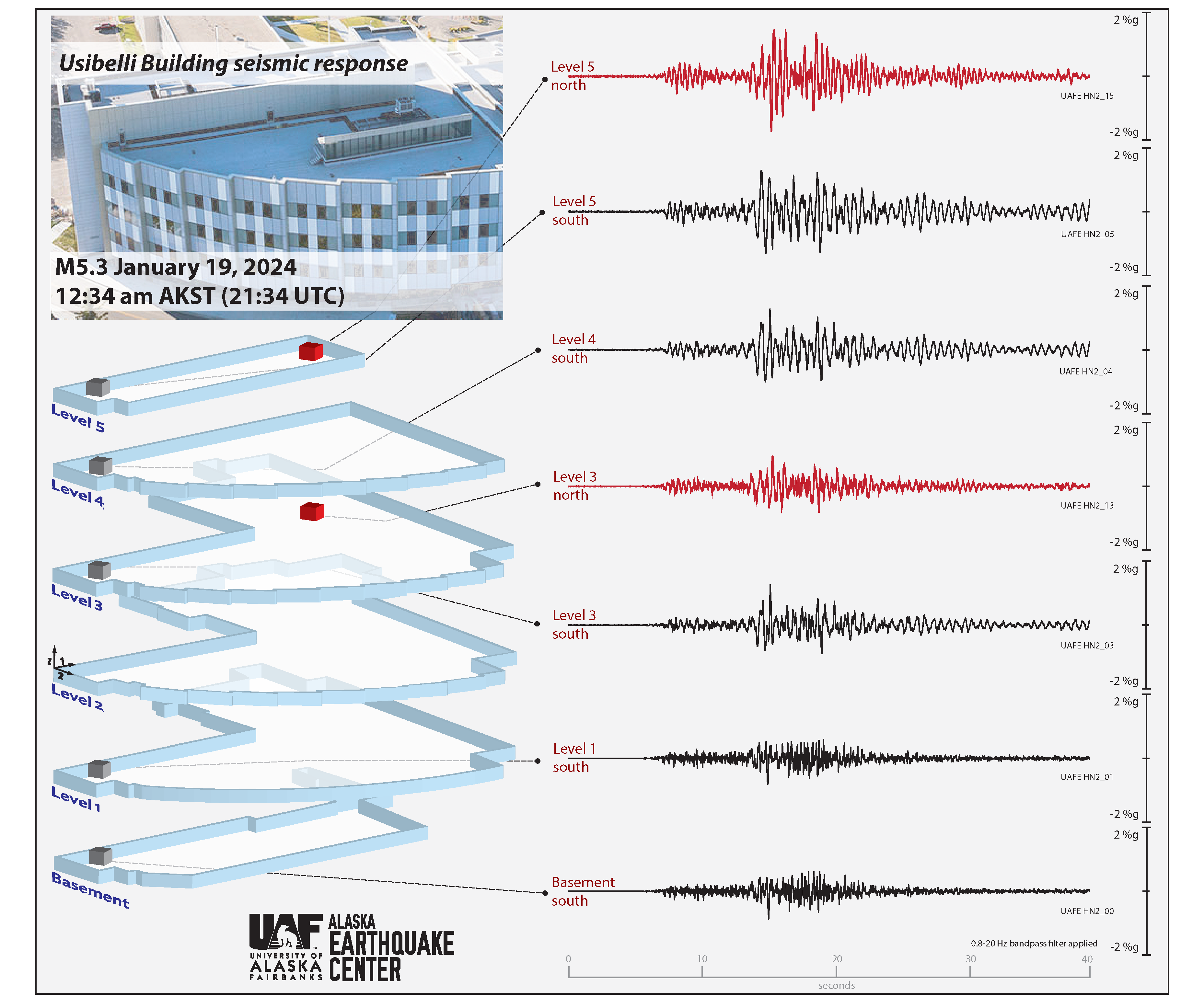
The earthquake proceeded in typical earthquake fashion—gentle rumbling that grew into more significant shaking, along with some rolling (Figure 2). Office computers swayed on the desks. The shaking lasted for 5–10 seconds, after which everyone looked at each other, startled, and then several people on the tour exclaimed that it was the first earthquake they had ever felt.

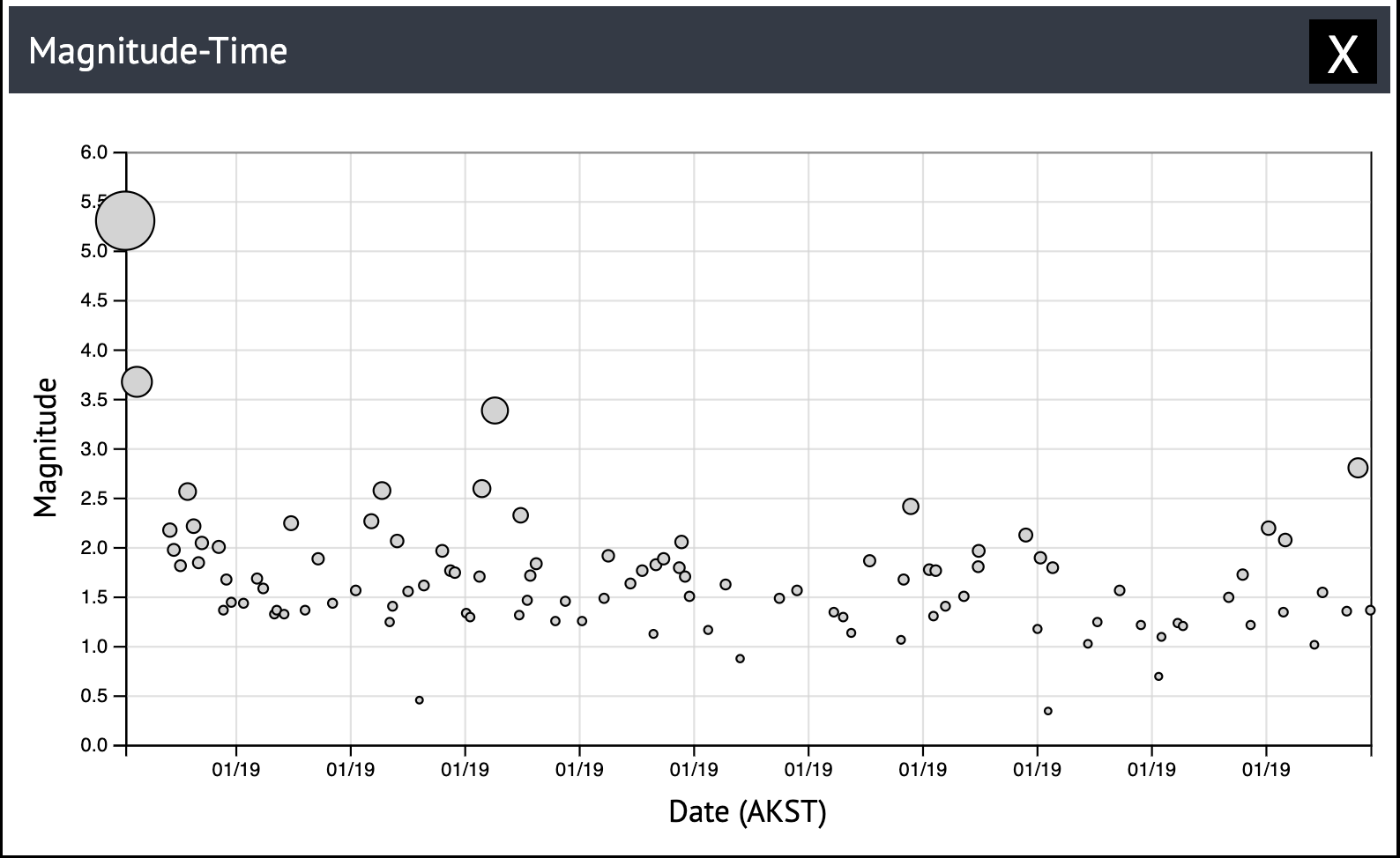
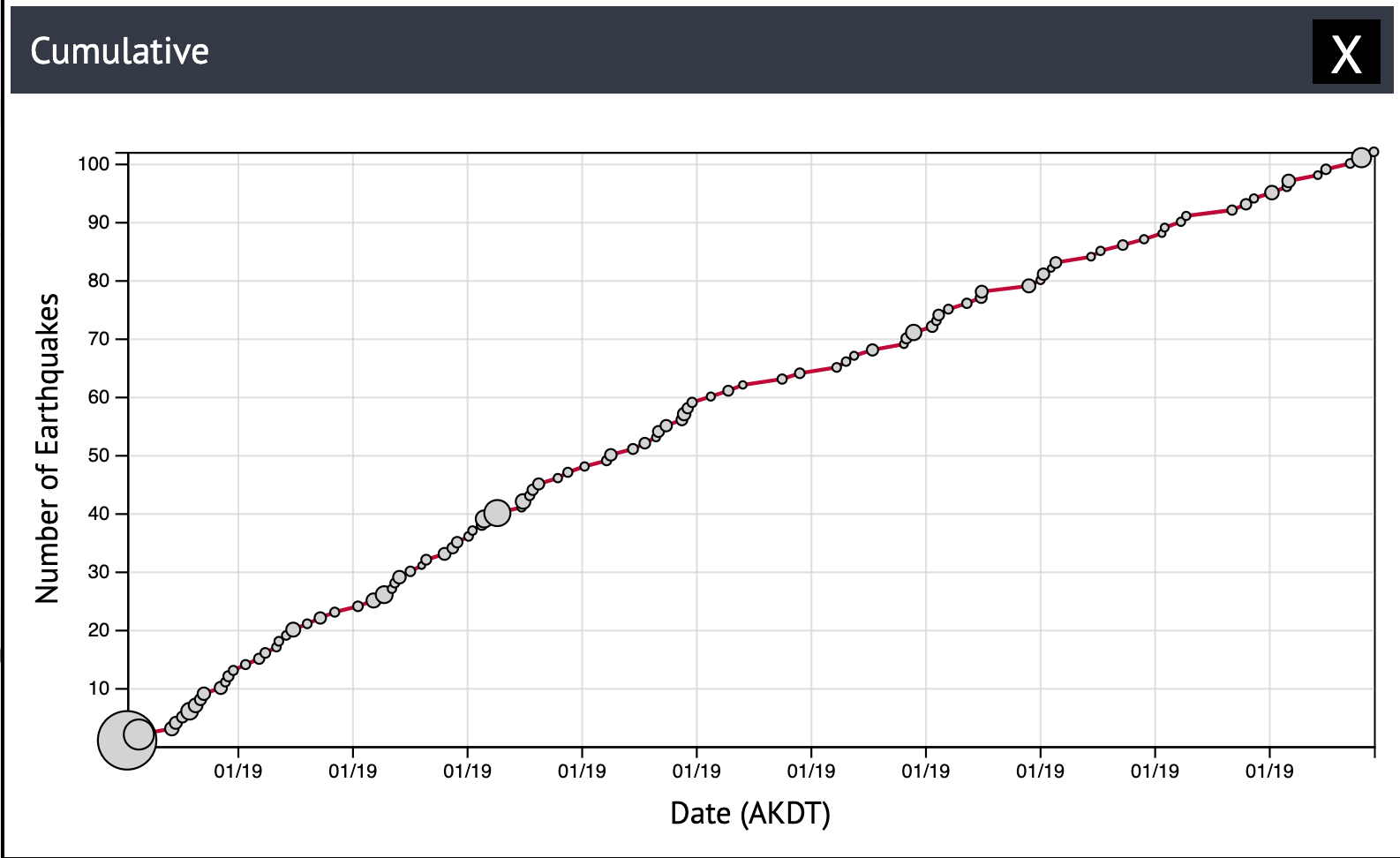
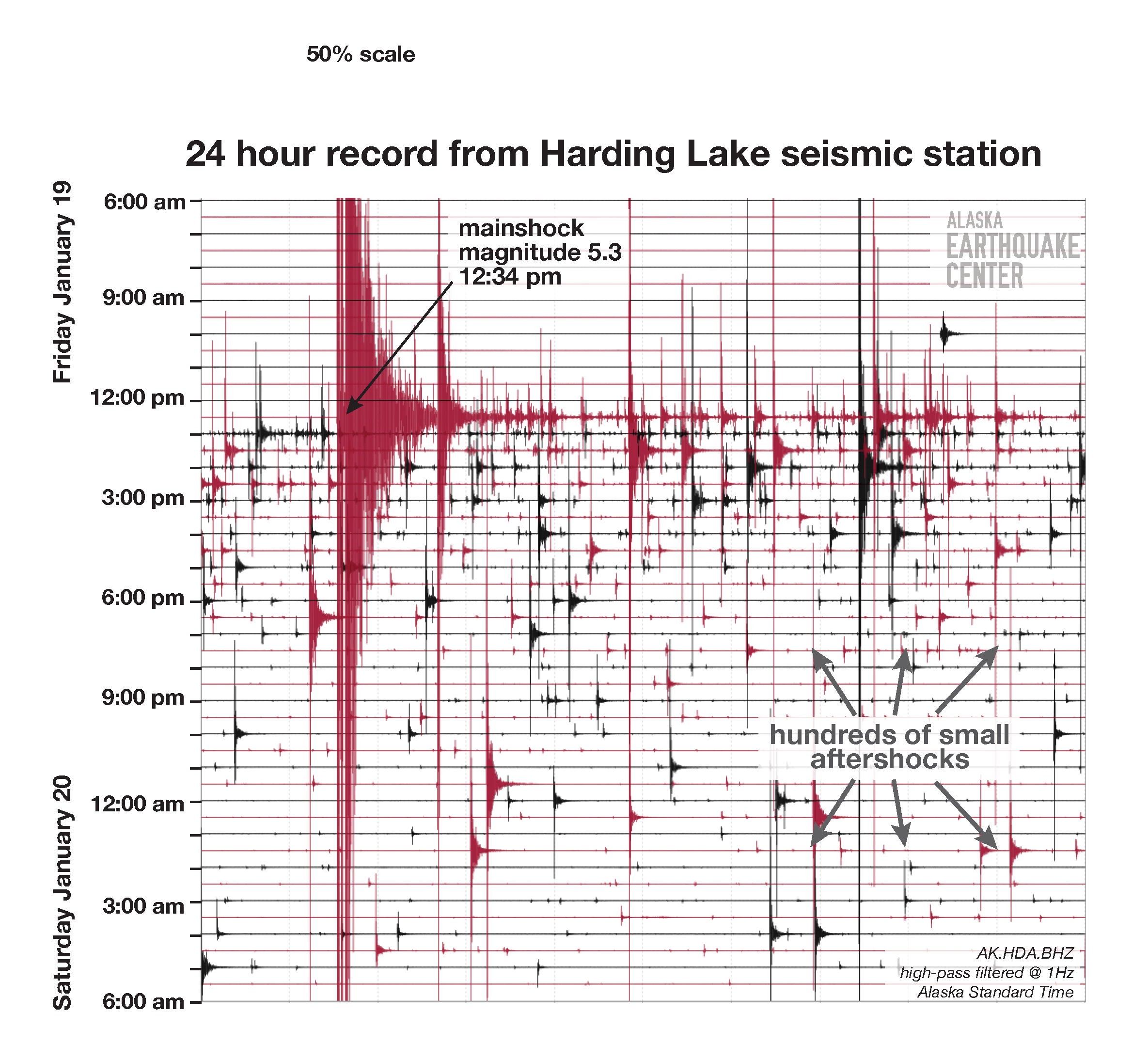
Residents who called the Alaska Earthquake Center reported near-continuous shaking for more than an hour after the mainshock (Figure 3). Indeed, more than 50 aftershocks had been recorded within three hours (Figure 4), and most were less than 10 miles (16 km) deep.

Earthquakes in this region are common, but the M5.3 event was significant, and in fact resulted in the strongest shaking felt in the area in the past decade. A seismic station near Harding Lake recorded ground shaking at 21 percent of gravity (21 %g), which is twice the shaking of the M4.9 on September 14, 2021. Another notable earthquake happened in the region just a few months prior, a M4.7 on July 22. The largest earthquake recorded in the area was a magnitude 7.1, on July 22, 1937. The University of Alaska Museum of the North ShAKe virtual exhibit contains newspaper clippings, photos, interviews and more, including those from the 1937 M7.1 Salcha earthquake.

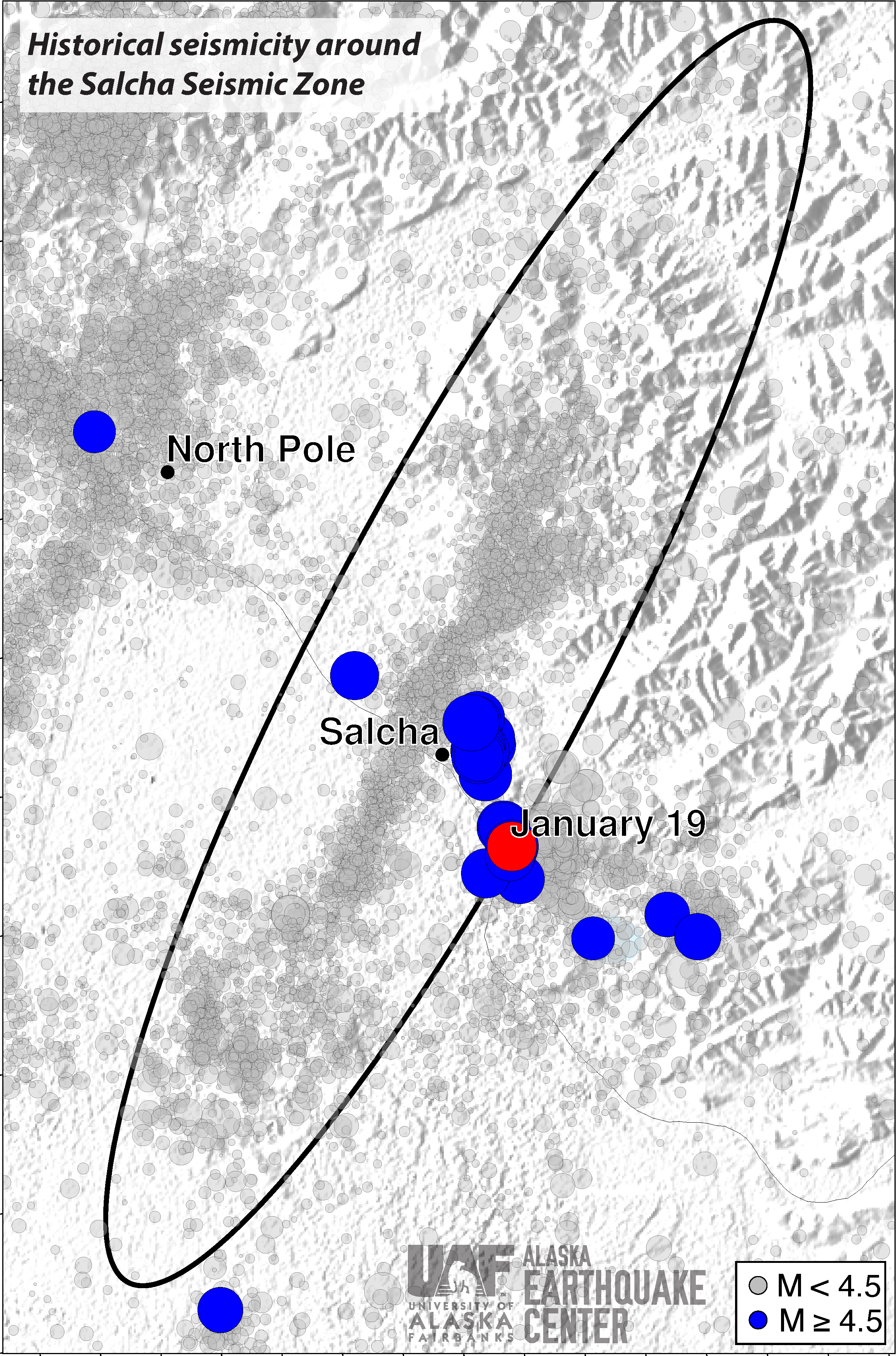
The Salcha seismic zone is an earthquake-riddled NNE-trending lineament, which defines  a fault that has no expressed surface rupture. The fault zone stretches from the northern foothills of the Alaska Range towards Salcha. This zone parallels the Fairbanks and Minto Seismic Zones to the west. Combined, these fault zones produce thousands of earthquakes each year. These broad, linear fault structures are believed to exist because the region is bordered by the Denali fault to the south and the Tintina fault to the north, causing the crustal blocks in between to rotate clockwise.

Figures 6-9 show more in-depth analysis of this earthquake.

Map showing location of magnitude 5.3 earthquake.
Figure 1. Location of the January 19, magnitude 5.3 Salcha earthquake. 


Small seismometer shows the strong shaking in Fairbanks.
Figure 2. Screen shot of a Raspberry Shake seismometer, located on the east side of Fairbanks, that recorded the Salcha magnitude 5.3 earthquake on January 19, 2024. Image courtesy of Gabe Paris, Alaska Earthquake Center.


The two largest aftershocks so far were around magnitude 3.5.
Figure 3. The magnitude of aftershocks over time, until 7pm on January 19, from the M5.3 earthquake, showing the two largest aftershocks so far were around magnitude 3.5.


Aftershocks occurred frequently at first, then began occurring more infrequently.
Figure 4. The cumulative number of aftershocks over time, until 7pm on January 19, shows there were many aftershocks initially, then gradually occurring more infrequently. 


Long crack in concrete floor.
Figure 5. Photo of a crack in a poured-concrete garage floor that resulted from the earthquake, in a home very close to the earthquake epicenter. Courtesy of Salcha resident Amy Peters.


The higher floors of the building show more shaking than the lower floors.
Figure 6. This figure shows the seismic response of the UAF Joseph E. Usibelli Engineering Learning and Innovation Building to the January 19 magnitude 5.3 Salcha Earthquake. Instrumentation in the Usibelli building captured the strongest shaking on the upper floors, a common phenomenon in multistory structures during seismic events. The varied response within the building's structure, with lower floors reflecting the earth’s motion and higher floors amplifying it, underscores the importance of engineering solutions such as seismic counterweights, especially in skyscrapers within earthquake-prone areas.


The most shaking was reported felt near Salcha.
Figure 7. The shaking that people experience during an earthquake can be measured on the “Mercalli Intensity” scale. This is different than magnitude because it diminishes as you move away from the epicenter. In the Fairbanks and Delta areas, people reported intensities IV-V. Closer to the earthquake, people reported VI-VII. This agrees with data recorded on nearby seismic stations. There are scatter and outliers in the data because people react differently to shaking. When averaged across a lot of responses however, these are meaningful data. In the Anchorage and Kenai areas, people reported shaking of II - III. Before the mid-20th century, mail-in versions of these questionnaires were sometimes the primary data used to estimate the size and location of an earthquake.


Seismic record from the Harding Lake station shows the mainshock and almost continuous aftershocks.
Figure 8. This figure shows 24 hours of data from a seismic monitoring station a couple miles west of Harding Lake, beginning Friday morning. The station was quiet in the hours before the earthquake. The M5.3 mainshock occurred at 12:34pm and was followed by near-constant aftershocks for the first hour. Over the next day, the rate of aftershocks began to diminish. We anticipate these aftershocks will continue to become less frequent in the coming days. However, sometimes an earthquake like this can be followed days to weeks later by another one. An M4.7 earthquake in nearly the same location in 2021 was followed two months later by an M4.9 earthquake.


Small earthquakes delineate faults in Interior Alaska seismic zones.
Figure 9. This figure shows historic seismicity around the Salcha Seismic Zone (black oval). Earthquakes that have magnitude greater or equal to 4.5 are highlighted in blue, and the mainshock on the morning of January 19 is highlighted in red. We refer to this as a "seismic zone" because of the persistent occurrence of small and moderate earthquakes. Though these earthquakes clearly delineate a fault system, this and many others in the Interior do not have obvious features that can be mapped on the surface of the Earth.


Salcha experienced nearly 5 times the ground accelleration as downtown Fairbanks.
Figure 10. This figure illustrates the differences in ground acceleration recorded near the earthquake source (Salcha region) and those observed in Fairbanks city. Fairbanks experienced accelerations as high as ~4% of earth’s gravity (g), while the Salcha region recorded nearly 5 times this value. The figure also highlights the variations in ground acceleration caused by site-effects despite being recorded at neighboring seismic stations (e.g., FA01 and FA12 ~2 km apart). The public reported a rumbling sound prior to the shaking. This separation between the arrival of the compressional (acoustic) waves and the surface waves (shaking) can clearly be seen in the acceleration data recorded by the seismic stations.