
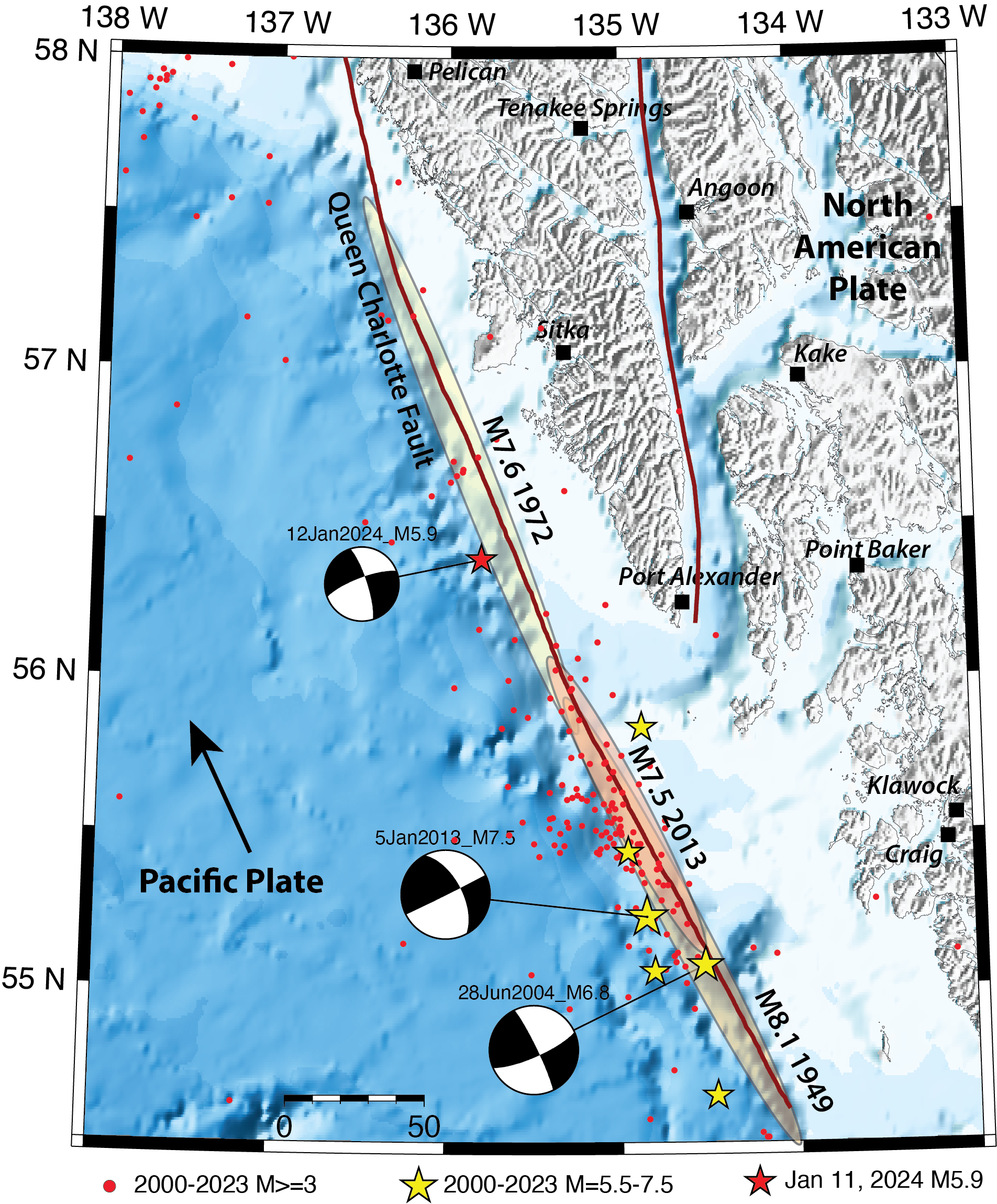


A magnitude 5.9 earthquake shook southeastern Alaska at 10:46 p.m. local time on Thursday, January 11, 2024 (January 12, 7:46 UTC). Situated 45 miles northwest of Port Alexander, the nearest population center, it was reported as felt by almost 600 people in southeastern Alaska and northern British Columbia. The intensities of shaking were weak to light. The largest earthquake in Alaska so far this year, it is also the largest in the region in a decade. It is located 88 miles (142 km) north of the M7.5 earthquake of January 5, 2013.
Earthquakes in southeast Alaska typically have shallow depths of less than 15 miles (25 km), and are generally located along the Queen Charlotte and Fairweather Faults. These faults are part of a system that forms the transform boundary between the Pacific and North American plates.
The M5.9 earthquake occurred on the Queen Charlotte fault system. Its estimated source mechanism is consistent with right-lateral slip on a northwest-striking fault, which is expected from the tectonic setting of the earthquake.
Strike-slip faults, even of large magnitude, typically don’t generate tsunamis because their displacement is horizontal. However, it is possible for a significant strike-slip event in coastal Alaska to trigger local landslides, which can certainly cause a tsunami. The 1958 M7.9 Lituya Bay earthquake, which led to the largest tsunami in Alaska’s history, was on the Fairweather fault and about 150 miles north of the January 11 event. The tsunami was caused by a rockslide shaken loose by the earthquake. Light shaking, like the type produced by the January 11 M5.9 event, would not have triggered a tsunami warning.
In the past, the entire length of the combined Queen Charlotte–Fairweather faults has ruptured in strike‐slip earthquakes greater than magnitude 7. The largest event, a M8.1 on August 22, 1949, began in British Columbia and ruptured both southward and northward for a total rupture length of about 310 miles (500 km), crossing the border with Alaska. Overall, six earthquakes of magnitude 5.5 or larger occurred in the past 25 years along the Queen Charlotte fault in southeast Alaska. The January 11th event has the northernmost location, but also lies within a portion of the fault that ruptured in a M7.6 earthquake in 1972.
So far, we have not reported any aftershocks from the earthquake, but they are to be expected for an event of this size. The U.S. Geological Survey has an automated aftershock forecast, and projects an almost 80 percent chance that in the next month, people in the area will feel the light shaking associated with a magnitude 3 or above.