


For Elena Suleimani, studying all kinds of waves for her Bachelor’s degree in radiophysics and electronics at Gorky State University, Russia, led to making waves as a career—studying tsunami hazards in Alaska.
Elena’s fascination with mathematics and coding drove her master’s research at the University of Alaska Fairbanks Institute of Marine Sciences. She focused on creating equations for a mathematical model of the 1883 tsunami caused by the eruption of Augustine Volcano in Cook Inlet. She then compared the model to real-world observations “to demonstrate that the model worked.”
In 1996 her thesis defense “was the first multimedia defense at the Geophysical Institute,” Elena recalls. She used the Geophysical Institute’s supercomputer to create an animated visualization of her model. Working with staff in the computing department, she recorded the animations on a VHS tape for her thesis presentation. “The amount of work that went into that short animation was insane, it was very labor intensive.”
This simulation shows Elena Suleimani’s mathematical model of the tsunami caused by Augustine Volcano’s eruption in 1883.
As an international student, Elena had about a month after her defense to find a job before her visa expired. “So I printed my resume and started at the seventh floor of the Geophysical Institute and took my resume office to office.” Professor Craig Lingle from the Snow, Ice, and Permafrost department called the next day. He needed a numerical modeler to study dynamics of the Antarctic ice sheet. “The equations were slightly different, so he gave me a crash course on ice physics.” They eventually published several papers together.
In 1998 Roger Hansen, the director of the Alaska Earthquake Information Center (as it was named then), received good news. The National Tsunami Hazard Mitigation Project awarded UAF a grant for tsunami modeling—but he needed someone who could do that. “He learned there was someone at UAF who could do tsunami modeling, and then basically told me I was moving down to the third floor to do tsunami work. I started making tsunami inundation maps for coastal communities in Alaska,” Elena recalls.
Those first maps grew into more than two decades of tsunami work, including earning a Ph.D. in Geophysics from UAF in 2011. Elena’s Ph.D. research focused on modeling tectonic and landslide tsunamis of the magnitude 9.2 1964 Great Alaska Earthquake.
Over the years, the funding for the inundation mapping project has become stable, supporting important tsunami hazard mapping for communities (visit tsunami.alaska.edu) and outreach in Alaska. There are currently more than 30 published inundation reports covering nearly 60 Alaska communities, along with other community-focused materials. In addition to tsunami modeling, Elena gives community presentations, including high school science classes, to share information about tsunami hazards and preparedness.
In 2011 the Tohoku Earthquake offshore of Japan had an unexpected tsunami generation mechanism, creating a far more damaging tsunami than anticipated. It also upended how tsunami scientists estimated hazards. “Since 2011 we have to look at the tsunami scenarios differently, although the equations stay the same. Now that we know more, we can update our models,” Elena says.
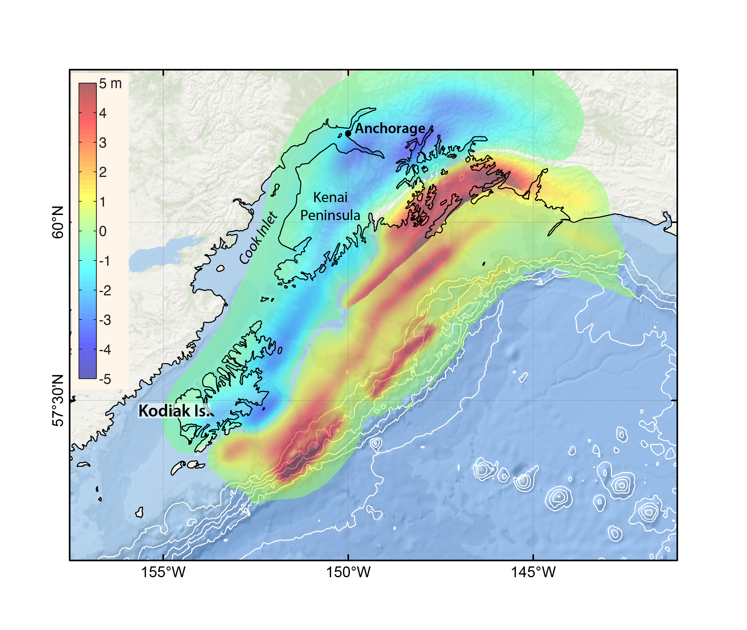
“We do our best to account for inundation. We use our imaginations when setting scenarios to model,” Elena says. For example, the 1964 Great Alaska Earthquake caused uplift of the ocean floor in the Gulf of Alaska, which created a tsunami. The uplift wasn’t the same across the 500 mile (800 km) rupture length, it happened in patches (see Figure 1). “Previous historical earthquakes in the region show uplift patches happening in different locations than in 1964. Anchorage did not experience tsunami damage in the 1964 earthquake, because little tsunami energy propagated into Cook Inlet due to specific locations of those patches. But what if an uplift patch occurred right at the entrance to Cook Inlet, causing a tsunami with nothing blocking it from Anchorage? Those are the kinds of scenarios we consider.”
What does Elena enjoy about this job? “I like writing codes and analyzing modeling results. When we did benchmarking of our tsunami model (in 2004 the NTHMP required validation of all models used for production of tsunami maps in the U.S.), it was a lot of that type of work.” Connecting communities with the technical information is also important. “I enjoy bringing that knowledge to communities, using normal words to explain the hazards.”
Elena explained the right attitude about tsunami hazard modeling is crucial: “We need to be humble, because the next time a major tsunami happens, there will be some other mind-blowing thing we learn.”