


This evening’s M7.8 earthquake [7/21/20, 10:12 PM AKDT] occurred on the well-known subduction zone interface off the Alaska Peninsula. Strong shaking has been reported from Perryville and Sand Point to King Cove and Cold Bay. Weak shaking was felt more than 500 miles away in the MatSu and Anchorage areas. At this time we are not aware of significant damage caused by the shaking, and the National Tsunami Warning Center has called off its various warnings. However, this story will surely continue to unfold as we learn more.
Several people have noted that this earthquake is the same size as the earthquake just a couple of years ago off the coast of Kodiak. It too led to well-warranted tsunami warnings, though the style of the earthquake was quite different. Other folks have asked how this compares to the 2018 Anchorage earthquake. A good point of comparison is that tonight’s earthquake released roughly 15 times more energy than the Anchorage earthquake. Why was the Anchorage quake so much more damaging? Location, location, location.
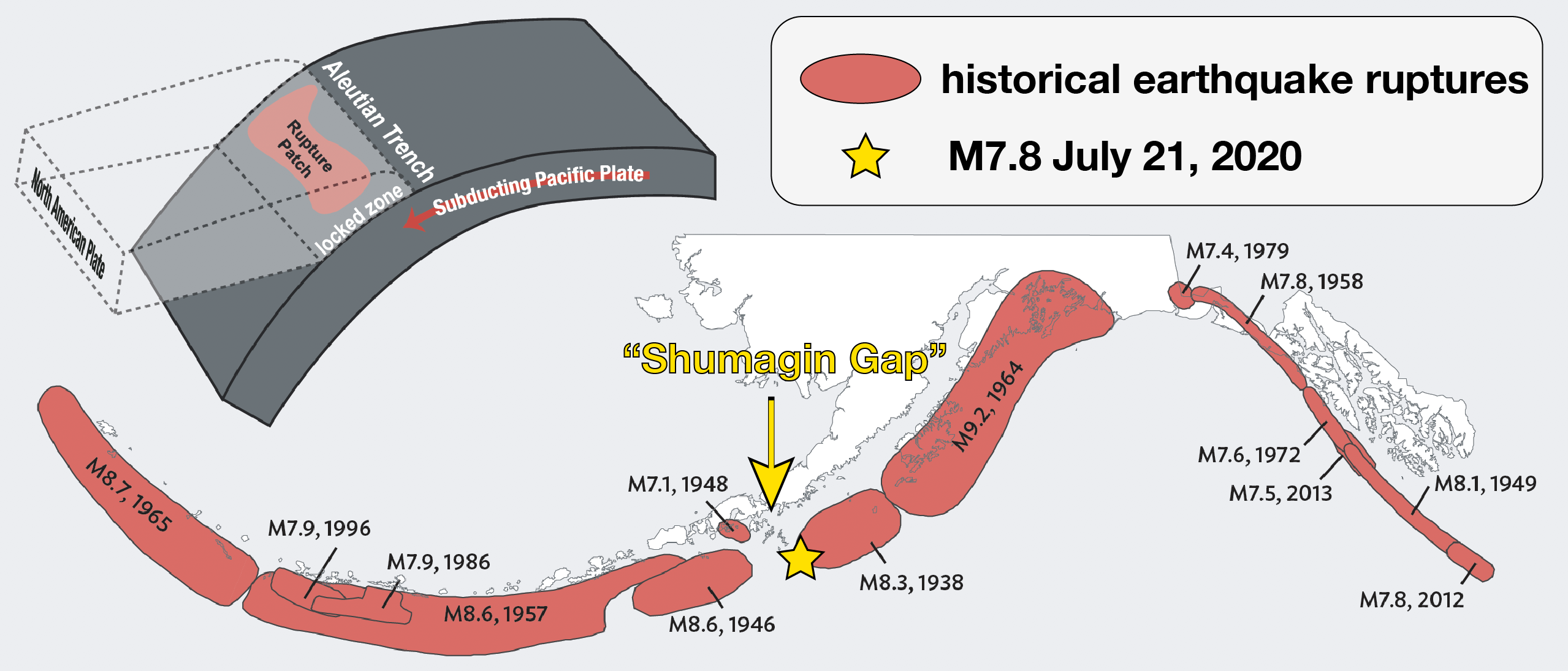
Tonight’s earthquake occurred for well-understood reasons. As the Pacific Tectonic Plate creeps northward at a couple of inches per year it is slowly forced beneath the North American Plate. These plates typically lock together and rupture on occasion in large earthquakes such as this. When an earthquake occurs, it ruptures a ‘patch’ of this fault that can be 10s to 100s of miles long (see the inset cartoon on the top left). Early evidence suggests that this earthquake ruptured a patch that is up to 100 miles or so in length.
Though this style of earthquake is quite common, the specific location will generate a lot of scientific interest. The map figure shows the ruptures of major subduction zone earthquakes over much of the past century. What it shows is that essentially all of the subduction zone has ruptured at some point—except for the region near the Shumagin Islands. For this region, the so-called ‘Shumagin Gap’ has been a focus of study since the 1970s. Scientists have long argued about whether this gap is overdue for a large earthquake, or whether it might be immune because the plates slid quietly without locking. This recent post summarizes the debate well. The epicenter of tonight’s earthquake is right on the edge of the 1938 earthquake. Very preliminary aftershock solutions suggest that the earthquake may have ruptured westward into the Shumagin Gap. This could be premature and it will take a few days to get a clearer picture. Either way, this earthquake is sure to stir considerable debate and bring even more attention to this enigmatic region of the subduction zone.
As we learn more, we will be compiling relevant observations and links to other resources on the main page for this earthquake. I encourage you check in and see how our understanding evolves.
I would also like to put out a call to folks in communities nearest to the quake. We are interested in hearing your observations and what you experienced related to either the earthquake or the modest tsunami. You can reach us on Twitter, Facebook, or email (uaf-aec@alaska.edu).
I am glad everyone seems safe. Good night.