July marks the anniversary of Alaska’s most notorious landslide, Lituya Bay (1958), which generated a devastating tsunami.
A new look at the Alaska Earthquake Center's roots
The Alaska Earthquake Center formally started in 1987, but our roots go back much further than that.
The case for a landslide monitoring program
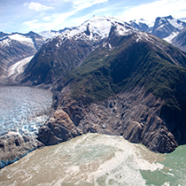
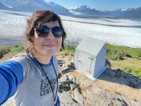
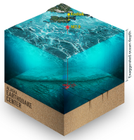
On the evening of Aug. 9, 2025, passengers on the Hanse Explorer finished taking selfies and videos of the South Sawyer Glacier, and the ship headed back down the fjord.
Seismic record analysis can reveal a glacier’s past
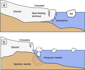
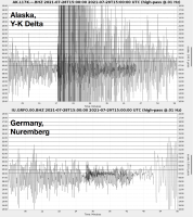
The history of earthquake-like signals created by the crashing of glacial ice into the ocean can reveal how a glacier has changed over time, according to research by a University of Alaska Fairbanks team.
Miles, fixes, and progress in the 2025 Field Season
As Interior Alaska remains in a deep freeze, the Alaska Earthquake Center field team is busy planning for the upcoming season.
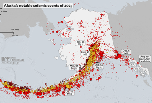
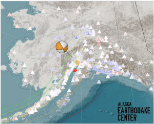
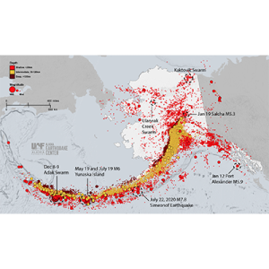
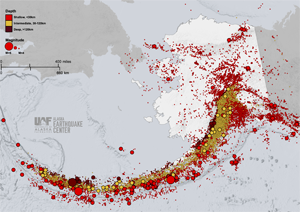
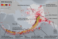
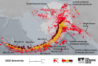
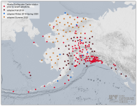
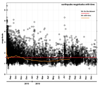
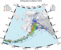
2025 Seismicity Year in Review
As we slide into spring here in Alaska, memories of last year’s earthquakes and other remarkable seismic events are probably fading fast.
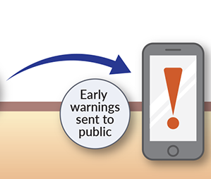
New funding advances earthquake early warning for Alaska
Alaskans are closer to having critical seconds of warning that shaking from a major earthquake is about to occur.
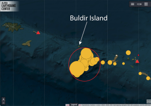
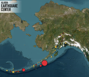
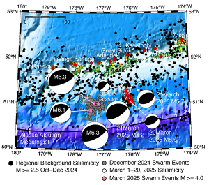
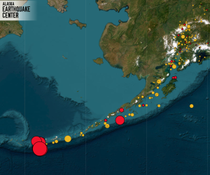
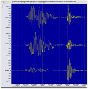
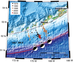
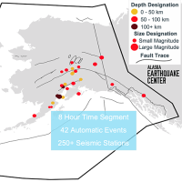
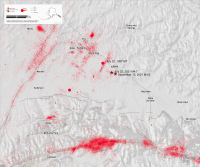
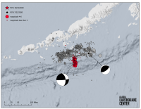
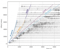
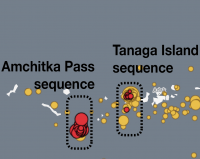
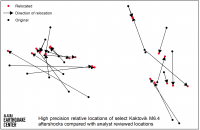
A Mysterious Earthquake Sequence Near Buldir Island
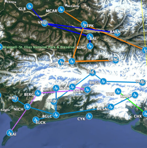
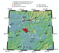
On March 4 at 8:54 a.m., a magnitude 6.4 earthquake struck the western Aleutian Islands, about 42 miles south of Buldir Island (Figure 1).
A surprise twist in the quest for landslide warning signs
Gabrielle Davy’s graduate research, now published in a scientific paper, started out looking for seismic signals that were precursors t
Testing an array setup for earthquake early warning
KODIAK ISLAND, Alaska — Alders, alders, everywhere.
When you follow scientists in the Alaska wilderness, you’ll almost certainly get alder-snagged.
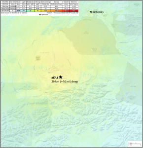
December 6 Magnitude 7 Near the Canadian Border
On Saturday, December 6, just before noon, a magnitude 7 earthquake was felt across a 500-mile radius around the epicenter, near Hubbard
Magnitude 6 Susitna Earthquake Shakes Up Thanksgiving
A magnitude 6.0 earthquake beneath Susitna, Alaska, was felt by thousands of Alaskans at about 8:12 am on Thanksgiving morning.
A Complete Overhaul—Under the Hood
You might not notice as you browse through our interactive map and events list, but the Alaska Earthquake Center has completely rebuilt the engine that drives this information.
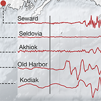
A Mid-Morning Quake Between Seward and Homer
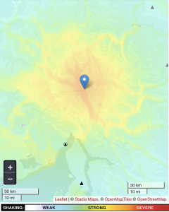
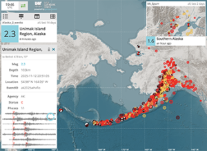
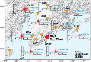
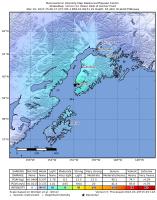
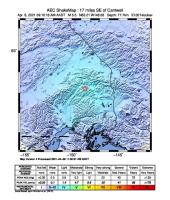
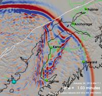
A magnitude 5.4 earthquake south of Seward (Figure 1) at around 9:30 am on October 30, 2025 was reported as felt for about 100 miles (165 km) around the epicenter.
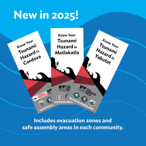
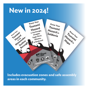
New Tsunami brochures for Cordova, Metlakatla, and Yakutat
Coastal Alaska communities live with the most serious tsunami risk in the United States.
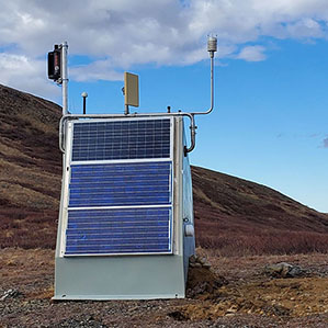
Station comeback fills crucial earthquake detection gap
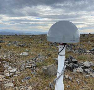
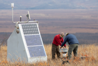
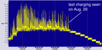
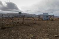
In August 2025, the field team reported good news a decade in the making: the Deception Hills (DCPH) seismic station is back online!
Scenarios demonstrate earthquake early warning benefits for Alaska
Knowing what an earthquake early warning system is capable of is a critical first step in making it work for Alaska.
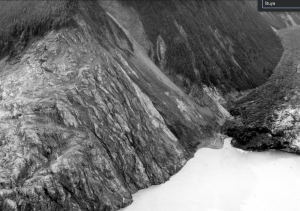
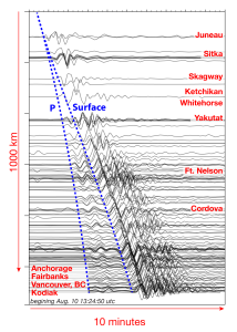
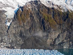
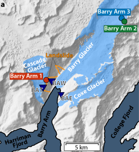
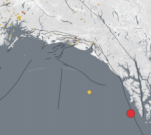
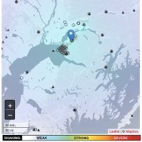
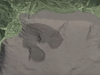
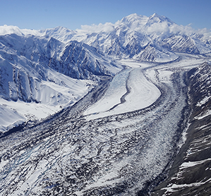
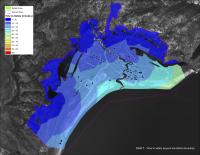
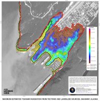
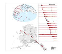
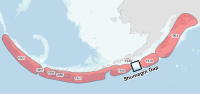
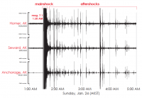
Major Landslide in Southeast Alaska Fjord
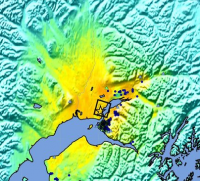
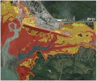
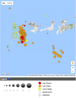
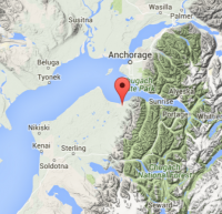
Early on August 10, 2025 the Earthquake Center received reports from people out boating of a mysterious local tsunami in the Endicott Arm area of Southeast Alaska, with waves of 10–15 ft near Harbor Island (Figure 1).
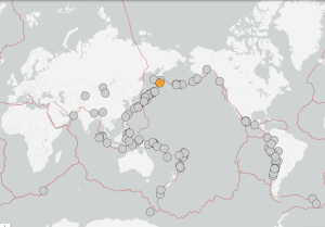
Russia Quake Sends Waves to Alaska
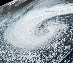
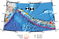
The July 29, 2025 magnitude 8.8 earthquake off the coast of Kamchatka, Russia, is now tied for the 6th-largest recorded in the world (Fig. 1). It was followed immediately by tsunami alerts that spanned the Pacific, including Alaska.
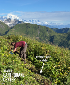
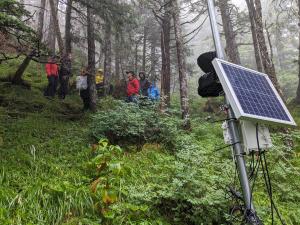
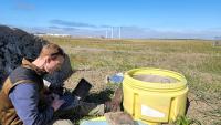
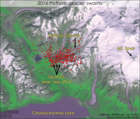
What it takes to catch a landslide in Alaska
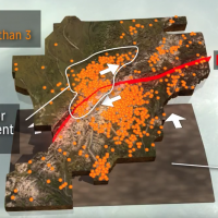
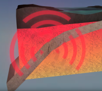
The Alaska Earthquake Center has been using seismic instruments to monitor unstable slopes in Prince William Sound since August 2023 (Figure 1).
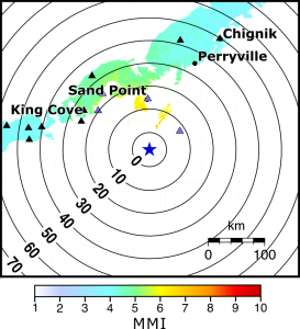
2025 Magnitude 7.3 Sand Point Earthquake
On July 16, 2025, at 12:37 PM Alaska time, a magnitude 7.3 earthquake struck offshore of the Alaska Peninsula region (Figure 1), two years after a previous
Staff Spotlight: Beth Grassi
Beth Grassi’s passion for words began as soon as she could write sentences. How she landed in a role communicating natural hazards at the Alaska Earthquake Center is a much longer story.
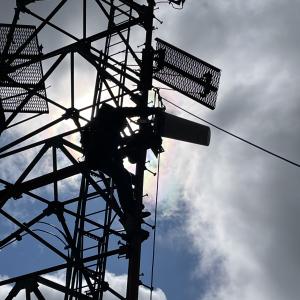
Great View from Up Here: Sitkinak Field Work
As a field intern fresh out of climbing training, the possibility of getting to use my new knowledge on a real site with a real tower was super exciting.
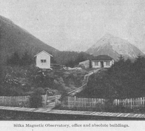
Alaska's First Seismic Station
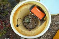
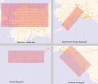
With a current network of over 250 seismic stations, the Alaska Earthquake Center maintains an impressive seismic grid across the state. But how did it all begin?
Earthquake Center, This Is Your Data Calling
How does the Alaska Earthquake Center gather data from more than 250 seismic stations scattered across the state, some in remote locations? Any way we can! We use a complex set of radios, cell modems, routers, and satellite receiver instruments.
Vibrations so small you can’t feel them hold Alaska climate secrets
Tiny Gulf of Alaska ocean wave vibrations unnoticeable by humans reach as far north as the state’s Arctic coastline.
Here Comes the Sun and There Goes the Field Team
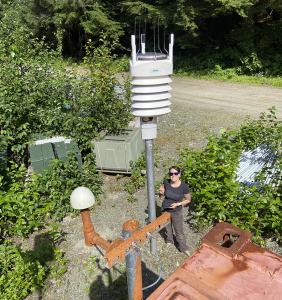
From deep snowfields to mosquito-thick tundras, Alaska Earthquake Center field crew technicians crisscross the state to maintain and upgrade our seismic monitoring network of over 250 stations.
Metal mushrooms pop up at seismic stations
Over the course of several visits to the Alaska Geophysical Network site at Porcupine Dome last summer, Earthquake Center field engineer Ca
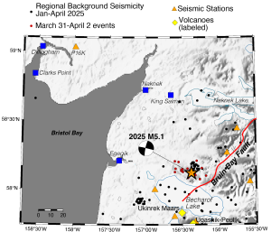
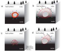
Magnitude 5.1 Alaska Peninsula Earthquake Validates Active Fault Status
On the evening of March 31, 2025, a magnitude 5.1 earthquake shook the Alaska Peninsula and surrounding area.
Staff Spotlight: Samantha Wiser
In the world of earthquake monitoring, where every second counts and every detail matters, Samantha Wiser, our Program Coordinator, ensures the Alaska Earthquake Cent
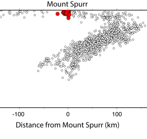
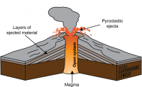
Seismic Action at Mount Spurr Volcano
The past few weeks have seen a notable rise in attention to the possibility that Mount Spurr Volcano is nearing eruption, in part because of escalating seismicity.
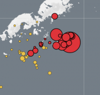
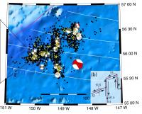
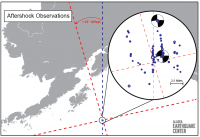
New Earthquake Swarm Near Andreanof Islands
As of today, March 21, 2025, there have been eight earthquakes greater than magnitude 5 in two days in the Andreanof Islands region of the western Aleutian chain (Figure 1).
2024 Seismicity Year in Review
Alaska had a relatively quiet 2024 as far as numbers of seismic events, but several earthquake swarms kept things interesting. Even a “quiet” year, however, keeps the Earthquake Center busy:
A Surprising Shake in Southcentral Alaska
Residents in and around Takotna, Alaska were surprised on the evening of January 29, 2025 by significant shaking from a magnitude 5.2 earthquake.
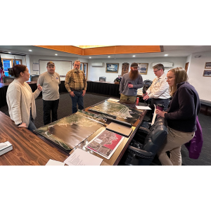
A Visit to Spread Tsunami Preparedness
Every year, the Alaska Earthquake Center issues new maps and reports that detail the history and hazards of tsunamis in a handful of coastal communi
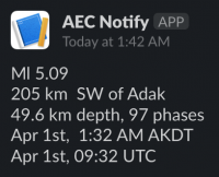
Earthquake Swarm Emerges Southwest of Adak Island
Mid-day on Sunday, December 8, 2024, a magnitude 6.3 earthquake was recorded southwest of Atka Island in the western Aleutians (Figure 1). The earthquake triggered interest because of its significant size.
Tsunami Hazard Resources to Help You Plan
Tsunamis can arrive within minutes in Alaska’s coastal communities. Do you know where to go?
Quakes and Climate: Insights from the Alaska Earthquake Center
Monitoring climate seems distantly related to the work of the Alaska Earthquake Center, but it can actually improve our seismological studies.
The Ghost Forest of Girdwood
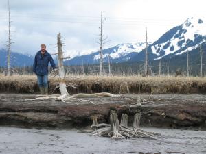
Upper Cook Inlet’s history of earthquakes and tsunamis is written in mud and dead trees.
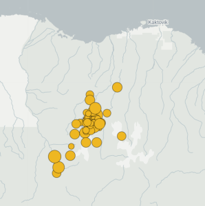
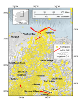
October earthquake uptick south of Kaktovik
In early October, we detected a notable increase in earthquake activity about 50 miles south of Kaktovik in the northeastern corner of Alaska (Figure 1).
Google expands earthquake alert coverage in U.S.
Google announced today that its Android phones will soon receive earthquake alerts in the U.S., including Alaska.
Triggered earthquakes and (not) predictions
We’ve had a surge in inquiries in the past several days, related to Japan’s magnitude 7.1 earthquake on August 8, 2024.
Battery Swap Fever
Keeping the Alaska Earthquake Center’s seismic network of more than 250 stations powered through all sorts of conditions is one of the field team’s crucial tasks year-round.
What’s Rattling the Goldstream Valley
Beginning in April 2024, the Alaska Earthquake Center started hearing reports from residents around Fairbanks who were feeling shaking that wasn’t quite what they were used to from earthquakes.
Let It Go: Earthquake Swarm Releases Strain along the Subduction Zone
Late on May 1, 2024, a flurry of earthquakes rattled offshore of Herbert Island. In the span of 12 minutes, four earthquakes over magnitude 5 ruptured in the Fox Islands region of the Aleutian Islands (Figure 1).
Alaska Earthquake Science at America’s Largest Seismology Conference
The Alaska Earthquake Center will be going in large numbers to this year's Seismological Society of America Conference in Anchorage, Alaska.
Earth Observation Club Students Visit the Nation’s Capital
Early in 2024, U.S. Representative Mary Peltola, the first Alaska Native woman elected to Congress, toured the new Makerspace classroom at North Pole High.
Staff Spotlight: Heather McFarlin
Ensuring the Alaska Earthquake Center produces high-quality data, examining volcanic ash, and classifying volcanic earthquakes, all stem from a childhood fascination for Heather McFarlin, the Earthquake Center’s seismic data manager.
Looking back 60 years: How the Great Alaska Earthquake compares
On March 27, 1964, at 5:36 p.m. local time, an earthquake of magnitude 9.2 initiated in the Prince William Sound region of Alaska. The Great Alaska Earthquake remains the second-largest ever recorded in the world.
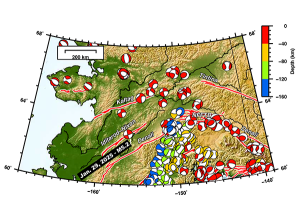
2023 Seismicity Year in Review
When Alaska has less than 50,000 earthquakes in a given year, we consider it quiet. 2023 was a quiet year for Alaska, with the Alaska Earthquake Center reporting 45,546 seismic events in Alaska and neighboring regions (Figure 1).
New detection method aims to warn of landslide tsunamis
A cascade of rock — 180 million tons of it — poured into Alaska’s Taan Fjord near the head of a retreating glacier on a mid-October’s night in 2015 (Figure 1).
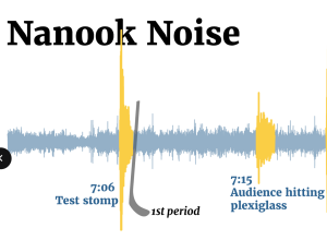
Nanook Noise Rumbles Fairbanks
“Let’s make some NOOOOOOISE!” the announcer called to the crowd.
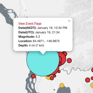
Magnitude 5.3 Earthquake Near Salcha Rattles Interior Alaska
The Alaska Earthquake Center was in the midst of giving a tour to a group of international Arctic Weather Workshop attendees when suddenly, the ground started to shake.
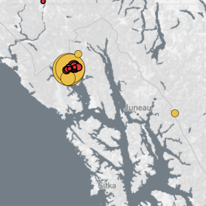
Magnitude 5.9 earthquake felt across southeast Alaska
A magnitude 5.9 earthquake shook southeastern Alaska at 10:46 p.m. local time on Thursday, January 11, 2024 (January 12, 7:46 UTC).
A Seismic Record in the Wind
Because earthquakes tend to grab the most attention, the majority of the seismic record—the noise, or “background” to earthquakes—is commonly ignored.
Faults Put the Squeeze on Glacier Bay Region
Two moderate-sized earthquakes—magnitudes 5.1 and 5.3—occurred near Glacier Bay in Southeast
How to Make Earthquake Early Warning Work in Alaska
Earthquakes happen in Alaska. A lot. How would an earthquake early warning system work here?
Staff Spotlight: Gabe Paris
Gabe Paris is part of the Earthquake Center’s Systems Team that helps keep data flowing from our field stations and shapes it into products for researchers and others interested in Alaska’s seismic activity.
Morocco Quake Echoes in Fairbanks
When you live in a seismically active place like Alaska, a devastating earthquake like the recent one in Morocco (see Figure 1) may rightly make you ask, “Could something like that happen here?” The answer is—Yes. And no.
New analysis finds real, though rare, tsunami threat to upper Cook Inlet
Scientists assessing tsunami threats throughout Alaska recently modeled the flooding scenario of the 1964 Great Alaska Earthquake and discovered that a tsunami could reach upper Cook Inlet, countering a long-held public belief that the region has
Staff Spotlight: Elena Troshina
For Elena Troshina, studying all kinds of waves for her Bachelor’s degree in radiophysics and electronics at Gorky State University, Russia, led to making waves as a career—studying tsunami hazards in Alaska.
Alaska and Puerto Rico High School Students Connect through Seismology
One month after his team received an award for creating the best seismic alarm system at the 2023 Shake Challenge Symposium in Fairbanks, Alaska, 15-year-old Merlin Matcian from Chevak, Alaska found himself installing a seismograph in “La Placita”
Magnitude 7.2 Earthquake South of Sand Point
On July 15, 2023, at 10:48 pm Alaska time, a magnitude 7.2 earthquake struck the offshore Alaska Peninsula region, almost three years after the
M4.6 Earthquake Wakes Up Eagle River
This morning’s M4.6 earthquake under Eagle River (Figures 1 & 2) at 6:47 am on July 3, 2023 woke up many people in Eagle River, Anchorage, and throughout the Mat-Su V
Field Work in Gambell
St. Lawrence Island lies in the Bering Sea, just south of the Bering Strait, and is one of the most remote places in North America. The island is only 45 miles (72 km) from Russia—you can clearly see the Russian coastline from the village shore.
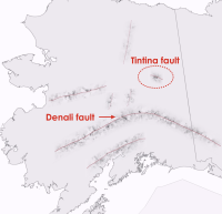
TINTINA FAULT EARTHQUAKE NEAR CENTRAL, ALASKA
Though I was awake in bed at 6:32am on Sunday morning (June 11, 2023) and did not feel it, folks across a swath of the Interior felt a M5 earthquake that occurred ab
How Long Does an Earthquake Last?
Someone recently asked, “Why doesn’t the Alaska Earthquake Center report how long an earthquake lasts?” We could ask in reply, “Do you mean the earthquake itself or the shaking you feel under your feet?” Let’s dive into the process of an earthquak
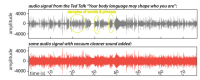
“Attention Chevak, this is an Earthquake Alert: Please take cover!”
Your browser does not support the audio element.
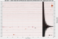
2022 Seismicity Year in Review
Alaska had a relatively quiet 2022 as far as earthquakes go. Overall, the Alaska Earthquake Center reported 47,045 seismic events in Alaska and neighboring regions in 2022 (Figure 1).
A Day in the LIfe of a Seismic Data Analyst
Have you ever wondered how seismic analysts locate earthquakes? Or maybe why earthquake solutions change over time? With the Alaska seismic monitoring network, we record an average of 100+ events daily.
The Alaska Geophysics Network: More than just Earthquakes!
Historically, the Alaska Earthquake Center has focused on seismic data. We currently maintain more than 250 stations across Alaska with broadband and/or strong motion seismometers.
Seismology in Schools Program Gets Students Shaking in Rural Alaska
"Could the seismograph detect how strong the waves crash against our island?" asked a student at Shishmaref School.
Staff Spotlight: Natalia Ruppert
Natalia Ruppert came to Alaska planning to stay for a semester. More than two decades later, she’s built a career at the Alaska Earthquake Center.
Earthquake Center Website Down for Maintenance 5/13 & 5/20
Just a little heads up…
The Alaska Earthquake Center website and data processing will be shut down during University of Alaska Fairbanks planned maintenance on:
Coastal M5.4 Earthquake Likely From Within the Subducting Slab
The M5.4 earthquake on Sunday morning March 19th was widely felt in Kenai Peninsula communities and as far as the MatSu valley (Fig. 1). With a depth of 40.6 miles, it is likely that this earthquake occurred in the Pacific Plate.
The 2002 Denali Fault Earthquake: Twenty Years of Shaking Up Alaska Seismology
On November 3, 2002, a magnitude 7.9 earthquake shook Interior Alaska for two to three minutes, the largest inland earthquake in North America in 150 years.
Magnitude 4.8 earthquake rattles Interior
The M4.8 earthquake that was felt widely on Sunday evening (September 18, 2022) occurred along a well-known fault system about 40 miles west of Fairbanks (Fig. 1).
Staff Spotlight: Mitch Robinson, Snippets of a three-decade career
Mitch Robinson is retiring after 33 years at the Geophysical Institute. Throughout those decades he has been a quiet, steadfast part of the UAF and GI community.
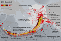
2021 Seismicity Year in Review
Seismicity for 2021 has been analyzed, quality controlled, and cataloged (figure 1). Despite the largest U.S.
What happens when background noise is louder than an earthquake?
Noise is all around us, all the time. Vibrations in the earth are much the same. Natural and anthropogenic (or man-made) vibrations are a constant source of noise that is recorded on seismic sensors around the world.
A M4.9 Jolt in Interior Alaska
(September 14, 2021) Tonight’s M4.9 earthquake at 9:56pm rattled the Interior, with felt reports from Fairbanks, North Pole, Salcha, Nenana, Healy, Cantwell, Delta
Staff Spotlight: Ezgi Karasözen
From Mars research to earthquakes in Alaska, postdoctoral researcher Ezgi Karasözen has covered a lot of ground.
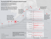
Largest earthquake in 50 years: What we know so far
At 10:15pm Alaska time on July 28, 2021 a magnitude 8.2 earthquake struck offshore of the Alaska Peninsula, the largest U.S. earthquake in 50 years.
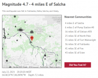
How a small earthquake in Salcha can remind us of our history
Many people in Interior Alaska felt the M4.7 earthquake near Salcha tonight, July 22, 2021, at 8:20 pm AKDT (Figure 1).
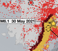
M6.1 earthquake: A well-known process, in an interesting location
The magnitude 6.1 earthquake late in the evening on Sunday May 30 occurred about 100 km, or 60 miles, east of Talkeetna and was felt across much of mainland Alaska.
That’s Deep: M5.5 April 8 Earthquake felt across Alaska
At 9:10am on April 8, 2021 Alaskans from the Kenai Peninsula to Fairbanks had a little shakeup to start their day when a magnitude 5.5 earthquake hit.
Why Should You Bother with a 'Did You Feel It' Report?
When people report to the Earthquake Center that they have felt an earthquake on social media, we encourage them to submit a Did You Feel It?
New multidisciplinary project will boost understanding of earthquakes and Arctic change in Alaska
(November 11, 2020) A new collaborative project will make it possible for scientists to use real-time seismic, weather, and infrasound (sounds below levels that humans can hear) observations to track a suite of phenomena ranging from eart
What is a landslide tsunami again?
Tsunamis caused by submarine (below water) and subaerial (above the water) landslides are a serious hazard in bays and fjords of coastal Alaska, particularly in Southeast and South-central Alaska.
Alaska Earthquake Center’s seismic network covers new ground
During 2019-2020, the Alaska Earthquake Center underwent an unprecedented expansion of our permanent seismic monitoring network. We were able to achieve it by acquiring 96 of 158 temporary USArray sites in Alaska.
The unusual M7.6 aftershock of the M7.8 Simeonof earthquake
On October 19, 2020 a magnitude 7.6 earthquake shook the ground in the vicinity of the July 22, 2020 M7.8 Simeonof earthquake aftershock region (Figure 1).
Earthquake Energy release and the M7.8 Simeonof Earthquake
On July 22, 2020, a major M7.8 earthquake struck the Shumagin Islands region of the Aleutians, just south of Simeonof Island.
Staff Spotlight: Evan McArthur
Running a statewide seismic network requires expertise you might not immediately associate with earthquake research.
M7.8 Simeonof Earthquake Recorded Globally
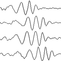
Large earthquakes, like the recent M7.8 in Alaska, can be seen at seismometers around the world! When an earthquake occurs, seismic energy travels in all directions, much like ripples in a pond.
Muldrow Glacier
The Muldrow Glacier, which flows from Denali, experienced a surge from December 2020 to July 22, 2021, with speeds at times approaching 20 meters per day.
M7.8 earthquake near Simeonof Island
This evening’s M7.8 earthquake [7/21/20, 10:12 PM AKDT] occurred on the well-known subduction zone interface off the Alaska Peninsula. Strong shaking has been reported from Perryville and Sand Point to King Cove and Cold Bay.
What is causing seismicity near Mt. Ogden in Southeast Alaska?
Seismic activity near Mt. Ogden and Wright Glacier, about 40 miles east of Juneau, picked up starting on July 10, 2020 (Figure 1). Juneau residents may have felt some of these quakes.
What is magnitude of completeness?
We use the phrase “magnitude of completeness” often when referring to our understanding of seismicity in a region or following a sequence of earthquakes. This value is a simplistic assessment of a catalog of earthquakes.
What happens in the first 20 minutes after an earthquake?
“As far as earthquakes go, for everyone in Alaska, there is someone looking out for you 24/7,” said Ken Macpherson, who manages the Alaska Earthquake Center’s data analyst team.
Unraveling current earthquakes in the western Aleutians
We are getting questions about current earthquake activity in the western Aleutians—and with good reason. There are actually two different sequences of earthquakes unfolding right now in the Andreanof and Rat Islands.
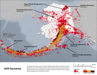
2019 Is Runner Up for the Highest Number of Earthquakes: Alaska Seismicity Summary
Seismicity in Alaska had another stand-out year in 2019. With a total of 50,289 reported earthquakes, 2019 finished as a runner up to the record-breaking 2018 (figure 1). The earthquake depths ranged between 0 and 165 miles (265 km).
Response of the UAF Engineering Building to Jan. 14 earthquake
On Tuesday morning a magnitude 3.7 earthquake occurred about 16 miles SW of Ester, rattling folks across the Fairbanks region.
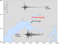
The Anchorage Earthquake: One Year Later
As we approach the one-year anniversary of the M7.1 Anchorage Earthquake on November 30, 2018, we reflect on the scientific and societal impacts of the earthquake.
Staff Spotlight: Natasha Kozyreva
Natasha Kozyreva (or Natasha K. as her colleagues call her) came to Fairbanks in 2005.
Not all ground-motion sensors are created equal
You may be surprised at the diversity of sensors that are able to detect seismic waves.
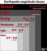
Earthquake magnitude classes
After an earthquake, you’ll often hear a seismologist say something like “A moderate earthquake has occurred in the southcentral region of Alaska.” But what does that mean?
Introducing the mobile-friendly tsunami hazard map tool
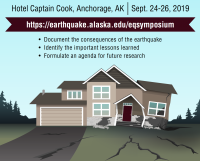
Symposium on the Anchorage earthquake, September 24-26
Registration is open for this retrospective on the M7.1 earthquake last November. This is a diverse gathering of professionals who are vested and interested in helping shape the lessons learned from this event.
Informing fieldwork decisions from the lab
Our staff spend much of their time each summer working in the field on the stations that make up our seismic network, but the work of maintaining these stations is not limited to the summer or even to the field.
What is an earthquake swarm?
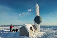
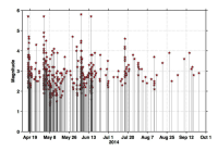
If you've paid much attention to earthquakes in Alaska over the last few years, you've probably heard the phrase “earthquake swarm.” In 2014, a swarm near Noatak rattled residents with five magnitude 5.3-5.7 earthquakes spread out over two mo
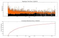
November 30 Anchorage earthquake revised to magnitude 7.1
The Alaska Earthquake Center is revising the magnitude of the November 30, 2018 Anchorage earthquake from 7.0 to 7.1. In the three months since the earthquake, data have been reviewed carefully by numerous agency and academic groups.
Why a small tsunami is not a false alarm
On July 28, 2021 tsunami warning sirens sounded in coastal towns along southern Alaska and the Alaska Peninsula.
Why magnitudes evolve in the minutes after an earthquake
If you've ever read one of our old information releases, you might have noticed the phrase "The magnitude and location may change slightly as additional data are received and processed." The words probably make sense, but the reasons are a bit sub
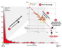
When will the aftershocks stop?
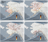
The burning question on the minds of many residents in Southcentral Alaska is, “When will the aftershocks stop?” This is a tricky question, but enough time has passed since the November 30 magnitude 7.1 earthquake for us to make an informed estima
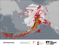
2018 Year in Review
We recorded more than 55,000 earthquakes in Alaska last year. We would give you an exact figure, but we're still counting.
Are these aftershocks normal? Yes, they are.
Since the Nov. 30 Anchorage earthquake, we’ve fielded far more questions about the aftershock sequence than we have about the magnitude 7.1 mainshock that started them.
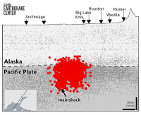
Using aftershocks to define fault ruptures
Here is a cross-section through Friday’s earthquake and subsequent aftershocks. The mainshock symbol marks where the M7.1 earthquake began.
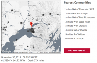
Anchorage M7.1: What we know so far
Updated December 2, 2018
What Ground Motion Visualizations Can Say About Earthquake Properties
Sometimes after a significant earthquake, the Alaska Earthquake Center will publish a short movie showing ground motions recorded on seismic stations around the state.
Phantom quakes: what they are and why they're getting scarcer
If you were one of the thousands of people visiting our website this morning or using one of the numerous services that repost our data (various phone apps, USGS, etc.) you may have seen listings for two magnitude 5 earthquakes at the same time ne
Knowing where to go with pedestrian tsunami evacuation modeling
Knowing where to go during an evacuation is crucial to survival when you are in a tsunami hazard zone. But how do emergency managers and planners decide where the safe zones are and where to stage assembly areas in a community?
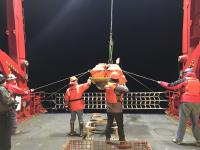
Temporary Array of Ocean Bottom Seismometers in Gulf of Alaska and Alaska Amphibious Community Seismic Experiment
For two weeks in July I was onboard the Research Vessel Sikuliaq as an apply-to-sail participant of the
Three stages of earthquake locations: Automatic, Reviewed, Revised
When we feel an earthquake, we can't know right away where it happened. A person occupies one spot, and earthquakes can happen all around us, at different depths.
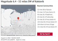
M6.4 Kaktovik earthquake: the largest ever on the North Slope
On Sunday morning at 6:58 Alaska time, we recorded a magnitude 6.4 earthquake 52 miles southwest of Kaktovik. It was, by a wide margin, the largest earthquake ever recorded north of the Brooks Range in Alaska.
How's It Shaking? Structural Monitoring in Alaska
In early 2016, UAF Assistant Professor Dr.
Bear Damage on Baldy Mountain
Not only do our remote seismic stations need to survive temperatures far below zero, heavy snows, ice, winds, rains, lightning strikes, and warm, muddy summer months, our stations must also withstand abuse from all variety
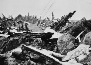
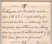
60 years ago: The 1958 earthquake and Lituya Bay megatsunami
Lituya Bay
A flying boat dropped Paddy Sherman’s mountaineering expedition at Lituya Bay on June 17, 1958.
The Offshore Kodiak earthquake, 3700 aftershocks later
Halfway through 2018, January's magnitude 7.9 earthquake in the Gulf of Alaska remains the year's largest quake worldwide.
When is an earthquake about to happen? Foreshocks, Earthquake Nucleation, and Earthquake Prediction/Forecasting
For decades, there have been tantalizing clues about how we might know when an earthquake will happen. Sometimes, clusters of small earthquakes called foreshock sequences come in the days or weeks before a large earthquake.
Landslide tsunamis: why they're different and how to prepare
Alaska's most recent deadly tsunami struck without warning on November 3, 1994. Witnesses described new steel sheet piles snapping in half as the railway dock, which was being refurbished, suddenly slid away from the shore.
Finding faults in northeast Alaska
With only a handful of known active faults across northeast Alaska, you might not expect much in the way of earthquake activity. You’d be mistaken.
With a trip to Chirikof Island, field season is underway
Two of our field crew, blessed with adequate weather, made the 180-mile flight from Kodiak to Chirikof Island last week. Once there, they replaced two aging seismometers, measured battery voltages and radio signal strength, and then
Tsunami observations from the Offshore Kodiak earthquake
We spend a lot of time at the Earthquake Center anticipating what will happen during large earthquakes. For earthquakes occurring off the coast, tsunamis are one of our greatest hazards.
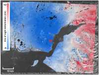
Seismology vs. Geodesy: Competing observations from the Offshore Kodiak Earthquake
When a large earthquake occurs, geophysicists have many tools at their disposal to determine the properties of the fault (or faults) that ruptured during the earthquake.
Introducing the Revamped Recent Earthquakes Map
You may have noticed that we've launched an updated version of our recent events page.
The goals of the revamp were twofold:
Anniversary of the 1964 earthquake: A day to reflect on preparedness
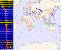
The North Korean nuclear test: A rare glimpse of the deep Earth?
(Sept. 8, 2017) When the North Koreans set off their latest nuclear test last Sunday, we were the first to record the explosion signal as it reached U.S. soil.
A New Perspective on Seismic Hazards in the Shumagin Gap
(August 3, 2017) Recently, many national news outlets picked up a story about the earthquake and tsunami threat posed by Alaska’s Shumagin Gap.
July 17, 2017 M7.7 Komandorskie Islands earthquake: A missing piece of the tectonic puzzle
(May 8, 2017) After a long spell with few earthquakes strong enough to be felt, over the last ten days we've had 3 earthquakes larger than magnitude 6, seven larger than M5, and more than fifty larger than M4.
Earthquakes in the Denali Region
Earthquakes beneath and around Denali are very common and in fact encapsulate three stories of Alaska seismicity in one location. Last night’s (Tuesday 31 January 2017) magnitude 5.2 earthquake is just one part of the Denali regional story.
The almost forgotten earthquake of the Alaska Gold Rush
UAF's Carl Tape will be speaking on Tuesday night in Fairbanks about his research into an elusive 1904 magnitude 7.3 earthquake that happened, we now believe, somewhere near Lake Minchumina. This is a detective story.
Many of you have noticed the significant swarm of small quakes occurring about 8 miles west of Mt. Spurr. Since June 11, there have been hundreds of earthquake-like events with magnitudes up to 2.4.
An eruption without earthquakes?
Pavlof volcano began a new eruption on March 27 with little advance warning.
M4.2 near Hope: not an aftershock
At 1:41 Monday morning, many in the Anchorage and Kenai regions woke to the shaking of a magnitude 4.2 earthquake centered 13 miles west of Hope.
Animation: the source of the Iniskin earthquake
Most people can visualize how earthquakes are generated at plate boundaries, where one plate grinds against or collides with another.
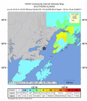
Four hundred miles from the epicenter, at 1:30 in the morning, many in Fairbanks did not feel the earthquake at all. For those who did, it lasted for a long time and came as two distinct, widely separated shocks.
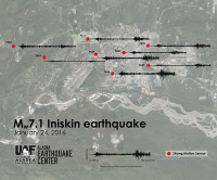
Magnitude 7.1 Iniskin earthquake
A damaging magnitude 7.1 earthquake occurred at 1:30am Sunday, 60 miles west of Homer. So far there are no reports of injuries.
Thoughts on the North Korea nuclear test
The recent nuclear test in North Korea presents a quandary for seismologists. The political posturing and global tension these events create is significant. And yet scientifically, they are fascinating.
A decade of glacier "icequakes"
As we head into winter, seismic events generated by glaciers—so-called icequakes—have quieted down for the season. Each year, hundreds of these icequakes are large enough to be caught by our standard earthquake detection routines.
Surveying for tsunami safety
Fall might not be the most prudent time for a surveying trip to the Aleutians, but Zeb Maharrey and I lucked out with some beautiful days and only a few periods of cold, blowing rain.
We are live!
We are thrilled to introduce a completely redesigned website for the Alaska Earthquake Center.
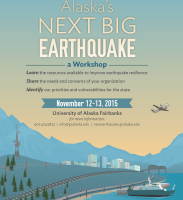
Alaska’s Next Big Earthquake - a workshop
Registration closes in a few days for this workshop being hosted at UAF on Nov. 12-13.
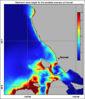
New Tsunami Maps: Elfin Cove, Gustavus, and Hoonah
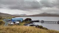
Yesterday we left Fairbanks at six in the morning and drove 100 miles up the Steese Highway, where we met Rick Swisher of Quicksilver Air in his black Robinson R44.
Noatak swarm winding down?
It's been nearly a month since the September 25 magnitude 2.9 earthquake that, at least for now, stands as the last event in the Noatak swarm.
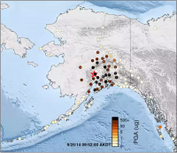
October 13 - PGA animation
People are often surprised at how sensitive our instruments are to earthquakes. This animation shows seismometers across Alaska as they respond to shaking from the magnitude 6.3 Skwentna earthquake on September 25.