


The Alaska Earthquake Center will be going in large numbers to this year's Seismological Society of America Conference in Anchorage, Alaska. SSA 2024 will be the largest ever, with over 1,100 people registered, and it is the first to be hosted in Anchorage since 2014.
University of Alaska Fairbanks seismologists Michael West and Carl Tape are this year’s conference co-hosts. “Earthquakes, tsunamis, landslides, volcanoes, Earth’s structure, plate tectonics and the evolving geology around us — this is the meeting for it,” says West, who is also the state seismologist and director of the Earthquake Center.
Some highlights of the 10 Alaska Earthquake Center-led presentations include steps toward earthquake early warning in Alaska, the newest insights into tsunami hazards, and the evolution of our workforce development program. Thirty students from the Earth Observation Club after-school program, a collaboration with T3 Alaska, will travel from across rural Alaska to present results from their community projects. These include monitoring events such as sea-ice breakup, permafrost and riverbank erosion and flooding, and seismicity around landslide-prone areas. A plenary panel, co-hosted by tsunami researcher Elena Suleimani, will focus on the challenges of geohazards research in Alaska.
The Earthquake Center is also co-hosting a booth with the University of Alaska Fairbanks Geophysical Institute, where conference attendees can learn more about our research and facilities. They can also compete for prizes in various seismology challenges, like “Guess that Waveform!”, setting up a seismic data stream, and racing an opponent to disassemble and reassemble the protective housing unit for seismic station electronics, known as a Vault Interface Enclosure.
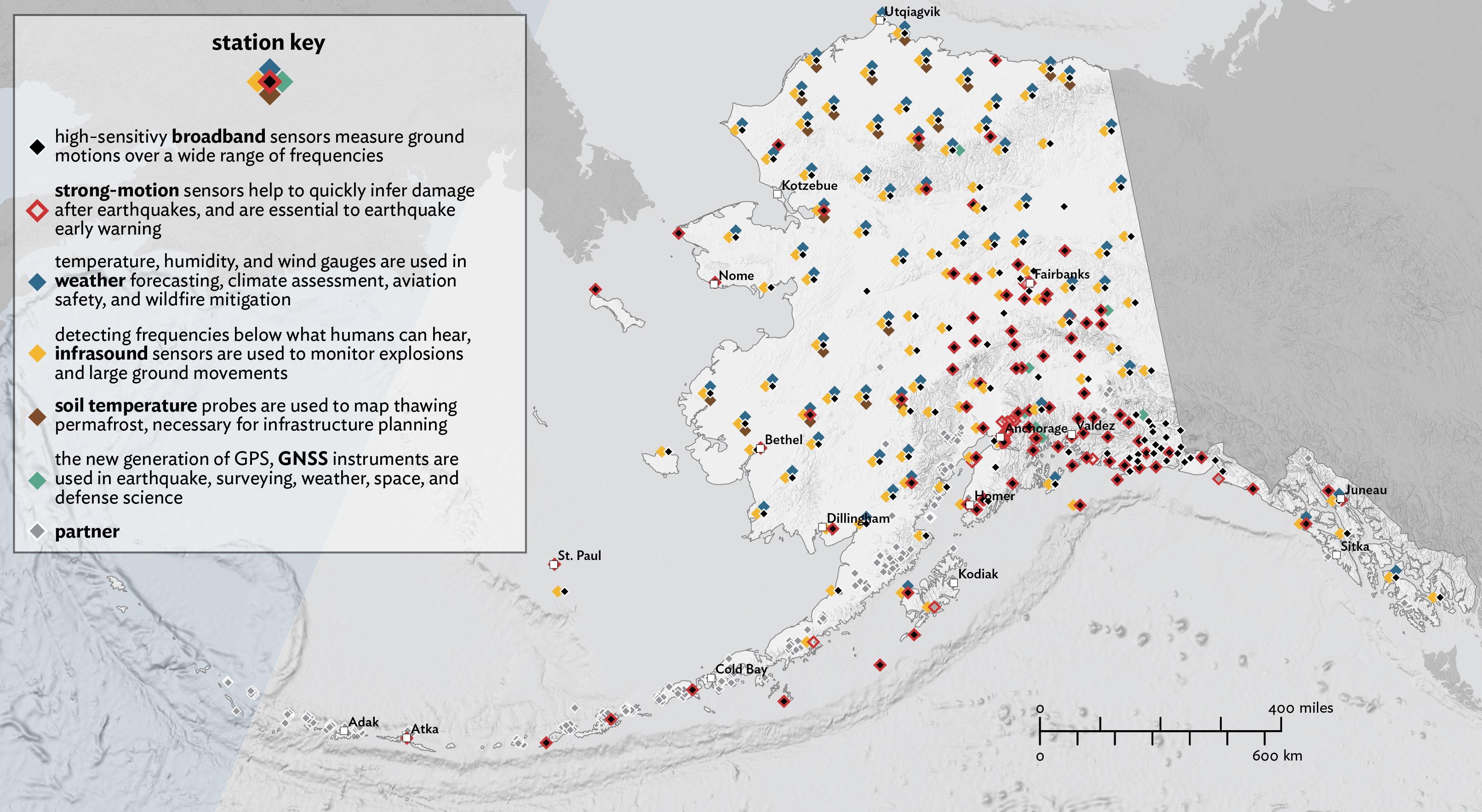
Whether a bear has wandered too close to a field site or weather conditions changed without warning and your helicopter pilot says it's time to go, working fast is a necessary skill for maintaining the Alaska Geophysical Network’s stations.
The Geophysical Institute will show videos of field- and lab-based research in Alaska at this year’s SSA meeting, in order to attract graduate student applicants. Graduate student ambassadors—Alaska Earthquake Center researchers Sarah Noel and Sebin John—will be on hand to answer questions.
From seismic data manager Heather McFarlin, we learn about how the data team monitors station health and performs quality control. These analyses ensure that we produce quality data for researchers and deliver accurate earthquake information to the public. Graduate student and Geophysical Institute student ambassador Sarah Noel will showcase her work on machine learning. She’s been comparing an automatic earthquake detection and classification system for four Alaskan regions to the earthquakes cataloged by analysts.
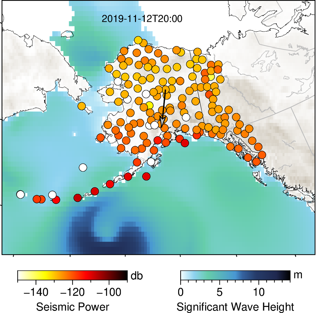
State seismologist Mike West will be presenting on how the variety of environmental data we track helps us improve our understanding of earthquakes. On the flip side of this, field engineer Joanne Helsop will present the climate story—how the range of environmental and geophysical conditions monitored by the Alaska Earthquake Center give insight into changing Arctic conditions. In a related presentation, graduate student Sebin John will share his research on microseismic noise from ocean storms and sea ice in the Gulf of Alaska.
Presenting on Earthquake Early Warning, we have graduate student Alex Fozkos. Advances in landslide detection in Alaska will be presented by research seismologist Ezgi Karasözen and graduate student Gabrielle Davy.
Gabe Paris will present on how the Alaska Earthquake Center uses Global Navigation Satellite System (GNSS) data receivers to calculate earthquake magnitude more accurately, by incorporating measurements of exactly how much the earth moves during an earthquake.
Hosting the conference in Alaska gives the Alaska Earthquake Center the chance to showcase the many different ways our research serves Alaska and science.