


Ensuring the Alaska Earthquake Center produces high-quality data, examining volcanic ash, and classifying volcanic earthquakes, all stem from a childhood fascination for Heather McFarlin, the Earthquake Center’s seismic data manager. “I’ve always loved earth science and geology,” she says. “My dad was a hard rock driller and was really into science. His family could only afford to send the oldest kid to college, and he was the youngest, so he didn’t get a chance to go. He loved learning, especially science and history–he always tried to learn as much as he could from the geologists on his drill crew. He instilled that love of science in me.”
At the Earthquake Center, Heather supervises the analyst team and manages data quality control. The analyst team is responsible for verifying every earthquake in Alaska that the center records. “We have a team of 3 that analyzes about 50,000 earthquakes per year,” Heather proudly states.
On the QC side, “I work with our field and systems teams to make sure our data is of good quality for users: our analyst team, other researchers, and agencies.” Heather has learned how to do quality control as she goes, testing out what is most useful. Sometimes that means breaking new ground. “There’s still so much we can do. We’re installing a bunch of strong motion sensors. We need to develop strong motion metrics—there’s just not much for that in the literature.”
Creating a pathway is familiar to Heather. She earned a Bachelor’s degree in Geography at the University of Wisconsin-Whitewater, an environmental science minor, and a GIS certificate while raising a young child. In one of her first classes, they had an assignment to find what kind of jobs were related to the field that interested them. “All of mine were volcanology and seismology,” Heather recalls. She was one of only three undergraduates who did a thesis project, so they worked with the department chair to shape what that would look like.
Her thesis focused on developing a method of acid digestion to break down volcanic ash into its elements for analysis. “Then you can essentially fingerprint the ash to a specific location and depth where it formed.” The ash samples were from Mt. Unzen in Japan, so she visited that site with funding from ASIANetwork. “I also got invited to a United Nations Educational, Scientific, and Cultural Organization (UNESCO) Geoparks conference for protected UNESCO sites in Shimabara, Japan. These Geoparks are in many countries across the world, so it was a big deal for an undergrad.”
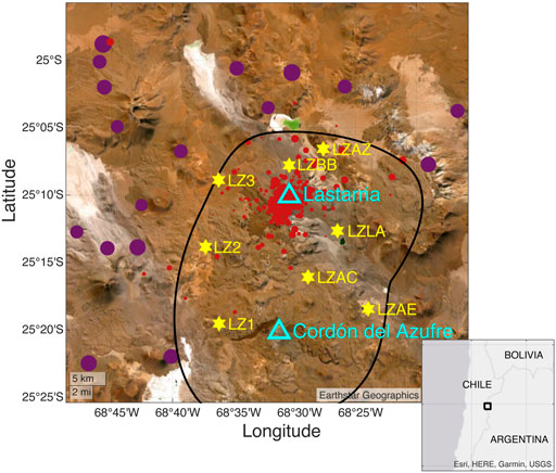
Moving directly into a Ph.D. program, Heather’s research focused on two field sites that were part of the PLUTONS Project: Uturuncu volcano in Bolivia and the Lazufre volcanic zone in the central Andes of Chile and Argentina. (Lazufre is a combination of the names of Lastarria and Cordón del Azufre volcanoes.)
“At Uturuncu Volcano I used receiver functions, a technique for detecting large density contrasts, to find the magma body. It’s one of the largest in the world, about 200 km (~124 miles) across,” Heather explains. Her research gives a better idea than previous studies of the depths of the top and bottom of the “mush” (cooling magma) reservoir. She was lead author on a paper published in Geosphere about her research
Part of Heather’s Ph.D. work could help with future hazard monitoring. At the Lazufre site, the researchers installed a temporary network. “I classified the types of seismic events. No one had tried to locate or classify them before,” says Heather. “Lastarria Volcano is a top 10 hazard in Argentina, so this will provide a baseline for monitoring and maybe support the installation of a permanent network.”
Heather’s Ph.D. work led to her position at the Earthquake Center. Michael West, the Earthquake Center’s director, was the principal investigator for the Lazufre network project. “Mike taught me how to locate earthquakes and how to use the programs we still use today. The people at the Earthquake Center are the best in the business, and I wanted to learn everything I could from them,” Heather says. When the opportunity came to join the team, she took it.
Heather started at the Earthquake Center in 2019 as a data specialist. Her job was part seismic data analyst and part data quality control (QC) monitor. “I was hired to develop a QC protocol,” says Heather. “Before that, it was all ad hoc, there was no system. With the addition of the USArray stations to the Alaska network, the center needed someone to do that.”
About a year later, she jumped into her current leadership role. “The day I started as analyst supervisor was the day of the Simeonof Earthquake,” says Heather, referring to the M7.8 earthquake that generated thousands of aftershocks—and plenty of work for the analysts. “Thanks Shumagin Gap.”
Her favorite part of working at the Earthquake Center? “The people! I love learning from everyone that’s here. Everyone is an expert in something, and getting to learn something from all of them is pretty exciting. And they’re all amazing people!”