


In Alaska, tsunamis can strike within minutes of an earthquake. Tsunami awareness and safety are crucial to anyone who lives, works, or travels along Alaska’s coast.
Historically, tsunamis generated by earthquakes in Alaska have caused damage and loss of life along the West Coast and across the Pacific Ocean. Here in Alaska, tsunamis generated by nearby earthquakes or landslides represent “near-field” hazards. This means people may have minutes rather than hours to reach safety.
Coastal Alaska communities live with the most serious tsunami risk in the United States. The Earthquake Center works to make our coastal communities safer by providing state and local officials with the best possible information for addressing the tsunami hazards faced by their communities. The Earthquake Center is a long-standing partner in the National Tsunami Hazard Mitigation Program. We support community safety through a variety of products. These include scientific maps estimating flooding zones, community tsunami hazard brochures, a story map explaining potential flooding for the City of Anchorage and Upper Cook Inlet areas, and more.
Why tsunamis happen in Alaska
Any large movement of land in or near the ocean can generate a tsunami: earthquakes, landslides, or volcanic eruptions. A tsunami can be a series of waves that may last for hours, and the first wave may not be the largest.
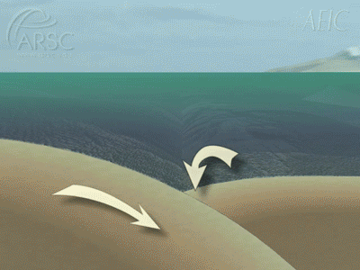
Earthquakes frequently rumble coastal Alaska. A subduction zone lies just offshore, where the Pacific Ocean plate scrapes under the continental plate of mainland Alaska, causing much of this earthquake activity. A tectonic tsunami is caused by an earthquake that shifts the ocean bottom, which displaces water.
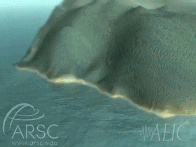
Many places along Alaska’s rugged coast are poised for landslides above or below the ocean’s surface. A landslide may release spontaneously or be triggered by an earthquake. The rocks, earth, and debris released displace water, creating a tsunami. Some of the largest tsunamis in history originated from a landslide.
Volcanic activity such as a mass flow or explosive eruption that displaces water could generate a tsunami. An example of this was the January 15, 2022 eruption of the underwater volcano Hunga Tonga in the southwest Pacific that generated a damaging tsunami. The tsunami caused waves of a little over three feet in King Cove, Alaska. Another example is the 1883 eruption of Augustine Volcano in Alaska. The north side of the peak collapsed in a landslide, generating a tsunami (see Historical Tsunamis section below).
Distant vs. local tsunamis
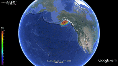
Usually a tsunami is considered distant if it takes more than three hours to reach the observer. Most of the distant tsunamis in Alaska are those triggered by earthquakes located, for example, along the shores of Chile, Japan, Peru, the Russian Far East, or the West Coast of the U.S.
On the flip side, a local tsunami may reach the observer minutes after the landslide or first earthquake shaking. Local tsunamis caused by an earthquake along the Alaska-Aleutian subduction zone, such as in the Gulf of Alaska or offshore of Kodiak Island, are extremely dangerous because the first wave can arrive so quickly, with little time for warnings or evacuation.
Tsunamis caused by submarine (below water) and subaerial (above the water) landslides are a serious hazard in bays and fjords of coastal Alaska, particularly in Southeast and Southcentral Alaska. This region has a long history of tsunami waves generated by submarine and subaerial landslides, avalanches, and rockfalls. These have produced some of the largest tsunami waves recorded and, unlike earthquake-induced tsunamis, they can strike with no warning.
The tsunami travel time maps for various historical events can be accessed here.
High-risk areas
If the ground shakes for more than 20 seconds and it is difficult to stand, and/or the tsunami siren is heard, anyone within the inundation/flood zone should move to higher ground or a tsunami shelter.
Pay attention to unusual sounds and sights when on or near the ocean. Tsunami impacts are greatest near ocean beaches, low-lying coastal areas, and waterways such as harbors and estuaries. Always avoid these areas during tsunamis. A tsunami wave series can last for many hours, so wait for local authorities to announce when these areas are safe. In addition to wave action, tsunamis can stir up currents that threaten harbors, facilities, and boats.
Currently, there are two areas that have been identified as potential tsunami-generating landslides. One in Barry Arm, Prince William Sound and one in Tidal Inlet, Glacier Bay. There are many other potential landslides that have yet to be identified.
Historical tsunamis
Alaskan history is filled with stories of tsunamis. They have caused devastating damage; some landslides produced megatsunamis. Following are accounts of some of Alaska’s largest tsunamis. Run-up is the elevation above sea level that a tsunami wave reaches.
1883 Augustine Volcano tsunami
Augustine Volcano in Cook Inlet erupted in 1883, causing the flank of the volcano to collapse in a landslide. The resulting tsunami reached the opposite side of Cook Inlet, then rebounded back to Augustine Island. An eyewitness account from a trading post about 50 miles away mentioned four wave arrivals. The sea rise was 20 feet above the usual level near Nanwalek (called English Bay at the time). In the nearby village of Port Graham, the waves flooded homes and pushed boats onto shore. Possible casualties were five or six Aleuts in a hunting party reportedly on Augustine Island before the eruption. The timing of the landslide during low tide helped lessen damage in the surrounding communities (in this region sea level can change almost 15 feet between low and high tides).
1958 Lituya Bay megatsunami
Landslides in Lituya Bay in Southeast Alaska following a magnitude 7.8 earthquake on the Fairweather Fault produced a megatsunami with 1,720 feet of run-up. You can read more about this event in 60 years ago: The 1958 earthquake and Lituya Bay megatsunami.
1964 Great Alaskan Earthquake
On March 27, a magnitude 9.2 earthquake, the second largest ever recorded, shook Alaska for nearly five minutes. Originating in Prince William Sound along the subduction zone, the earthquake caused both local and tectonic tsunamis. More than 20 local landslides (both above and below the ocean) generated waves that arrived within minutes in nearby communities, leaving no time for warning or evacuation. Whittier, Seward, and Valdez were struck by waves before shaking had even finished. These local tsunamis accounted for at least 82 of the 122 tsunami-related fatalities. In Valdez Arm, the locally-induced tsunami waves were reported to reach a maximum height of 170 feet (52 meters). Waves from the more distant earthquake-generated tsunami followed, continuing for several hours afterward.
2015 Icy Bay tsunami
The giant wave of Icy Bay, with a run-up of 600 feet, was caused by the collapse of a mountainside near Tyndall Glacier into Taan Fjord after a period of heavy rains. You can read more in Landslide tsunamis: why they're different and how to prepare and Lessons for Alaska from the Palu Tsunami.
Tsunami Safety Partners
The Alaska Division of Homeland Security and Emergency Management offers a wealth of information about earthquake and tsunami preparedness, from tips for home and family safety to neighborhood and community planning.
The National Tsunami Warning Center issues tsunami advisories and warnings for Alaska. The center also provides educational materials, safety information, and tsunami data.
The International Tsunami Information Center provides tsunami warnings from around the world, educational and safety information about tsunamis, historical information, and more.