
Upper Cook Inlet’s history of earthquakes and tsunamis is written in mud and dead trees.
Driving the scenic Seward Highway from Anchorage to Girdwood, at around milepost 90 the pale columns of dead trees catch the eye. Bare of bark, with only the remnants of the thickest branches still reaching out, the “ghost forest” is a memento of the 1964 magnitude 9.2 Great Alaska Earthquake.
The original forest grew in a freshwater area above the ocean’s reach. When the ground dropped about 6.5 feet during the earthquake, it was suddenly below the high-tide level. Salt water from Turnagain Arm of Cook Inlet relentlessly flooded the area at every high tide, killing the trees (figure 1). They remain standing in place, now a silent reminder of where the 1964 earthquake changed the landscape. Marine sediments slowly bury the evidence.
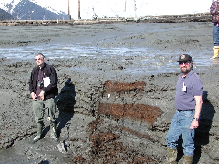
The ghost forest visible from the highway is not alone. Dig a little deeper, and the broken stumps of two previous ghost forests are revealed (figure 2). But ghost trees aren’t the only evidence of the upheaval caused by major earthquakes. In the early 2000s, scientists dug into tidal mud around Girdwood and Anchorage, using a combination of geology and paleontology to decipher the clues of past large earthquakes.
The 1964 earthquake caused the land here to drop several feet relative to sea level. Over a period of several years, silt brought in by the tides buried the ghost tree stumps, grasses, and marsh vegetation, creating a peat layer. "In the peat layers, you can look at the fragile leaves and plant matter that are still in their growing positions, which shows that the subsidence happened fast,” said Barrett Salisbury, Earthquake and Tsunami Hazards Program Manager at the Alaska Division of Geological & Geophysical Surveys. “You can also look at tree rings, which show the tree died quickly. There aren't rings showing the tree wasted away over a long time."
Similar layers of dead marsh vegetation (peat and tree stumps) buried deeper in the tidal deposits provide geologic evidence that 1964-style earthquakes have occurred repeatedly in the distant past (figure 3). Microscopic fossils in these deposits, such as diatoms that lived in intertidal zones, show that the transitions from freshwater to saltwater environments occurred suddenly during tectonic events, rather than gradually due to long-term sea-level rise.
Geologists can also use unique layers deposited in sedimentary soils–for example, ash from the 1912 Novarupta/Katmai volcanic eruption—and other markers and isotopes to help estimate when earthquakes occurred. These ghosts of earthquakes past provide dates of about 900 and about 1600 years ago for two major tectonic events in the Cook Inlet region.
“Researchers studying similar deposits beneath many coastal marshes around Cook Inlet have determined that great earthquakes with the potential to trigger widespread tsunamis have occurred in this area an average of every several hundred years over at least the past five thousand years,” said Rod Combellick, Alaska Division of Geological & Geophysical Surveys.
If you have the chance to pass through the ghost forest of Girdwood, beware the history beneath your feet. Take in the expanse of these pale specters of trees, monuments to the massive scale of Alaska’s tectonic movements. Spooky, indeed!
Learn more
There is a new tsunami brochure available for the Girdwood area, which shows evacuation areas, assembly areas, and more: Know Your Tsunami Hazard in Anchorage, Chugiak, Eagle River, Eklutna, and Girdwood
For tsunami information for other communities, visit our Tsunami Products page.
Check out the storymap A Hidden Wave Emerges:Tsunami Hazard in Upper Cook Inlet to learn more about the history of tsunamis and earthquakes in upper Cook Inlet.

