


Google announced today that its Android phones will soon receive earthquake alerts in the U.S., including Alaska. The Alaska Earthquake Center welcomes Google’s innovative approach and speedy delivery of an earthquake alert mechanism, as it supports our mission to strengthen Alaska’s resilience to earthquakes and tsunamis.
A previous Alaska Earthquake Center web story focused on what it would take to make earthquake early warning work here. Google has made available its own (phone-based) system internationally since 2017 and will roll it out nationwide in the coming weeks. We offer some cautionary information to help temper people’s expectations.
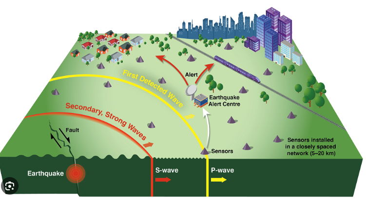
It’s important to keep in mind that an alert is NOT a prediction, but it can provide a few seconds of warning and offers the chance to save lives. Google’s “Android earthquake alert” system has the same premise of an earthquake early warning system—rapidly approximating earthquake magnitude from incoming seismic-wave information, estimating the intensity of shaking expected, and sending an alert. This would all be done on phones rather than on an established seismic network. As Google has stated, their system is supplemental, and not a replacement for government-run earthquake alerting systems, which integrate communication and preparedness.
In the Google model, an Android phone with a built-in accelerometer serves as an earthquake detector. Enough phones near the epicenter would generate the information needed to alert those more distant to the impending shaking. Just like with any type of early warning that exists today, people close to the epicenter would have little to no warning.
One difference between what Google offers and what an integrated early warning system could offer Alaska is that the alert will only appear on Android phones and will work only for those with Earthquake Alerts enabled and who allow Google to track their location. Additionally, phones must be connected to Wi-Fi or have data services on.
The alert system’s utility may be limited by the layout of Alaska’s most hazardous seismic zones, which are primarily offshore. Not many phones will be routinely monitoring the earthquakes that happen there.
Permanent seismic sensors in our regional monitoring networks are high-grade scientific instruments. They provide quality data 24/7 that result in highly accurate estimates of earthquake locations and magnitudes.
In contrast to phones that tend to be clustered in population centers, Alaska’s seismic network is distributed throughout the state, including in remote regions where there is no cell service. This sensor network that comprises several hundred stations will eventually form the backbone of an integrated earthquake early warning system in Alaska, which will rapidly detect impending shaking that initiates far from where people live.
Additionally, the integrated early warning system for the state would not rely primarily on a cellular network. As we have seen in the past, and as recently as last weekend when a broken fiber-optic cable cut off cellular and internet access in Sitka, widespread outages happen in Alaska for a number of reasons.
Hopefully, the new Google earthquake alert will heighten appreciation of what earthquake early warning systems will provide in coming years. Many places around the world have well-integrated earthquake early warning systems, including Canada, Israel, Japan, Mexico and Turkey.
In the U.S., the ShakeAlert system provides warnings in Washington, Oregon and California. In fact, Google works with ShakeAlert in those states, so their announcement about the Android earthquake alert is a step in helping Alaska catch up. The Alaska Earthquake Center has partnered with the U.S. Geological Survey to develop a plan for implementing the ShakeAlert early warning system in the coming years. This system relies on seismic stations, rather than cell phones, to rapidly and precisely measure and send seismic wave arrival information to a data processing center within seconds to determine location and magnitude. The alert would reach every individual, industry, and agency that wants it.