
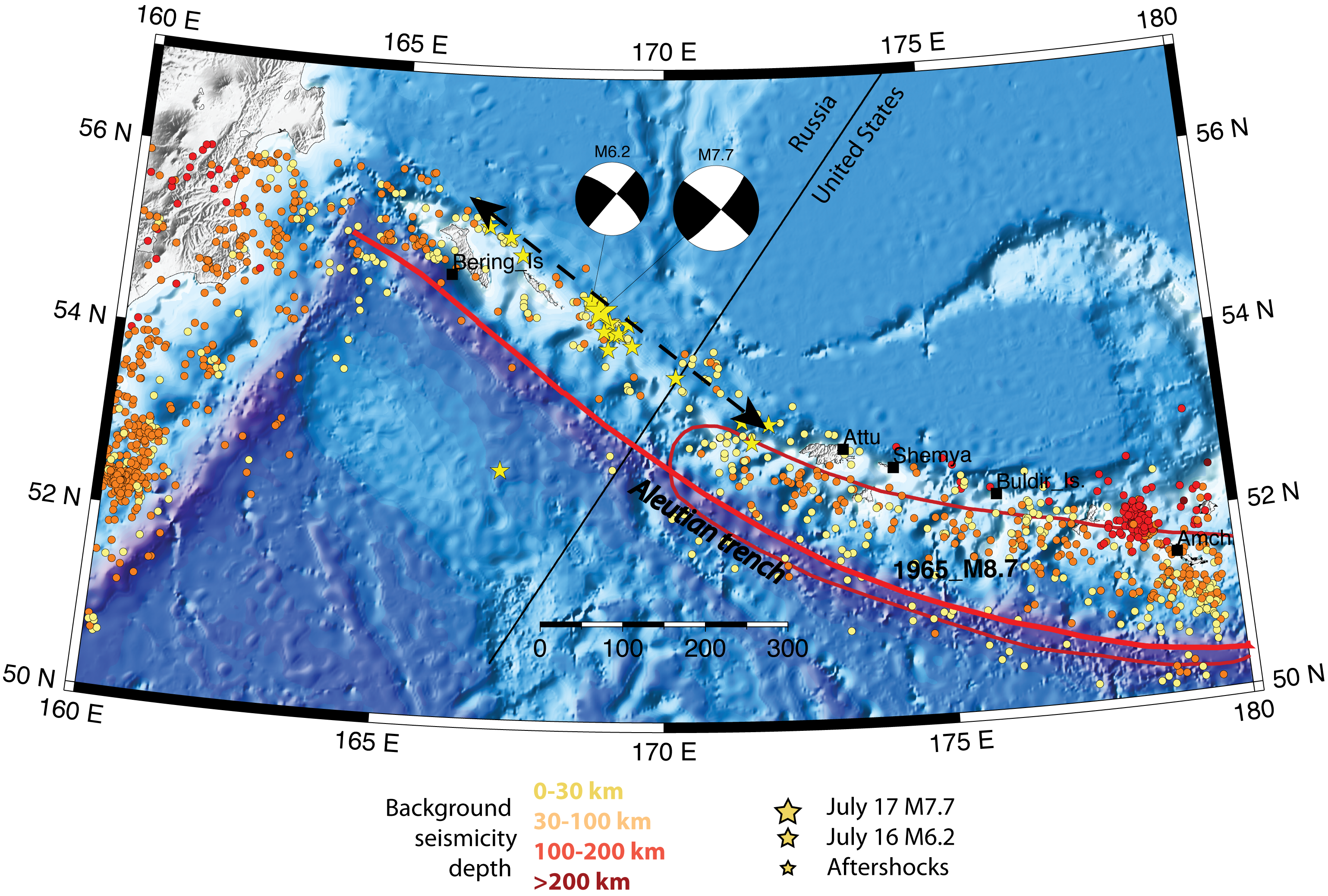


The magnitude 7.7 earthquake on July 17, 2017 in the Komandorskie Islands is the largest of its kind recorded in the region. Due to the region’s remoteness, there is no comprehensive oral or written history describing past seismicity in the area. Moreover, Russian researchers have postulated that earthquakes with sources longer than 150 km are highly improbable in the Komandorskie region. Based on aftershock locations, Monday’s earthquake ruptured at least 300 km. Therefore, this earthquake presents a unique opportunity to study the northwest corner of the Pacific-North American tectonic interactions.
The northwest corner of the Pacific is one of the most tectonically complex areas of the circum-Pacific. Along the westernmost portion of the Aleutian arc, the plate boundary between the North American and Pacific plates changes from oblique subduction to strike-slip motion. This results in diminishment of volcanism and perhaps absence of subduction altogether. The seismicity is predominantly shallow and forms narrow zones delineating crustal blocks. These crustal blocks move west along the large-scale strike-slip fracture zones and eventually collide with the Kamchatka margin. The fault pattern onshore and offshore in the junction area supports this model of collision. South of the Kamchatka-Aleutian junction, the distribution of earthquakes changes and is similar to other subduction zones, with intermediate and deep earthquakes.
The M7.7 earthquake occurred on a strike-slip fault associated with the Bering fracture zone. Based on the early aftershocks (first 24 hours), the rupture propagated bi-laterally northwest towards Kamchatka and southeast towards Attu, crossing the international border between Russia and the United States. The southeast end of the fault rupture is near the northwestern end of the M8.7 1965 Near Islands earthquake. The 1965 earthquake, however, was on a convergent boundary between the subducting Pacific and overriding North American plates.
The July 17 earthquake did not produce notable tsunami waves because it did not create significant vertical motions of the sea floor. The event was felt strongly on Shemya Island in the United States and in Nikol'skoye village in Russia. Aftershocks are expected to continue for at least weeks and most likely months. Due to remotness of the region, only aftershocks with magnitudes 4 and greater can be reliably detected.