Little earthquakes, then an Iliamna, Alaska landslide
November 13, 2026
Ezgi Karasözen
Elisabeth Nadin
Michael West
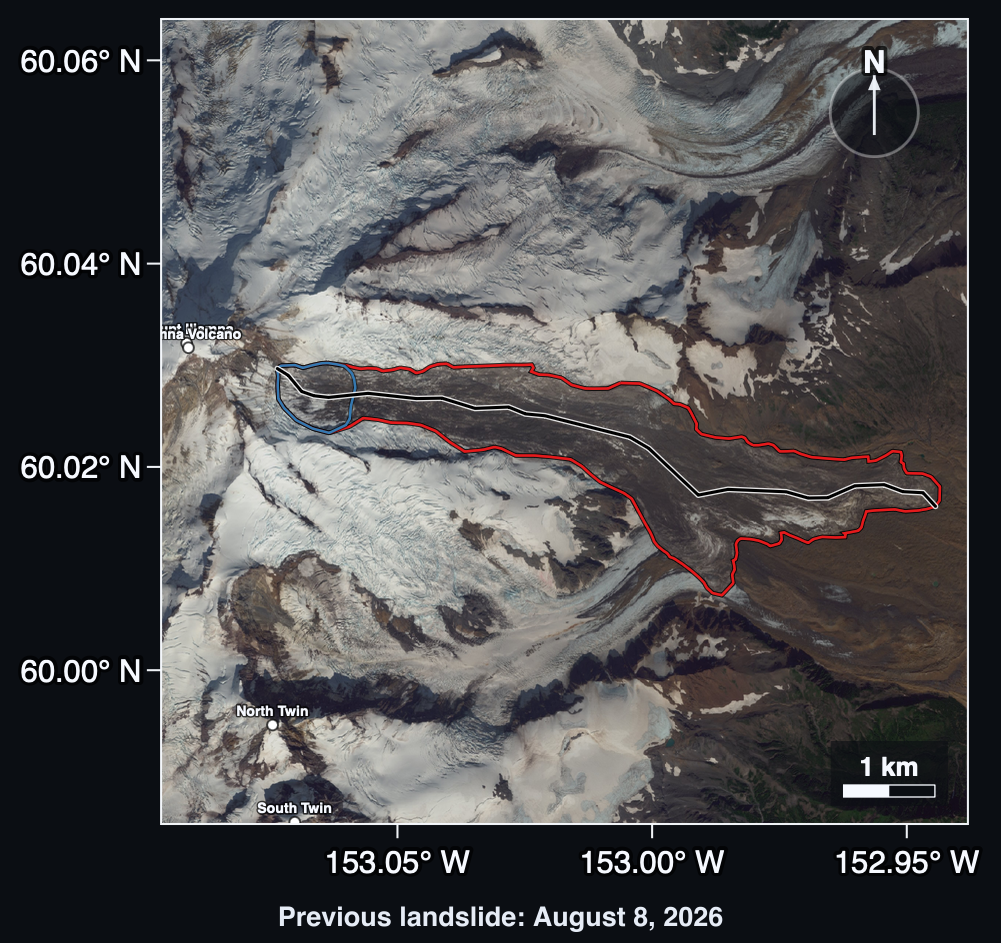
Iliamna Volcano, in the Cook Inlet region of Alaska, has a long history of avalanches and landslides (Figure 1). Some of these have been preceded by sequences of small earthquakes that build up before the slope fails, so scientists keep a close eye on seismic activity there. These precursory sequences may be early clues that a landslide is coming, and one day they could help give advance warning.
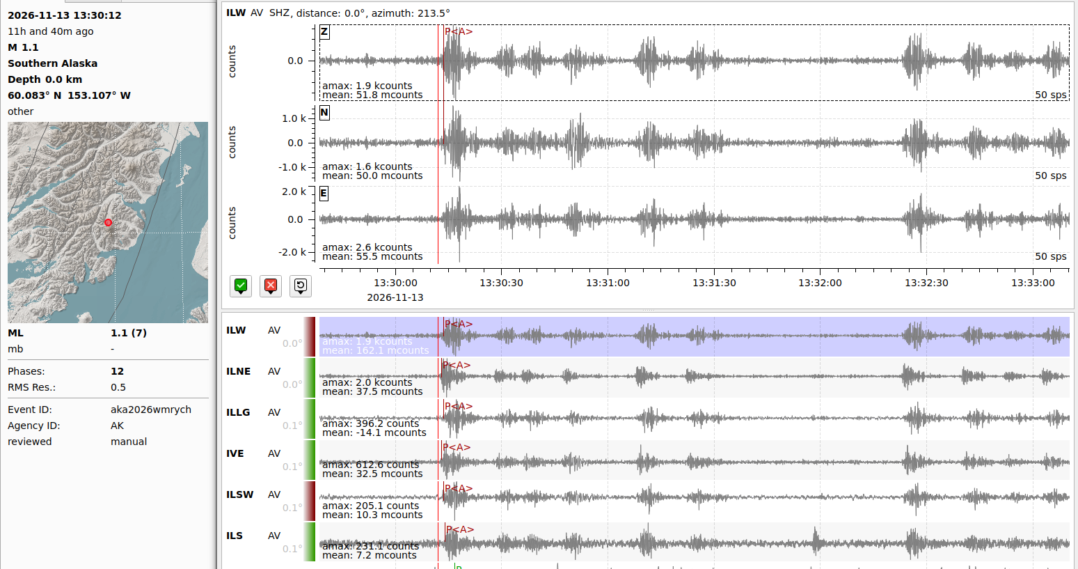
At about 4:30 am local time on Friday, November 13th, a large avalanche–landslide collapsed off Iliamna Volcano. Alaska Earthquake Center's landslide detection system estimates its volume at 1–2 million cubic meters (this is preliminary and may change). Leading up to the landslide, our auto-detection system picked up a heightening staccato of dozens of small earthquakes (Figure 2) that culminated in the relatively longer seismic drone that marks slope failure.
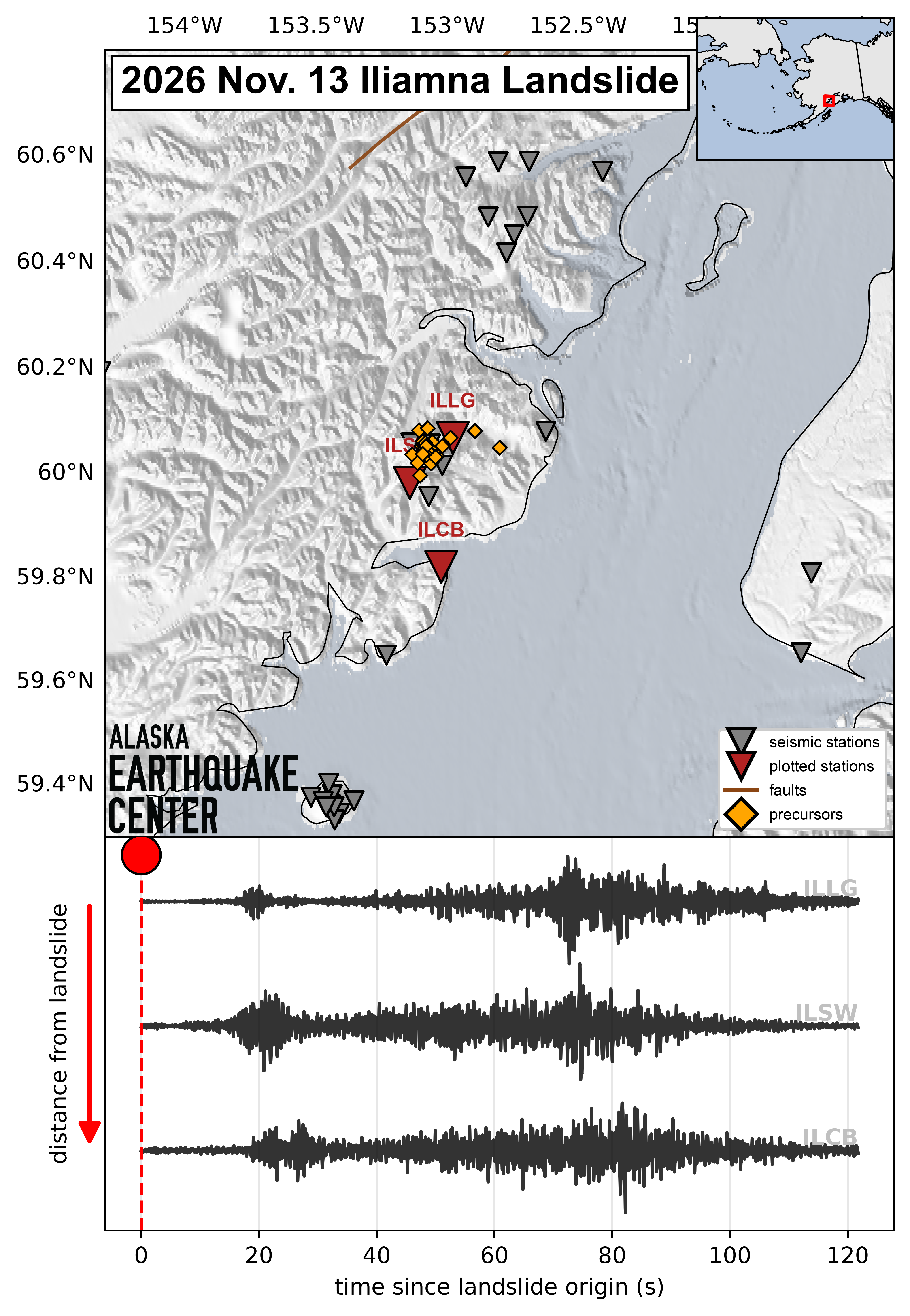
After the August 2025 Tracy Arm Landslide in Alaska, a look back at the seismic data leading up to the landslide revealed thousands of precursory small earthquakes. At Iliamna, the precursors were picked up automatically, as they happened. While the Iliamna landslide thankfully does not impact Alaska communities, the auto-detection of precursors that led to slope failure is a significant step towards the Earthquake Center’s goal of helping to provide any form of early warning (Figure 3).
Searching for landslide signals
Landslide precursors show up as near-identical, small-magnitude earthquakes coming from the same place and escalating over time. Their sizes and pattern suggest that they result from rock masses cracking and slipping, likely building toward slope failure.
Iliamna, an active stratovolcano, produces constant seismic noise. Our analysts are combing through the stream of seismic signals from the area to see which were verifiable precursors. So far they have identified almost a hundred, and will likely discover hundreds more (see video).
Spectrogram before the landslide: Audio rendering of Iliamna landslide and precursors. Precursors sound like rain, while the main event sounds like a door slamming. If you listen closely, you can hear the precursors increase in frequency and amplitude leading up to the event, after which they quickly taper off. Video created using the sonify python package, created by Liam Toney.
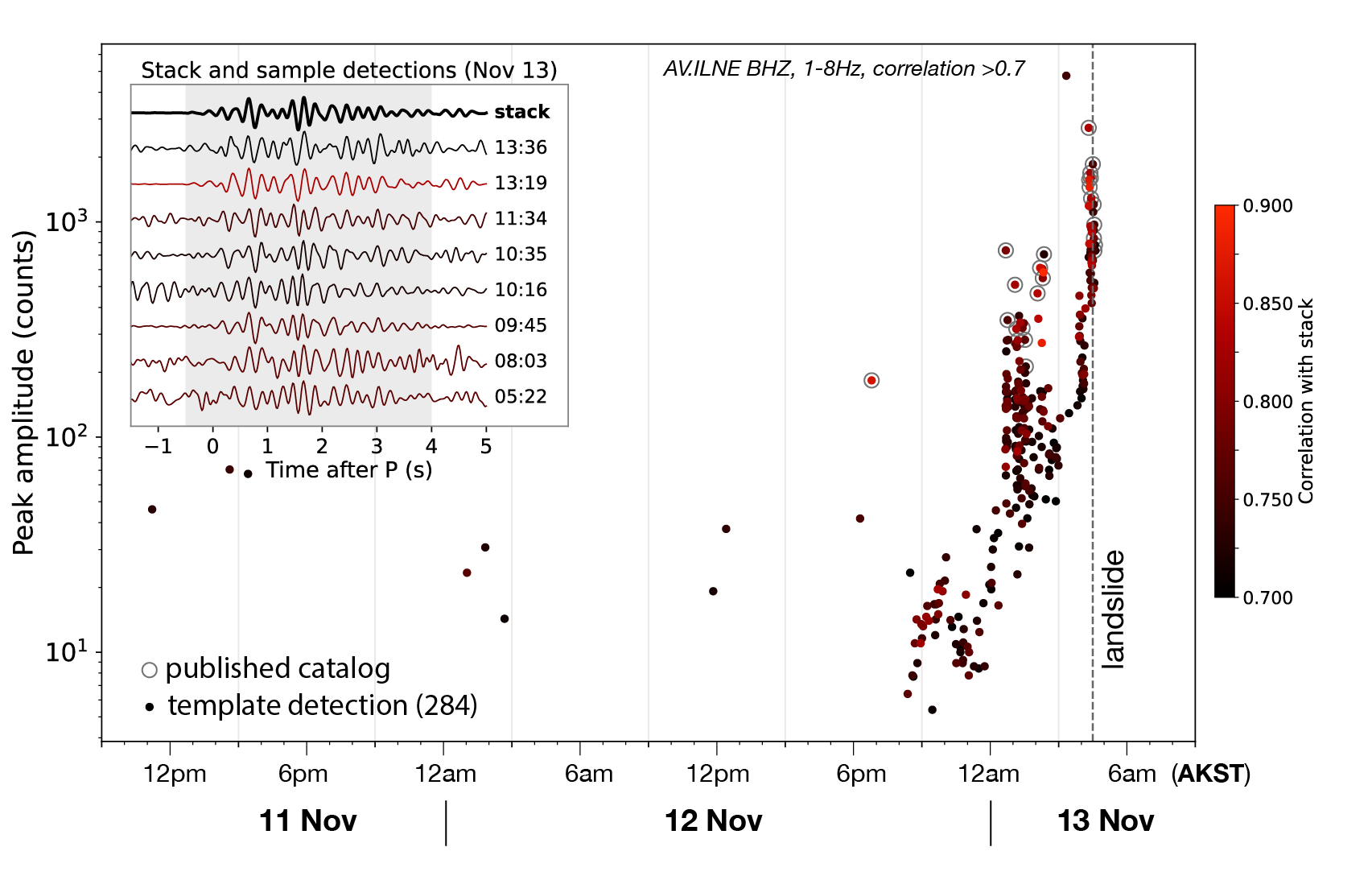
Many of the events we have reviewed in the hours prior to the landslide have very similar seismic waveforms. We use those waveforms to identify earlier precursors that were too small to get picked up by the real-time system. This analysis demonstrates that precursors were prominent at least eight hours prior to the landslide (Fig. 5). This rapid analysis is based on just a single event type, so it is quite possible that precursors began earlier than this.
The main event displays the hallmarkseismic signal of a landslide and was recorded by seismic stations across the region. Though we can often now detect these small earthquakes as they happen, our next step is to learn how to recognize them as precursors in time to flag periods of heightened landslide potential.
For now, we anticipate that satellite imagery in the coming days will allow us to understand what happened on the ground.
We will update information as we receive it.
This story was made possible by Heather McFarlin and Sarah Noel, who reviewed the precursor events, and by Cade Quigley and Ethan Hasenauer, who contributed figures; and Beth Grassi, who edited the story and helped refine the figures.
Landslide monitoring in Alaska is a collaborative and evolving effort between the US Geological Survey, the Alaska Division of Geological and Geophysic Surveys, and the Alaska Earthquake Center.
Figure 1: A prior landslide on August 8, 2026 on Iliamna, one of many on the volcano in recent years. At the time of writing, no satellite imagery is available of the current landslide. This will become available in the days to come when satellite passes and weather align.
Figure 2: Automatic detection of one of the precursor earthquakes, about seven minutes before the landslide. This figure shows roughly three minutes of seismic data recorded at multiple sites operated by the Alaska Volcano Observatory. During this time, there are nine other precursors visible.
Figure 3: Seismic stations and sample waveforms of the Nov. 13 landslide. The gold triangles show events that occurred before the main slide. The bottom panel shows the seismic record of the landslide on three nearby seismometers, demonstrating that the event unfolded over nearly two minutes.
Figure 4:Time history of precursors: One family of small repeating earthquakes demonstrates that precursors were occurring at least eight hours prior to the landslide. The vertical axis demonstrates how these events grew more energetic in the hours before the failure. The inset figure shows seismic waveforms from a sample of precursors that matched the template (in black). Shades of red demonstrate how well these precursors correlate with the template.