
**Technical details: Plot shows vertical component broadband seismograms that have been trace normalized and bandpass filtered on 20-100s.


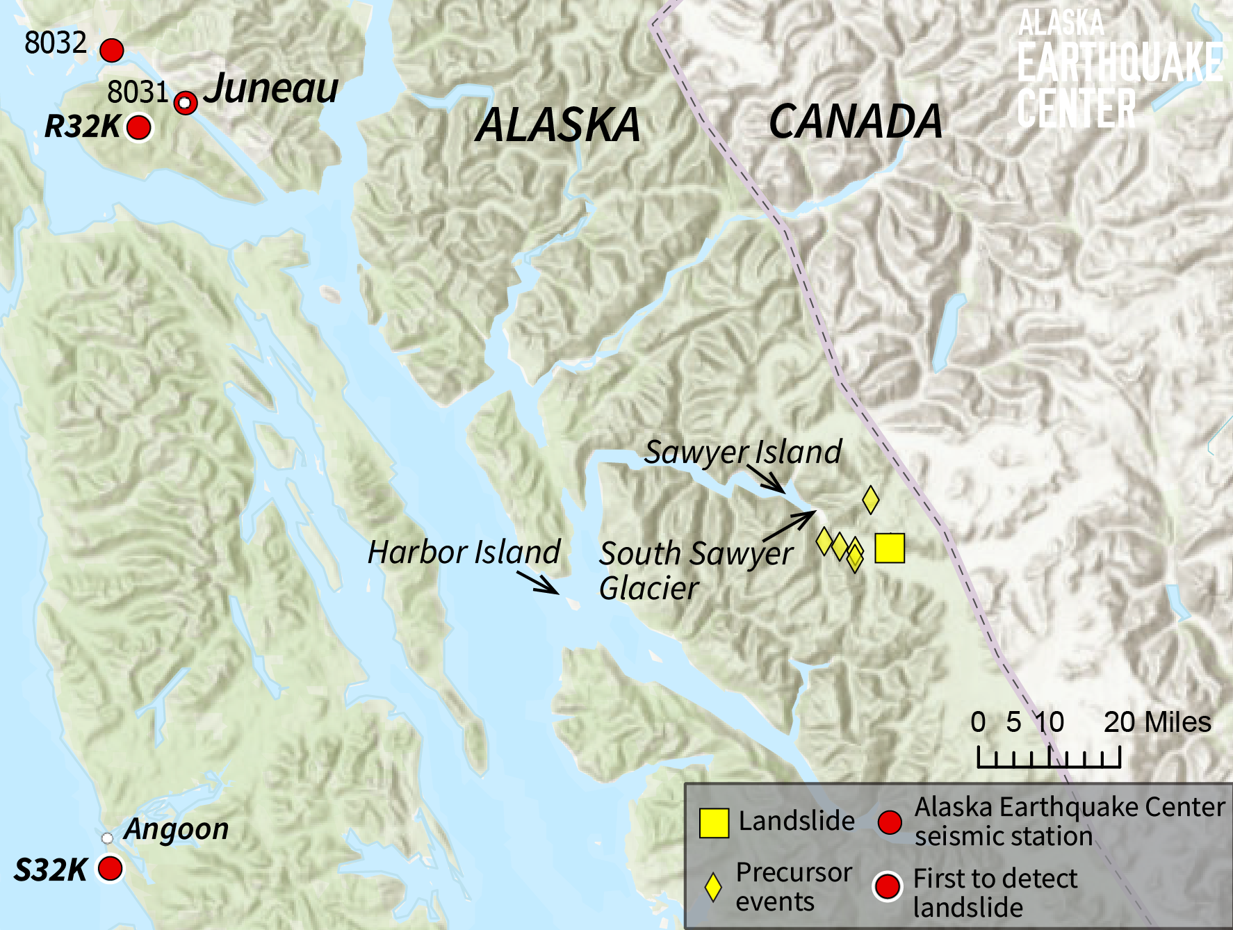
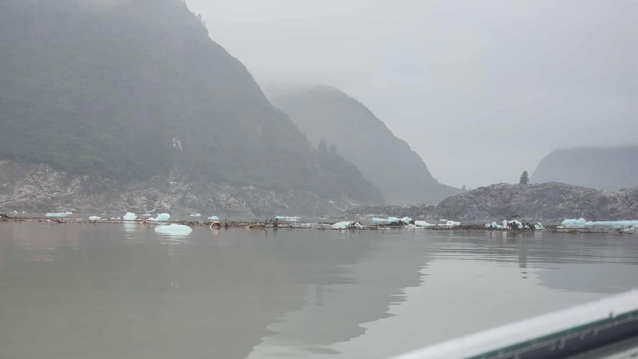
Early on August 10, 2025 the Earthquake Center received reports from people out boating of a mysterious local tsunami in the Endicott Arm area of Southeast Alaska, with waves of 10–15 ft near Harbor Island (Figure 1). The National Park Service reported a run-up of at least 100 ft at Sawyer Island, with vegetation stripped from the slopes. (Figure 2)
Three kayakers camping at Harbor Island lost most of their gear, but made it safely back to Juneau. Nick Heilgeist, one of the kayakers, said “We were woken up somewhere 5:45-6 by the water rushing by 1 ft from our tent back in the woods.” Heilgeist said it was nearly low tide. They were camped well above the expected 17-foot high tide, so he estimated the wave probably came about 20 vertical feet.
The National Weather Service office in Juneau reported no known injuries or infrastructure impacts. The National Tsunami Warning Center reported the highest wave as 14 inches (35 cm) on the Juneau tide gauge, about 60 miles away.
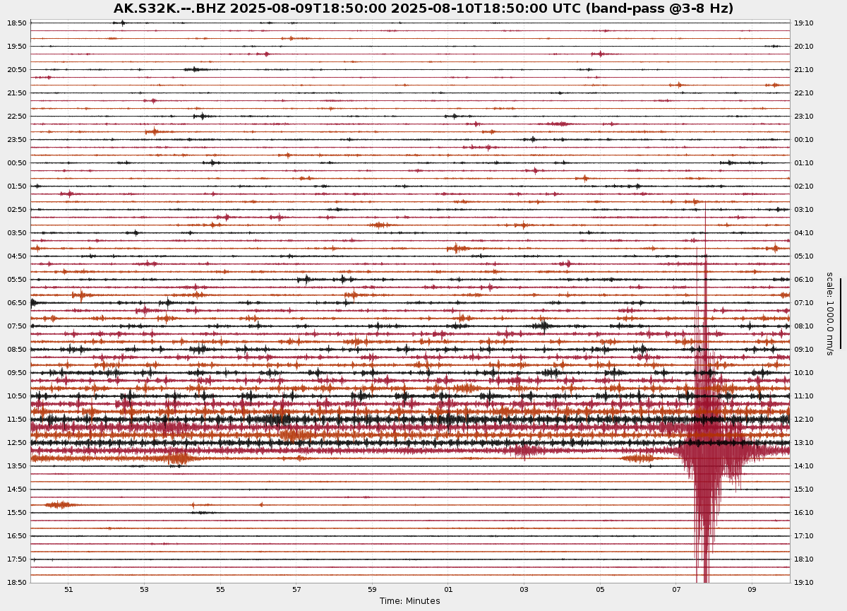
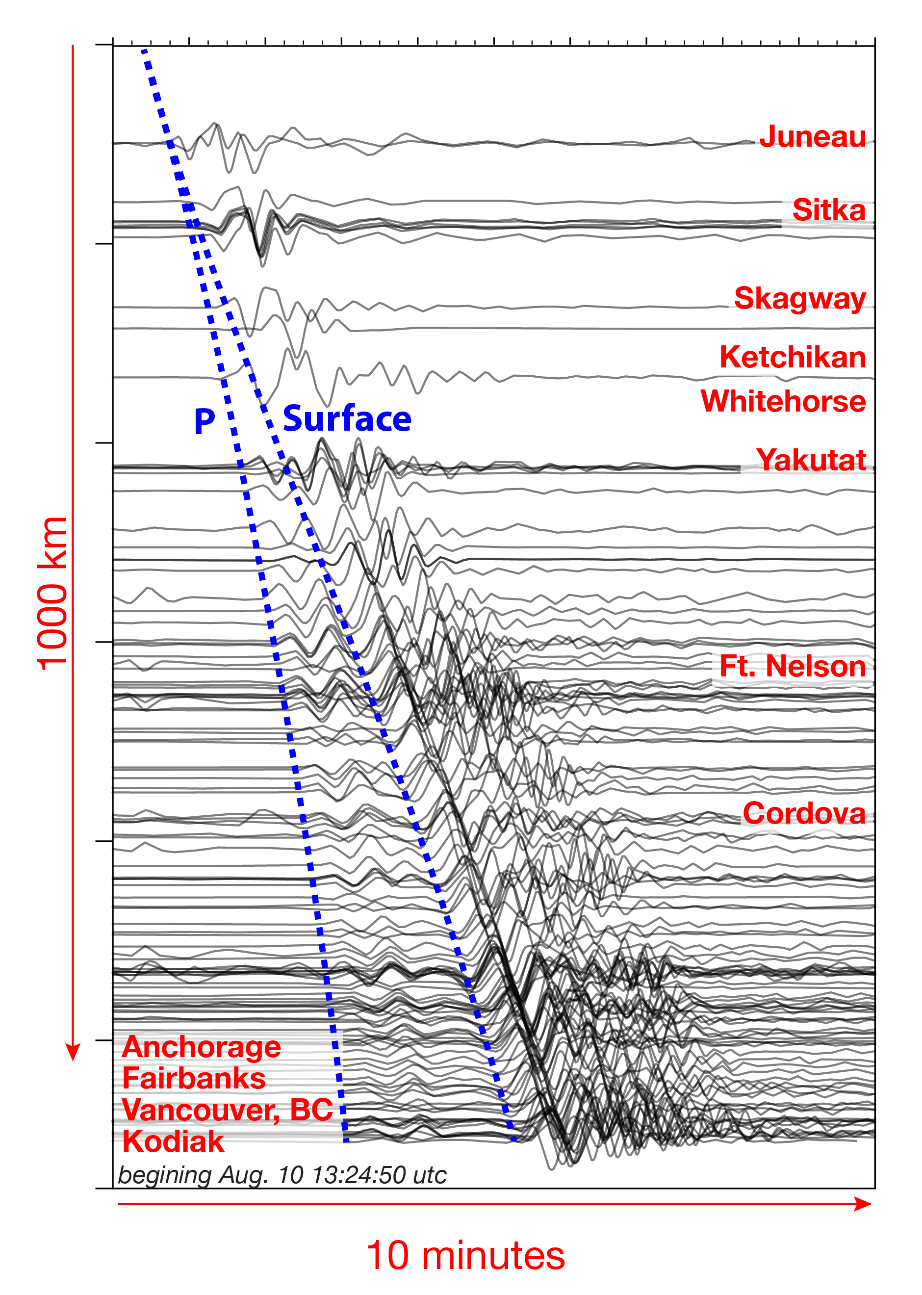
That same morning, Ezgi Karasözen, one of the Earthquake Center’s research scientists involved in developing tools to detect landslides, jumped on the mystery. There was no earthquake detected in the area. The region is outside of the Earthquake Center’s recently expanded landslide detection coverage, so there was no automatic detection. Karasözen applied our landslide characterization algorithm on the data from Southeast Alaska seismic stations (Figures 3-5).
What she found in the seismic record was a massive landslide in the same area as the tsunami. “Our initial estimate placed the source near South Sawyer Glacier, with a very large volume, possibly larger than 100 million cubic meters,” said Karasözen. There is some uncertainty of the actual volume, but it will take several days at least to ground-truth the event, and these are the first, rapid estimates of its size.“Our goal with these initial estimates is to get a quick ballpark estimate of what’s going on. I’m sure there will be lots of detailed volume estimates coming from various studies, but it will take time,”said Karasözen.
This is potentially the largest landslide and tsunami in Alaska since Taan Fjord in 2015. The landslide signal was detected by nearby seismic stations as well as stations well beyond 600 miles (1,000 km) away, which supports the interpretation of a large event.
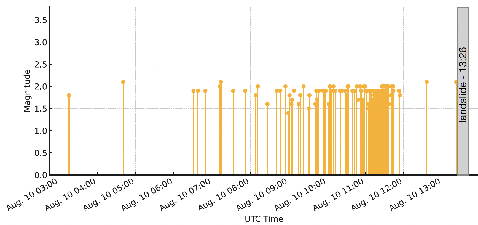
This event is extremely interesting scientifically. The landslide was preceded by hours of small magnitude 1-2 earthquakes leading up to the slide. These were first recognized by Western Washington professor Jackie Caplan-Auerbach, who previously held a postdoc position at UAF. The precursors are very clear in the ~18 hrs prior to the slide and likely well before that. Our seismic data analysts have analyzed about a hundred of these precursors and they emanate from the same area as the landslide (Fig. 1).
We continue to work with the US Geological Survey, the National Tsunami Warning Center, The Alaska Division of Geological and Geophysical Surveys, and local authorities to refine location, size, and potential hazard assessments.
Visit our significant event page for the 2025 Tracy Arm Landslide for updates, new graphics and materials.