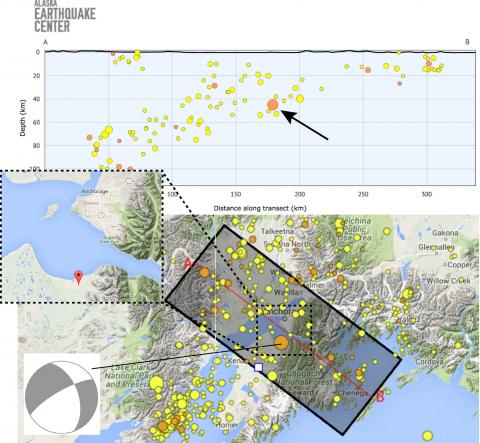
At 1:41 Monday morning, many in the Anchorage and Kenai regions woke to the shaking of a magnitude 4.2 earthquake centered 13 miles west of Hope. The earthquake was not widely felt, but it was felt by many because it occurred so near to several cities and towns. A number of residents commenting in our Facebook group described it as a sharp jolt.
It was natural for people to think think they were feeling yet another aftershock from the magnitude 7.1 Iniskin quake, but that was not the case. Monday morning's earthquake originated about 130 miles closer to Anchorage and was nearly 50 miles shallower than the M7.1.
The figure at right aggregates a few facts about the M4.2, which appears to have occurred in the subducting slab. The lower map shows where it was centered with an inset relative to Anchorage. The ongoing Iniskin aftershocks can be seen to the west of Homer.
The moment tensor, provided by Vipul Silwal, shows relative extension in the WNW-ESE direction. Along with the depth, this is good evidence the earthquake did not occur on the interface between the plates. The top panel shows a cross section with the last two weeks of earthquakes (the shaded box). The sloping cloud of earthquakes maps out the down-going Pacific Plate, again illustrating that this earthquake likely occurred well below the plate interface.


