
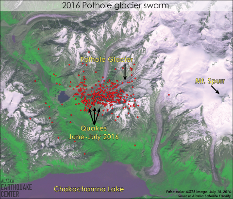


Many of you have noticed the significant swarm of small quakes occurring about 8 miles west of Mt. Spurr. Since June 11, there have been hundreds of earthquake-like events with magnitudes up to 2.4. As of the beginning of August, there have been nearly 100 quakes exceeded magnitude 2, and many hundreds of smaller quakes. The numerous events have been hard to miss if you are in the habit of perusing the recent earthquakes map. Together with the Alaska Volcano Observatory we have been watching these carefully.
It is unlikely that these are actual earthquakes occurring on faults in the earth. More likely, this ground shaking is coming from one of the nearby glaciers. Glaciers are a common source of small quakes in Alaska. This time of year we record shaking from glaciers everyday in the areas of Prince William Sound, Icy Bay, Hubbard glacier and elsewhere. Most of the glacier quakes, or ice quakes, are caused by large icebergs calving into the open water. Some of these can be detected a couple of hundred miles away. However, glaciers also create seismic events (a fancy term for ground shaking) through crevassing, grinding against underlying rock, and toppling pieces off of steep glacier ice falls. Glacier quakes large enough to be recorded on the statewide seismic network are less common in the Cook Inlet region, but do happen every year.
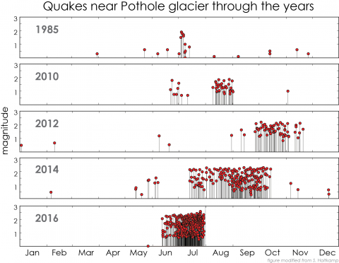
This particular swarm is occurring near the Pothole glacier in relatively steep terrain (see map). Though the location of these quakes scatter over a few miles, all signs suggest they are actually occurring at a single location. The location near an active glacial valley is the first clue that they may be caused by ice. Looking back through the records, it turns out that similar swarms have occurred in this same location as far back, at least, as 1985 (figure 2). Recent swarms have occurred in 2010, 2012, and 2014 though this year's swarm appears to be the most vigorous to date. Note that all of these swarms have started in the warm months between June and September. This is a second suggestion that they are caused by ice. Glaciers move more when the weather is warm, as melt water and rain lubricate and float the bed of the glacier.
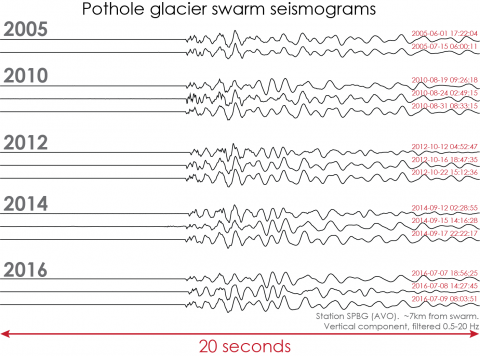
The seismograms in Figure 3 show that these quakes are virtually identical year to year. This means the process that is causing these quakes is long-lived and repeats itself. The seismograms demonstrate that this process can go on hiatus for a couple of years and then abruptly turn back on. Each time however the quakes never seem to go above about magnitude 2.4. The repetitive nature of these quakes over years is another factor more consistent with a glacier source than other explanations. Lastly, seismologists will note that these signals are lower frequency than typical tectonic earthquakes. Technical explanations include possible low stress drop and strong surface wave generation---both consistent with an ice source.
Small earthquakes like these do no damage. We watch them carefully however. Sometimes small earthquakes map out the location of larger, potentially destructive faults. Other times small earthquakes can warn of a possible volcanic eruption. In this case, all signs suggest it is just another one of Alaska’s noisy glaciers.