
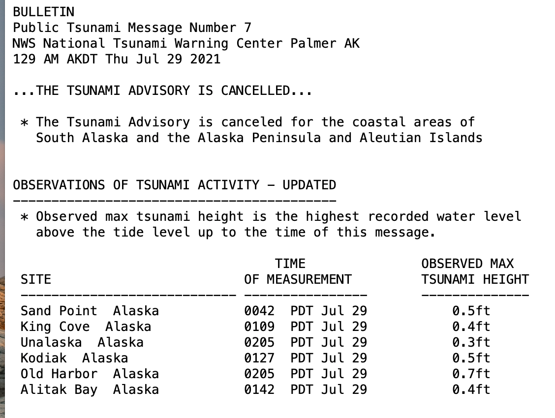


On July 28, 2021 tsunami warning sirens sounded in coastal towns along southern Alaska and the Alaska Peninsula. A M8.2 earthquake 70 miles offshore from Chignik prompted the National Tsunami Warning Center to issue a tsunami warning for much of coastal Alaska. Several communities issued evacuations, including Chignik Bay, Chignik Lagoon, City of Kodiak, False Pass, Homer, King Cove, Nelson Lagoon, Old Harbor, Sand Point, Seward, and Unalaska. The Chignik tsunami warning was cancelled a few hours after the earthquake.
Fortunately, the tsunami caused by the earthquake was smaller than might be anticipated for an earthquake of this size. Many factors can influence tsunami height, including underwater landslides or earthquake depth. At the moment, we have no data about underwater landslides triggered by the Chignik earthquake. The depth of the earthquake, about 20 miles, meant there was not much movement on the surface of the ocean floor. The resulting initial waves were under a foot high (see Figure 1). A shallower earthquake could have resulted in more uplift of the ocean floor, generating a much larger tsunami. For example, in 2009 a M8.1 earthquake in Samoa that was 10 miles deep generated a wave height of approximately 9 feet, about the height of a one-story building. The tsunami caused a large amount of damage and killed 189 people. In 2014, a M8.2 in Chile at a depth of about 15 miles generated a tsunami of approximately 7 feet, causing widespread damage.
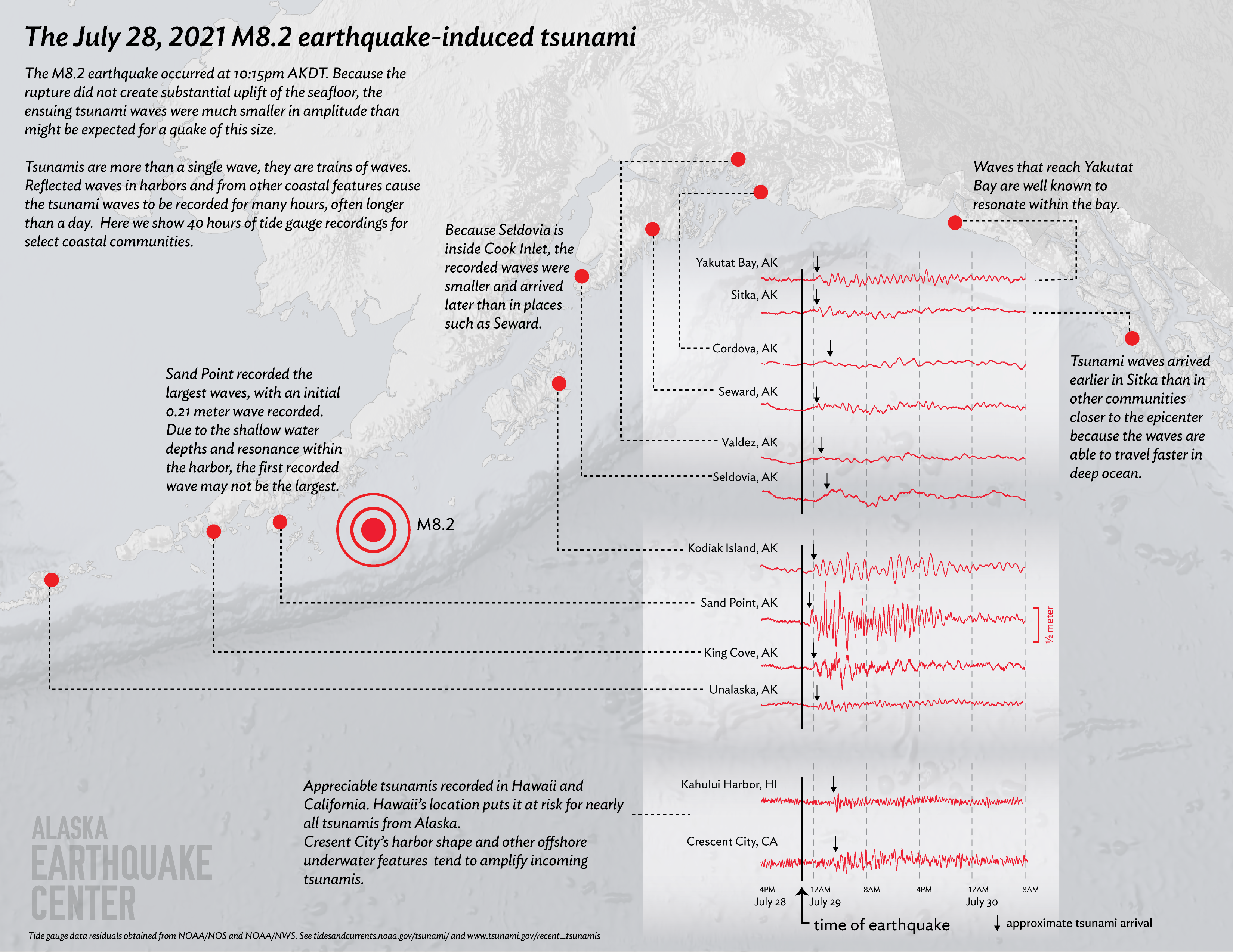
Measuring the initial wave of a tsunami doesn’t tell the whole story. Tsunamis are trains of waves that arrive over the course of hours, and often over a full day. Initial waves are rarely the largest. Looking at NOAA tide gauge records for this event (Figure 2) can give us valuable insight into how larger tsunamis might behave in different communities.
The tide gauge records for Sand Point and King Cove in Figure 2 clearly show larger waves arriving after the initial wave. These two communities had the closest available tide gauges to the earthquake source. In Sand Point, shallow water and harbor resonance (when energy bounces back and forth in an enclosed area) caused wave heights to increase in later waves.
The location of a community and the underwater landscape surrounding it affect how the tsunami manifests locally. In deep ocean, tsunami waves may travel 500 mph or more, faster than a jet plane. Shallow water slows the waves down. For example, because of Seldovia’s sheltered location inside Cook Inlet the tide gauge there recorded smaller, later waves than what were recorded in Cordova and Seward, which are more exposed to deep water. Waves arrived in Sitka earlier than in other communities closer to the earthquake origin, because the wave speed across the deep waters of the Gulf of Alaska is faster than in the shallow waters of the continental shelf.
Yakutat’s proximity to the deep Gulf of Alaska allowed waves to reach the coast soon after the earthquake. The waves then resonated within the enclosed bay, causing the repetitive pattern seen in Figure 2.
Tsunami waves were recorded in Kahului Harbor, HI and Crescent City, CA. Hawaii’s location in the middle of deep ocean puts it at risk from nearly all tsunamis originating in Alaska. Crescent City, CA, has underwater landscape features and a harbor orientation and shape that amplify incoming tsunami waves. A tsunami from the 1964 M9.2 earthquake in Alaska killed 11 people, damaged hundreds of homes, and destroyed 30 square blocks downtown in Crescent City.
When a large earthquake such as the Chignik M8.2 occurs, but we avoid the danger of a big tsunami, it provides an unparalleled learning opportunity for everyone. How did the tsunami spread and how did it behave in each community? How quickly and successfully did your community evacuate? Is there room for improvement? In the midst of such an event, tsunami warnings must happen within minutes, whereas the information about the earthquake mechanism and depth that trigger the tsunami take much longer to decipher. The Alaska Earthquake Center works to provide tools for communities to understand and prepare for tsunami hazards. Knowing your tsunami risk before disaster hits could save your life. Explore the online tool at tsunami.alaska.edu to determine whether your house, workplace, or school is in the inundation/flood zone. Check with your local agencies about evacuation routes and safety ahead of time.