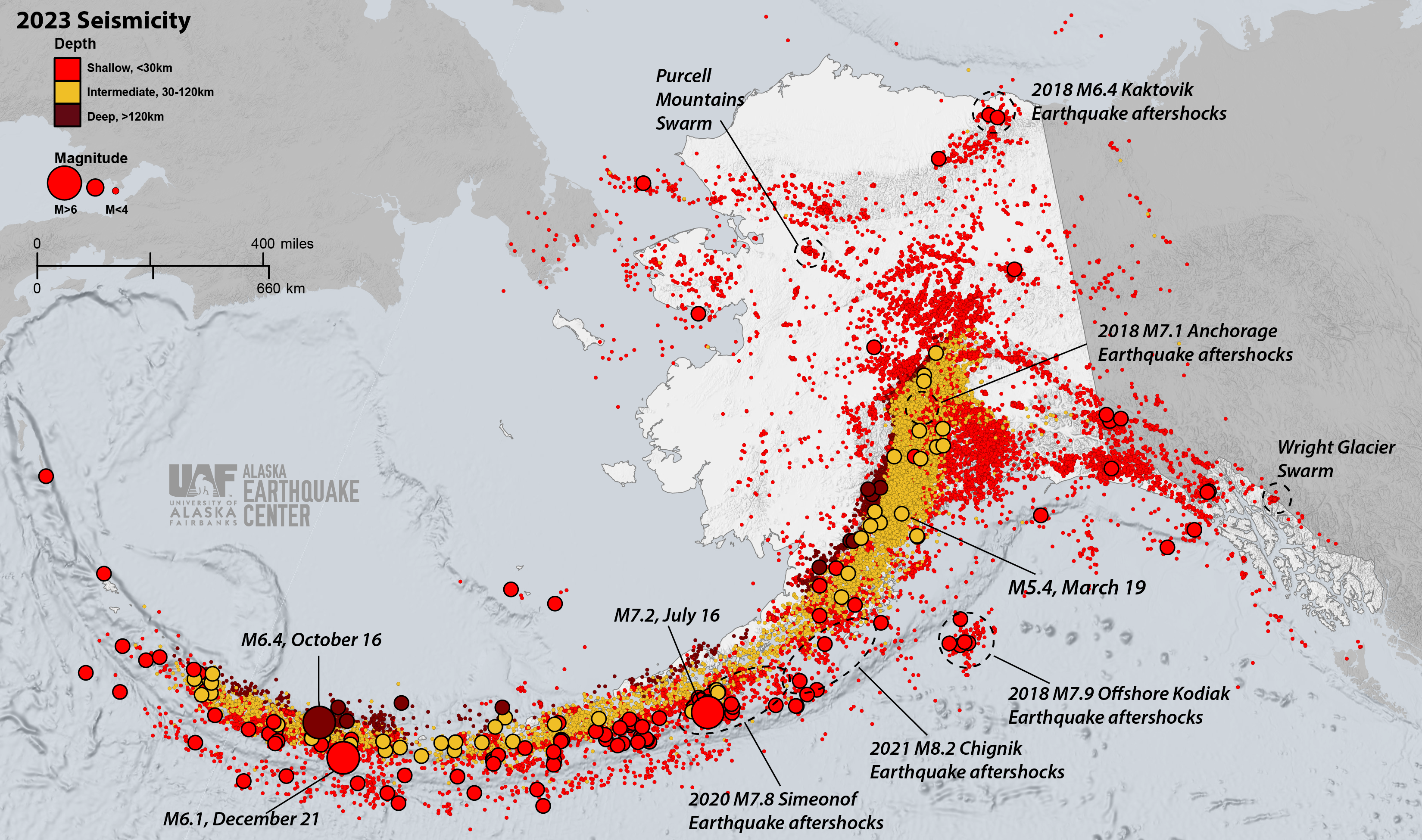
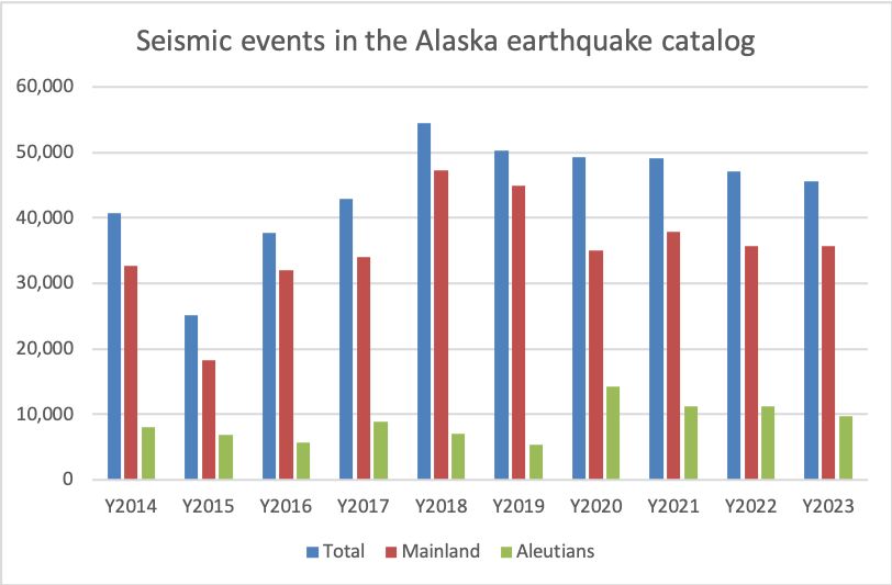
When Alaska has less than 50,000 earthquakes in a given year, we consider it quiet. 2023 was a quiet year for Alaska, with the Alaska Earthquake Center reporting 45,546 seismic events in Alaska and neighboring regions (Figure 1). This is ~1,500 less than in 2022, and about 8,900 less than the record-breaking 2018 (Figure 2).
Largest Earthquake: July 16, magnitude 7.2 in the Alaska Peninsula region. While we informally referred to it as the “Sand Point Earthquake,” we consider it a late aftershock of the 2020 M7.8 Simeonof Earthquake.
The next-largest events were the October 16 M6.4 and December 21 M6.1 earthquakes in the Andreanof Islands region of the Aleutian Islands.
The largest earthquake in mainland Alaska was a magnitude 5.4 in the lower Cook Inlet region on March 19.
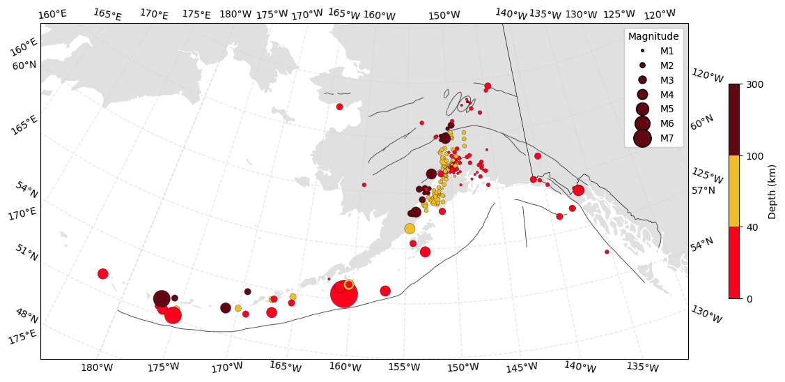
A total of 225 earthquakes were reported as felt, mostly in Southcentral Alaska communities (Figure 3). The largest number of DYFI (Did You Feel It) responses—2,191—came from a M4.5 earthquake that occurred July 3 at 14:47:29 UTC (5:47 am Alaska time on July 4), about 2 miles southwest of Eagle River in the Cook Inlet region.
Aftershocks continue, albeit at a slower rate, within the 2018 M7.1 Anchorage, 2018 M6.4 Kaktovik, 2018 M7.9 Offshore Kodiak, 2020 M7.8 Simeonof, and 2021 M8.2 Chignik aftershock sequences. The Purcell Mountains earthquake swarm and the Wright Glacier cluster northeast of Juneau also continue to be active.
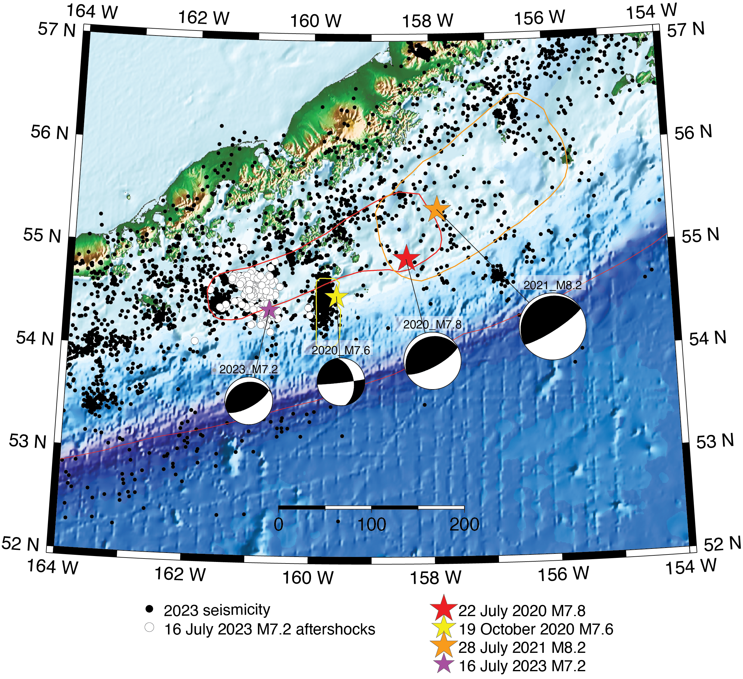
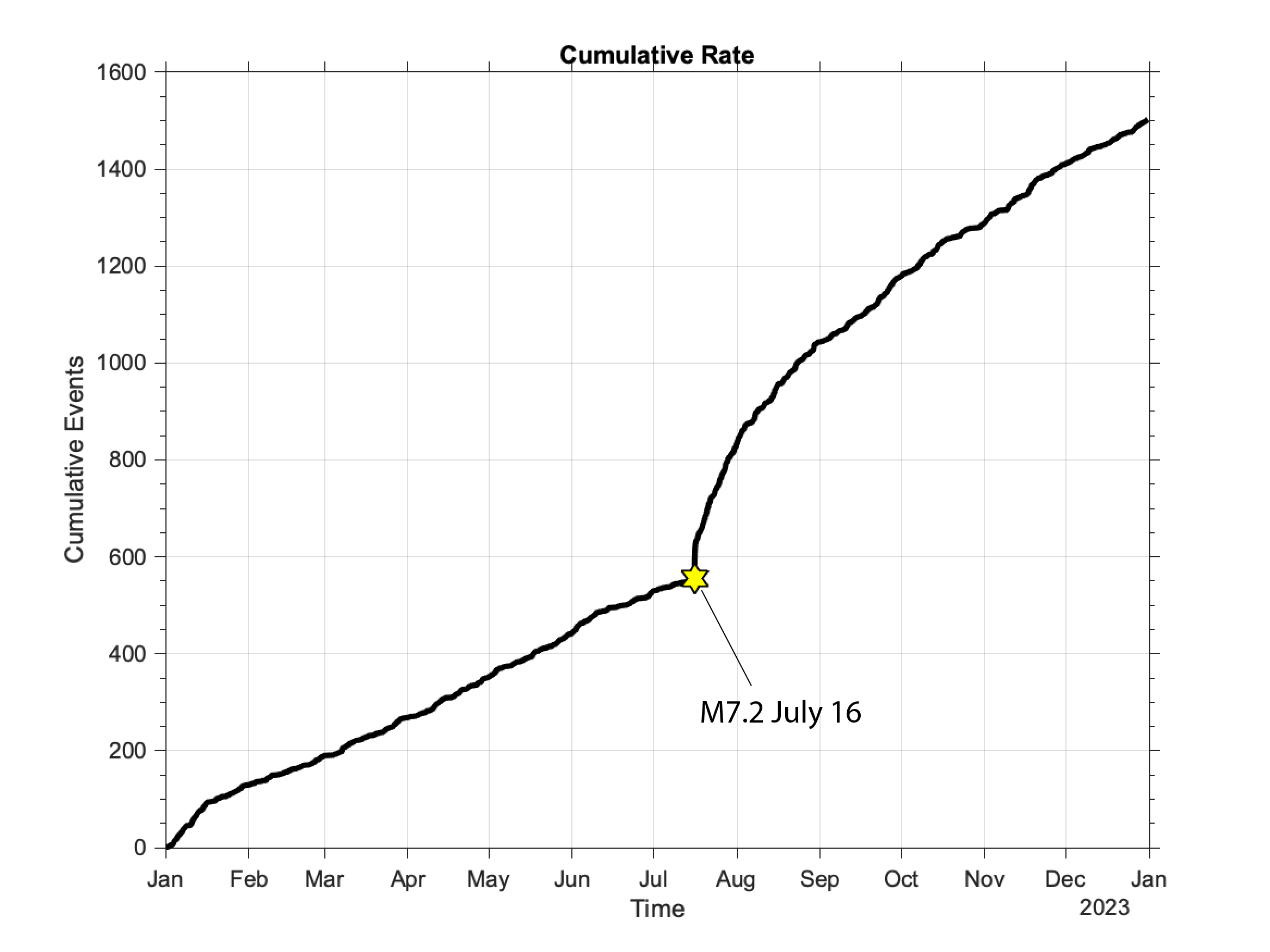
The Simeonof Earthquake produced the most aftershocks in 2023—1,503 were reported with magnitudes between 1.1 and 7.2 (Figures 4 & 5). About 20 of these had magnitudes above 4.0. The largest aftershock, a magnitude 7.2, occurred on July 16 south of Sand Point and within the western segment of the M7.8 aftershock region. While the rate of the Simeonof aftershocks continued to decline in the first half of 2023, it picked up after the M7.2 event, which generated its own aftershock sequence. This aftershock was felt throughout the Alaska Peninsula and the eastern Aleutian Islands. It prompted tsunami evacuations, and generated an observed tsunami of 0.5 feet in both King Cove and Sand Point. We expect the Simeonof aftershock sequence to continue in 2024.
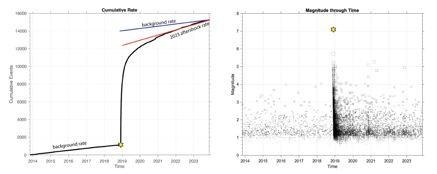
November 30, 2023 marked the fifth anniversary of the M7.1 Anchorage Earthquake. Aftershocks continued at an average pace of around 11 per week, which is about 20% less than in 2022. The largest aftershock was a magnitude 3.9 on April 3. Approximately 585 aftershocks were reported in 2023, bringing the total count for the sequence to more than 14,000 aftershocks. About 17 of these aftershocks were reported as felt in 2023. While the original estimates for the duration of this aftershock sequence were on the order of 2 to 2.5 years, the seismicity rate remains elevated compared to the background rate prior to the M7.1 mainshock (Figure 6). We expect this sequence to continue at a decreasing rate in 2024.
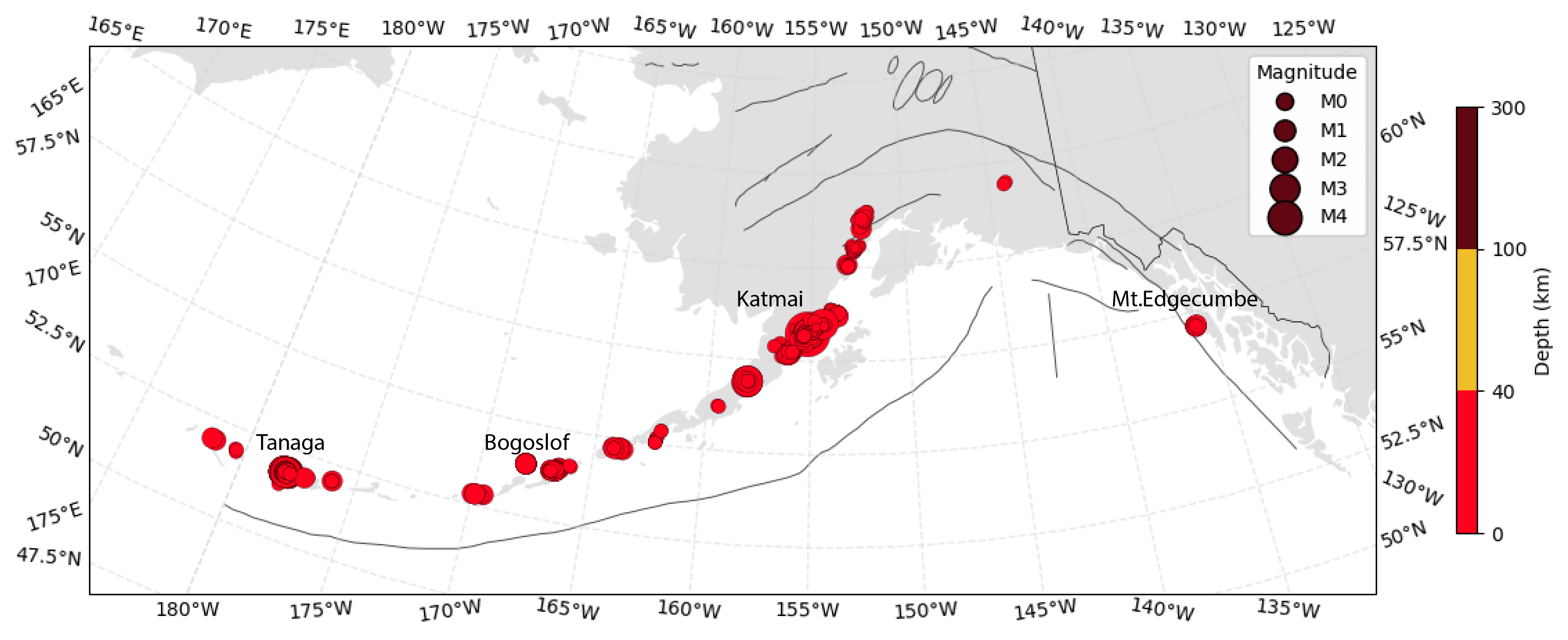
2023 saw an increase in seismic activity associated with volcanic processes (Figure 7). We characterized 2,626 quakes as associated with volcanic activity (M=0.6 to 4.3), which is four times as many as in 2022. The first and most energetic sequence began in February and continued into March under the Tanaga–Takawangha volcanic complex in the central Aleutians. There were about 900 earthquakes reported in total, with six of them having magnitudes between M4.0 and M4.4. About 1,200 events were associated with the Katmai volcanic field, with magnitudes up to 4.2 and activity continuing throughout the year. An unusual, but short-lived, swarm associated with Bogoslof volcano occurred in late October. Bogoslof’s most recent eruption was in 2017. Most events were fairly small, with a few reaching M2.8. About a dozen earthquakes (M1.3–2.4) were recorded under Mt. Edgecumbe in Southeast Alaska in May and June. The Alaska Volcano Observatory installed a local monitoring network at this volcano in 2022, following observations of ground deformation consistent with the inflation of a magma body under the volcano. Seismic events were recorded at several other volcanoes as well.
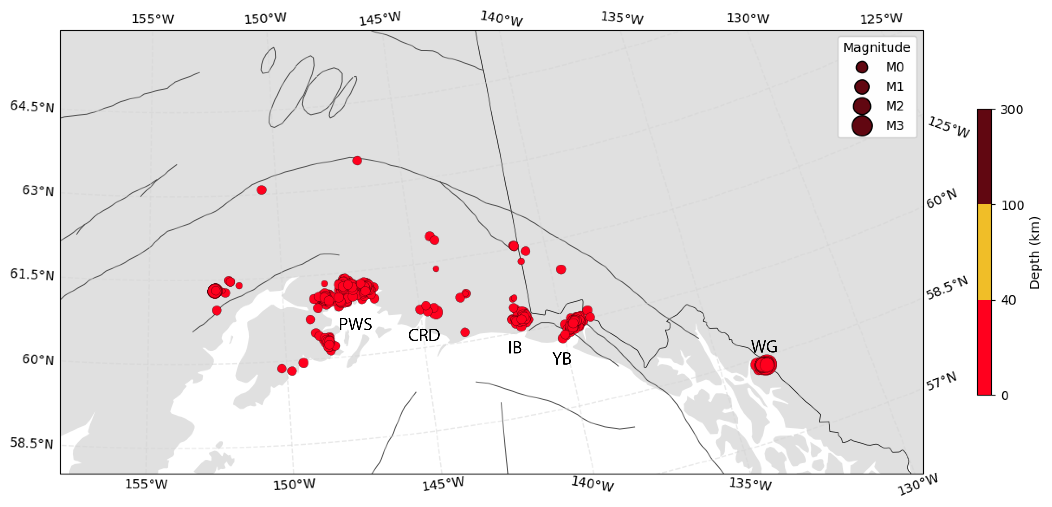
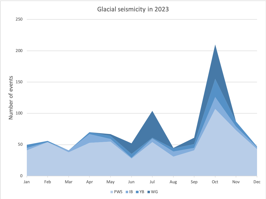
Alaska, due to its large expanse of glaciated areas, has a large potential for recording glacial seismicity. In 2023, we reported 1,028 glacial quakes, ranging in magnitude up to M3.1. Most glacial activity happens where glaciers end at the water; these are tidewater glaciers and they are common in the Prince William Sound region, Icy Bay, and Yakutat Bay (Figure 8). Their “icequake” activity follows seasonal variability and peaks at different times in different areas (Figure 9). This year, glacial seismic activity in Prince William Sound peaked in October–November, which is later in the season than usual.
We continued to record events in a cluster under Wright Glacier, which is about 40 miles northeast of Juneau. The 2023 activity started in late May and had two different episodes of elevated rates in July and October. Activity in 2023 continued much later into the season than observed in 2020 or 2021, but similar to 2022. Overall, seismic activity in this cluster was only half the rate of those observed in 2022 or 2021. Periodic seismicity in this area has been observed since the 1970s, with event rates usually peaking in summer and early fall. These quakes tend to cluster near the Speel River, where it drains glaciated areas of Mt. Ogden. The levels of activity, however, are not the same every year. Seismicity rates observed in 2020–2022, for example, have not been observed since 2011–2012.
Ten reported seismic events were classified as landslides (M1.1–3.0), most based on visual analysis of the seismic waveforms, and some with ground confirmations. Landslides have a seismic signal that is distinct from earthquakes, icequakes, and explosions.
On September 13 at 18:06 AKDT, a large landslide occurred near Peters Dome, on the north side of Denali Peak in Denali National Park. This event was ground-truthed the following day by National Park Service officials during a flyover. Preliminary estimates give a volume of approximately 4–6 million cubic meters of displaced rock and soil. The runout of this event—how far the landslide traveled—was estimated during the flyover to be approximately 3 km. The estimated equivalent earthquake magnitude for this event is 2.6. Smaller landslides were recorded over the next few days in the area of the initial large landslide.
Another large landslide occurred on September 13, at 11:19 am AKDT, near Yakutat Bay/Lucia Glacier. The preliminary volume of this landslide is estimated to be approximately 10 million cubic meters. The estimated equivalent earthquake magnitude is 3.0. This event was ground-truthed using Planet.com imagery.


