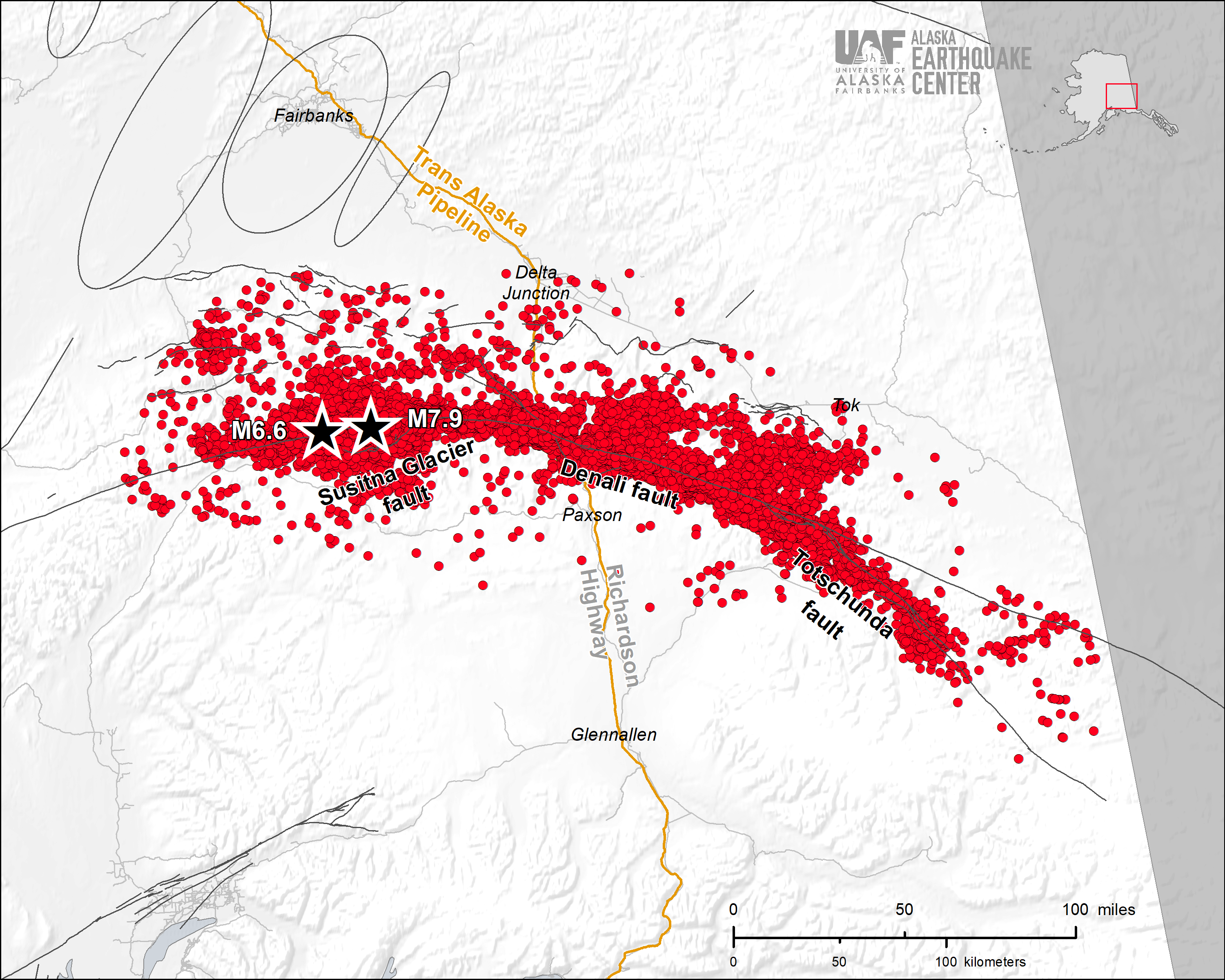
On November 3, 2002, a magnitude 7.9 earthquake shook Interior Alaska for two to three minutes, the largest inland earthquake in North America in 150 years. The Denali Fault Earthquake ruptured 210 miles in roughly 90 seconds. The earthquake initiated at a depth of about 2.6 miles (4 km), 45 miles east of Denali National Park on the previously unrecognized Susitna Glacier Thrust Fault. The fault rupture then traveled eastward along the main Denali Fault trace until it took an even more easterly turn onto the smaller Totschunda Fault. Because the earthquake was so shallow, it had visible ground surface effects: it fractured rock and glaciers and displaced roads and streams, with a maximum sideways movement of about 29 feet (~9 m) in places.
The Denali Fault Earthquake occurred in a region of sparsely scattered communities. Fortunately, this resulted in no fatalities and limited damage. Hardest hit were the villages of Mentasta and Northway, located near the eastern edge of the rupture zone. The runway at the Northway airport was badly damaged.
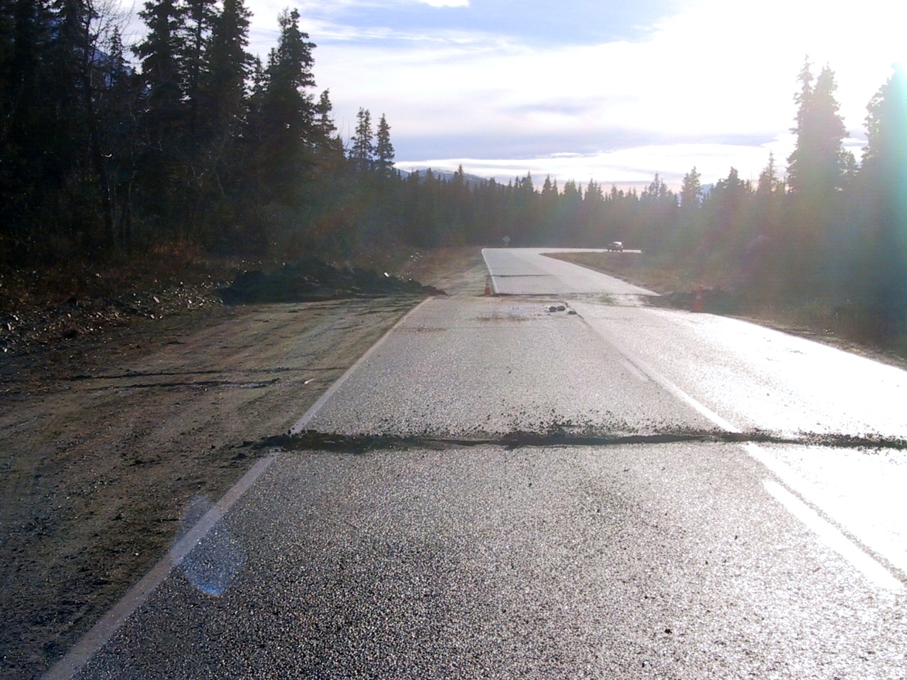
The Denali Fault Earthquake significantly damaged transportation infrastructure in central Alaska. The Richardson Highway crosses the fault, and the earthquake caused a section of the road to shift sideways several feet.
The Trans-Alaska Pipeline System shut down. The Denali Fault Earthquake put its design to the test, the built-in bends shifting on their specially designed skids. There was some minor damage, but the pipeline didn’t spill any oil. This was a major engineering feat, as the Denali Fault rupture ran right under a section of the pipeline.
The earthquake triggered thousands of landslides and rock avalanches in the Alaska Range. Three landslides combined to cover 4 square miles (11 square km) of the Black Rapids glacier with rocky debris.
The Denali Fault Earthquake caused seiches (sloshing) in pools and lakes as far away as Texas and Louisiana. There were reports of triggered seismicity in volcanic and geothermal centers in Washington, California, and Yellowstone, and regional seismicity in Utah.
Because of an earlier earthquake, there were more seismic stations than usual in place, capturing valuable information about this intriguing earthquake. The information gathered from this earthquake went on to become useful for models of how a major earthquake could occur in other large, complex fault systems, such as the San Andreas Fault in California.
The Denali Fault Earthquake in Action
The Denali Fault arcs across most of Alaska, from Southeast through the Interior out to western Alaska. On October 23, just ten days prior to the M7.9 earthquake, the magnitude 6.7 Nenana Mountain Earthquake first pulled scientific attention to the Denali Fault. This earthquake ruptured 25 miles of the Denali Fault west of the M7.9 event. There were no surface expressions of this earthquake. When seismologists realized the Nenana Mountain Earthquake had occurred along the Denali Fault, they rushed to install temporary seismometers, including about 10 installed by the Earthquake Center. A magnitude 6.7 earthquake on a crustal fault that had not shown similar recent activity was a scientific opportunity. As a result, there were many more seismometers in place for the main event on November 3. The Nenana Mountain Earthquake is now considered a foreshock of the larger Denali Fault Earthquake.
After the Denali Fault Earthquake, seismologists added even more stations, including some GPS stations, so that by December there were 26 temporary stations recording aftershocks. These efforts received multiagency support from the Geophysical Institute of the University of Alaska Fairbanks, the Incorporated Research Institutions for Seismology (IRIS) PASSCAL Instrument Center, the U.S. Geological Survey (USGS), the National Science Foundation (NSF), and the University of Wisconsin in Madison.
Just after the Denali Fault Earthquake, a team of geologists took to the air. They found that the earthquake initiated on the Susitna Glacier Thrust Fault. A team of geologists surveyed the total length of the ruptured faults and reported about 13 ft (4 meters) of maximum vertical offsets on the Susitna Glacier Thrust Fault and maximum horizontal offsets of 29 ft (8.8 m) west of the Denali and Totschunda fault junction.
At the Alaska Earthquake Information Center (as it was called at the time), Natalia Ruppert had been an employee for just over a year. Today, she is the center’s senior scientist and project manager. The day of the Denali Fault Earthquake, she rushed into the office to help start analyzing the huge number of aftershocks. The number of recorded earthquakes leapt from fewer than 50 per day before the Nenana Mountain Earthquake to more than 1,000 per day the week after the Denali Fault Earthquake. From then until the end of 2002, the center recorded 20,000 aftershocks. All told, there were about 50,000 aftershocks over the next several years.
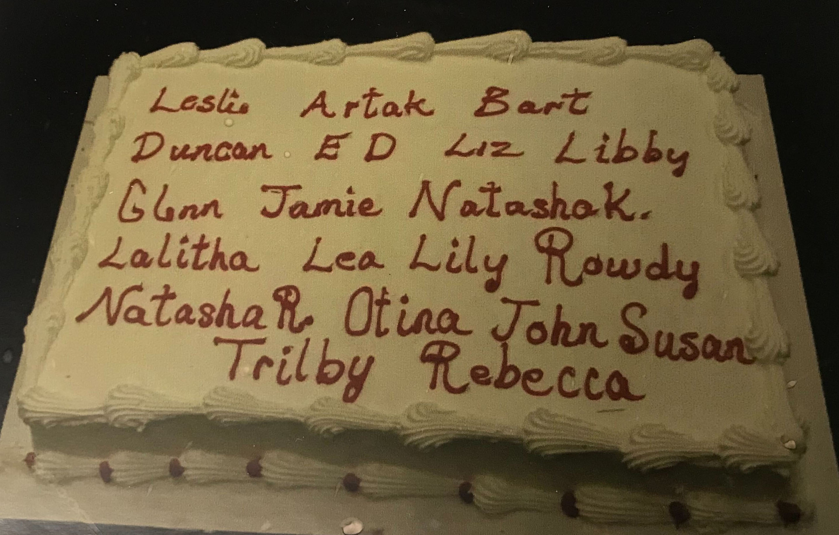
The center had to hire more analysts to deal with the mountain of new earthquake records. Natasha Kozyreva, who continues to be an analyst here at the center, got her start here then. Overall, 20 analysts worked on the Denali Earthquake aftershocks over the course of several years. “It took us a few years to catch up with the aftershock processing,” says Natalia Ruppert. “We had a party after we were finally caught up. We had a cake with all the analyst names on it who contributed to the aftershock processing.”
What We’ve Learned
The Denali Fault Earthquake provided a wealth of new information for researchers to delve into. This earthquake featured prominently as a potential research topic in planning for the Alaska portion of the USArray project. The USArray was a temporary network of seismic stations deployed in a grid across the state from 2014 to 2020. The project’s seismic data is publicly available.
One of the surprises revealed by studying the Denali Fault Earthquake was that there were actually three faults involved: the Susitna Glacier Fault, the Denali Fault, and the Totschunda Fault. Interestingly, the Susitna Glacier fault is a thrust fault, in which one side of the fault moves up and over the other side as a result of compression. The Denali and Totschunda faults, in contrast, are strike-slip faults, in which the two sides of the fault shift past each other sideways.
The way that the Denali Fault earthquake ruptured also proved interesting. When an earthquake occurs, usually the energy spreads out in all directions. In this case, most of the rupture energy sped southeast. The villages on the east side of the rupture along the Tok cutoff road experienced more damage, while Healy to the west didn’t have any damage, even though it was nearly the same distance away. The energy was so strong it reached all the way to the Lower 48, triggering small earthquakes in California and Utah, and influencing geothermal activity in Washington, California, and the Yellowstone region.
In 2002, GPS technology was a new tool in the field of seismology. University of Alaska Fairbanks researchers were in the process of building a GPS instrument network in Alaska. After the Denali Fault Earthquake, they rushed to install GPS instruments to study how the ground shifted and relaxed after the major earthquake. The Denali Fault Earthquake became one of the first earthquakes in Alaska studied using GPS observations.
For several summers after the Denali Fault Earthquake, geologists flocked to Alaska to—literally—dig up evidence of past earthquakes. By digging trenches in the ground, scientists can examine the layers of soil and rock for misalignments that indicate an earthquake happened. By studying the layers, they can also estimate a time frame for when the earthquake occurred, calculating how frequently large earthquakes occur. As a result of these paleoseismology studies along the eastern Totschunda and eastern Denali faults, we now have much better estimates of the slip rates, or movement, of the Denali Fault.
Twenty Years of Influence
Although the Denali Fault Earthquake occurred twenty years ago, it has had far-reaching effects on both earthquake research and the work that the Alaska Earthquake Center does. It led to a partnership between the Alyeska Pipeline Service Company and the Alaska Earthquake Center to build and operate a modern system for monitoring ground motions along the pipeline corridor. This project has been ongoing for over 15 years.
The earthquake generated research in the Denali Fault region, such as geological investigations of the northern foothills of the Alaska Range and dense arrays of hundreds of seismometers to study characteristics of the fault zone. The earthquake also served as an example of ways the USArray could benefit seismic research. When the USArray project finished, the Earthquake Center acquired 96 stations to add to the permanent Alaska network. The effects of the Denali Fault Earthquake may continue to shape the world of seismology, in Alaska and beyond.