


Knowing what an earthquake early warning system is capable of is a critical first step in making it work for Alaska. A recent study by Alaska Earthquake Center scientist Alex Fozkos indicates that such a system could have provided communities near the July 16 magnitude 7.3 earthquake south of Sand Point enough lead time to take action. Earthquake early warning is a system intended to rapidly alert people before strong shaking from a large earthquake arrives at their location.
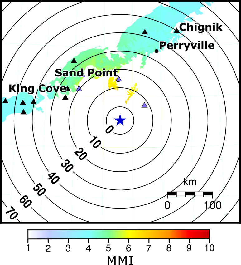
“Individuals in Sand Point could have expected approximately 10 seconds of warning time before shaking increased to its strongest,” said Fozkos. “In King Cove, individuals could have expected a warning of approximately 20 seconds.” Sand Point is 55 miles from the epicenter; King Cove is slightly farther away. The community of Chignik, about 140 miles from the epicenter, would have received about 50 seconds of warning.
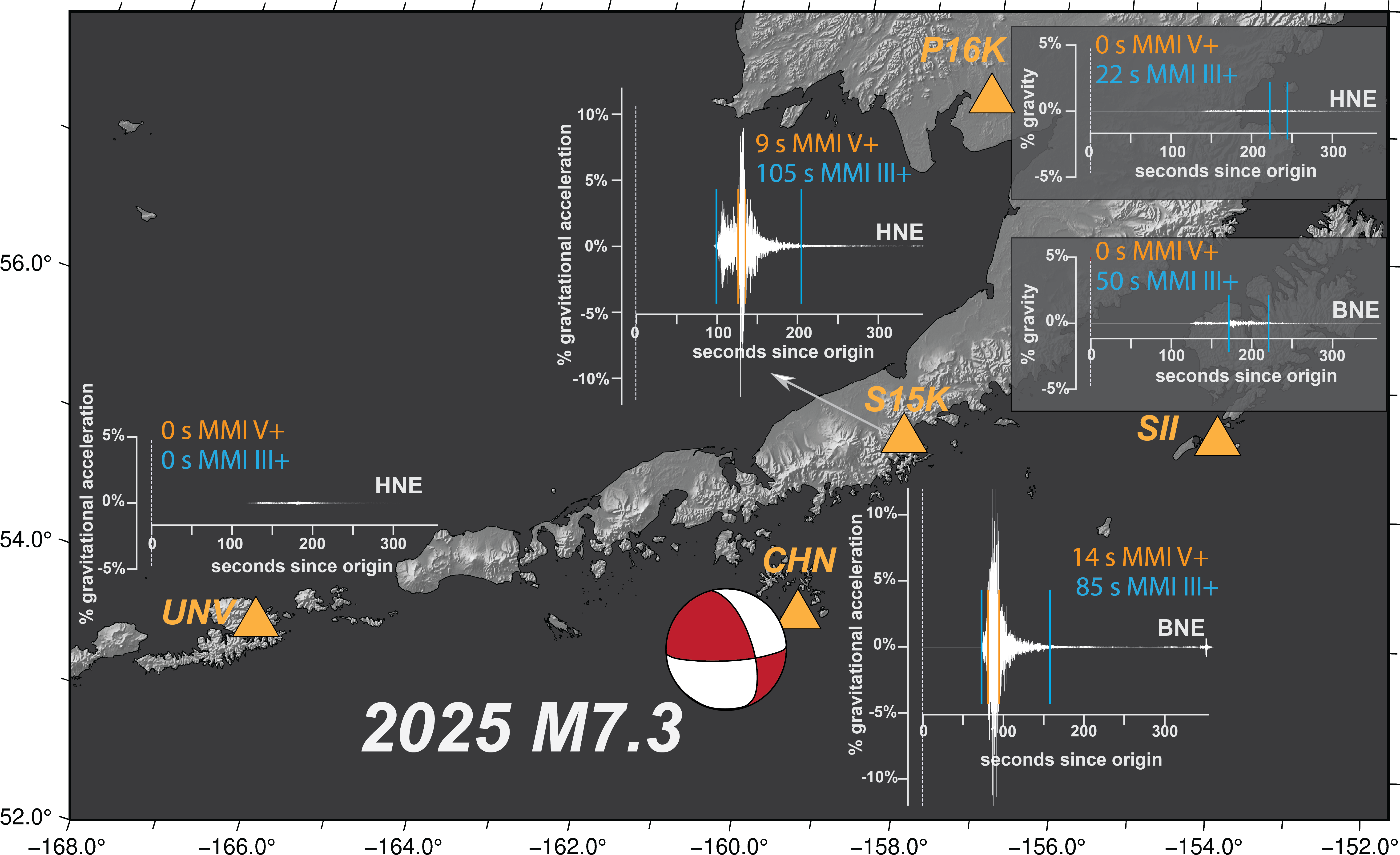
Fozkos generated the time estimates for the Sand Point earthquake using a mathematical model he created to examine earthquake early warning scenarios for Alaska. Results of the modeling were published in the Bulletin of the Seismological Society of America. The Sand Point analysis, which occurred after the paper was submitted and is thus not included, demonstrates the potential of earthquake early warning in Alaska by integrating the actual recorded shaking at Alaska Earthquake Center seismic stations to compute the feasible warning times. It provides a proof of concept for early warning in Alaska.
For the research paper, Fozkos ran numerous warning-time scenarios with varying inputs such as locations, magnitudes, and fault configurations. “This lays the groundwork for showing potential stakeholders how an early warning system could benefit Alaskans and why they should be paying attention,” said Fozkos.
The Sand Point earthquake highlights that using cell-phone-based detection and alert systems is challenging for offshore earthquakes in Alaska. This type of system requires a number of phones close to the earthquake's origin to detect shaking in order to send the alert; however, many of Alaska's southern-margin earthquakes originate offshore, far from large concentrations of cell phones. We have no reports of people receiving a cell-phone-based alert for the M7.3 Sand Point Earthquake.
Earlier in 2025, the Earthquake Center and the U.S. Geological Survey described the first phase of implementing the proposed USGS ShakeAlert warning system in Alaska, a system that currently operates in California, Oregon, and Washington.
Fozkos said Alaska’s tectonic environment is vastly different from that of the West Coast states. “We have crustal earthquakes, we’ve got the deep earthquakes in the slab, we’ve got the interface earthquakes, there’s strike slip, there’s normal faulting.”
“If we’re going to advocate for an earthquake early warning system, then we owe Alaskans the numbers that are directly tied to Alaska and not to California, Oregon and Washington,” he said.
The science and support to establish early warning in Alaska has been in the works for several years. “This research paper’s goal is to make early warning feel real and accessible,” co-author Michael West, director of the Earthquake Center, said. “Alaska has so many types of earthquakes that it can be difficult to explain to people what is possible. This study takes complicated algorithms and technologies and shows what might happen in real-world situations.”
Rather than a prediction, which remains scientifically unfeasible, warning time is the time window between when a person receives an alert or automated safety protocols are initiated, and the arrival of peak ground motion. Earthquakes create different types of waves. The primary, or P wave, is the fastest, but doesn’t cause much shaking. This is the wave that warning systems use to determine where an earthquake occurred, calculate the magnitude, and generate an alert. The slower S wave generates the potentially destructive shaking. Other early warning models look only at the initial arrival of the S wave. However, Fozkos points out in the research paper, the most intense shaking, especially for large earthquakes, may not happen until a few seconds after the S wave’s initial arrival. Giving an alert based on the arrival of the strongest shaking from the S wave adds a little extra warning time. This could mean that someone receives an alert after shaking starts, but the warning still has value in communicating that the shaking is expected to intensify. This is particularly important in Alaska, where people can become accustomed to the common smaller tremors that subside instead of growing into violent shaking from larger earthquakes.
Magnitude and shaking intensity are different beasts. Earthquake magnitude measures the energy released at the earthquake source, while intensity describes the amount of surface ground shaking at a certain location. Magnitude and intensity may not always correspond—for example, a magnitude 7 earthquake at 100 km depth would cause less intense shaking at the surface than a magnitude 7 earthquake at 10 km depth.
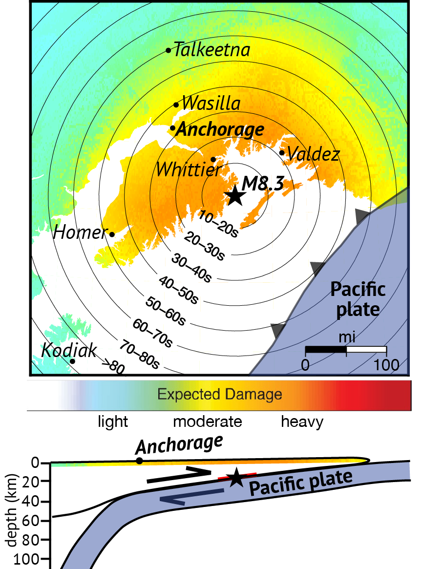
As an example of a realistic earthquake scenario in Alaska, Fozkos reports that for a magnitude 8.3 off the coast, people in Southcentral and Southeast could receive an alert 10-33 seconds before shaking intensities of 7 to 8 reach them. Those intensities can cause moderate to heavy damage to buildings and would be widely felt.
Alerts would be issued quickest in the Southcentral region, where sensor density is highest. “Having more stations in an area means an earthquake can be detected faster and a warning can be issued faster,” Fozkos said.
Overall, the research reports that larger-magnitude and offshore earthquakes would allow for longer warning times.
There is still much work to do to bring earthquake early warning to Alaska. This study helps verify that an early warning system will provide valuable alerting times in the most earthquake-prone parts of the state.