As Interior Alaska remains in a deep freeze, the Alaska Earthquake Center field team is busy planning for the upcoming season. One of the first steps is to review the previous season, so here are some of the successes and highlights from 2025.
Carolyn Parcheta, the Earthquake Center’s field operations manager, said, “The team worked hard to make a lot of important repairs and improvements to our stations throughout the season. We finished with a real feeling of accomplishment.”
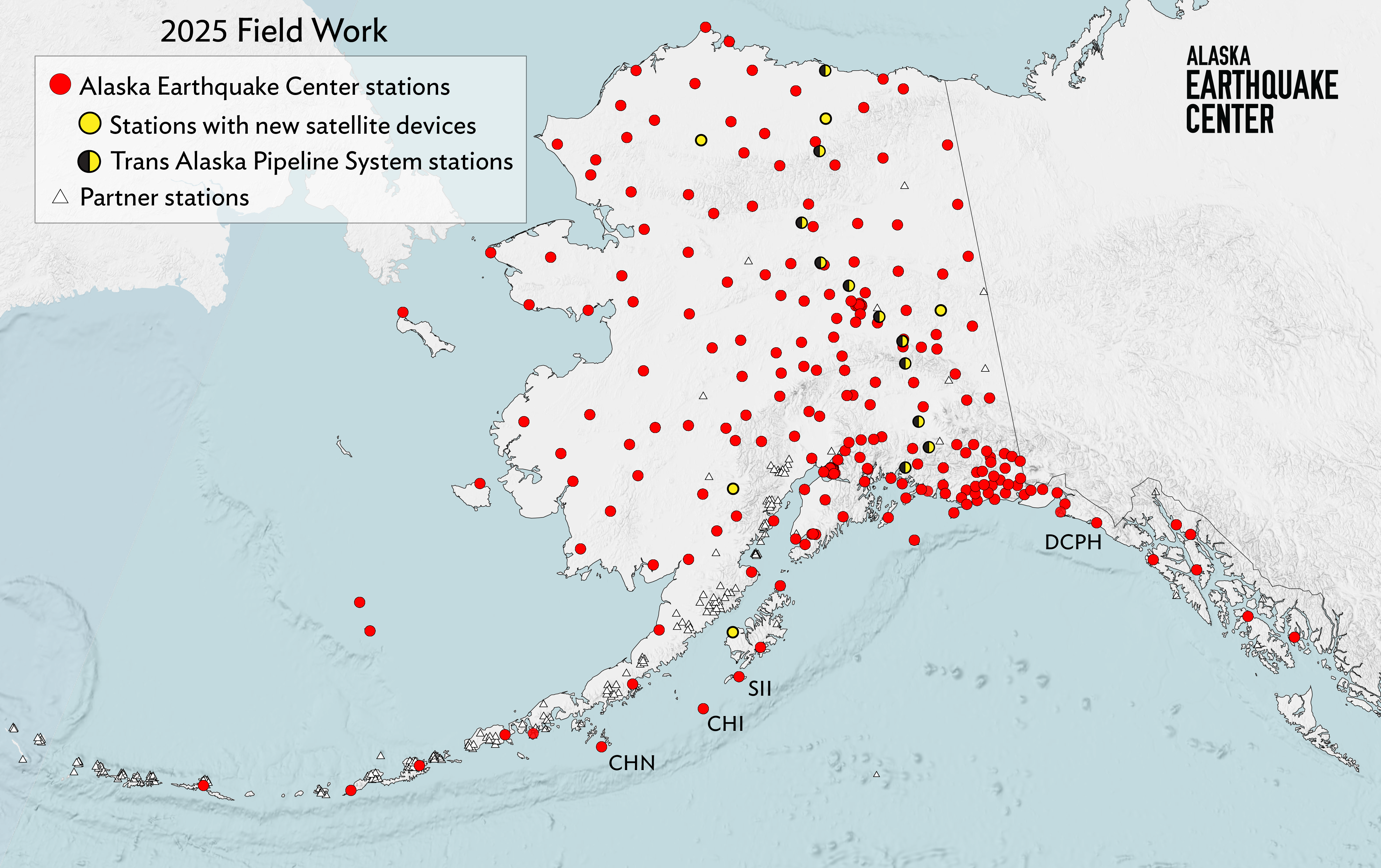
The team installed new satellite communication devices at five stations across the state (Figures 1 and 2) to field-test how they work in various Alaska conditions. If they perform well, we will install more in 2026. The new devices are less expensive than older satellite communication types. They also have a larger bandwidth, which will allow more data transfer in the same amount of time and prevent data gaps. To extend battery life at our northern stations, they will transmit their continuous records in bursts every few hours.
Field engineer Shah Khan led the annual two-week campaign to maintain the seismometers at 11 of the Trans Alaska Pipeline System’s pump stations (Figure 1). The team covered 1,600 miles, upgrading the digitizers at each pump station site. Digitizers collect data from the seismometer, translating it into a digital format that can be transmitted, and also storing it if the communications system is down.
On a trip to Kodiak to replace and realign radios at stations on Sitkinak (SII) (Figure 3) and Chirikof (CHI) Islands (Figure 4), field intern Devin Zigmont put his two-week-old tower climbing training to work ). “As a field intern fresh out of climbing training, the possibility of getting to use my new knowledge on a real site with a real tower was super exciting,” Zigmont said. Both stations are critical to monitoring subduction zone activity.
The field team also brought the Chernabura Island station (CHN) back online. Both CHI and CHN are located offshore of the Alaska Peninsula south of Kodiak, and are crucial for measuring earthquakes near Sand Point. Several magnitude 7+ earthquakes have rattled this region in recent years.
Sometimes Hank the Tank, honorary field team stress tester, takes his job too seriously.
The field team discovered that sites C18K and C19K, near Kotzebue, were destroyed by bears and will need repairs in 2026.
Getting the Deception Hills (DCPH) station (Figure 5) back online for the first time in six years was a big win, as it fills an important network gap. This took several days of timing the weather and good old-fashioned hard labor, “burying our cables so deep the bears will never get to them again,” field engineer Ethan Berkeland reminisced.
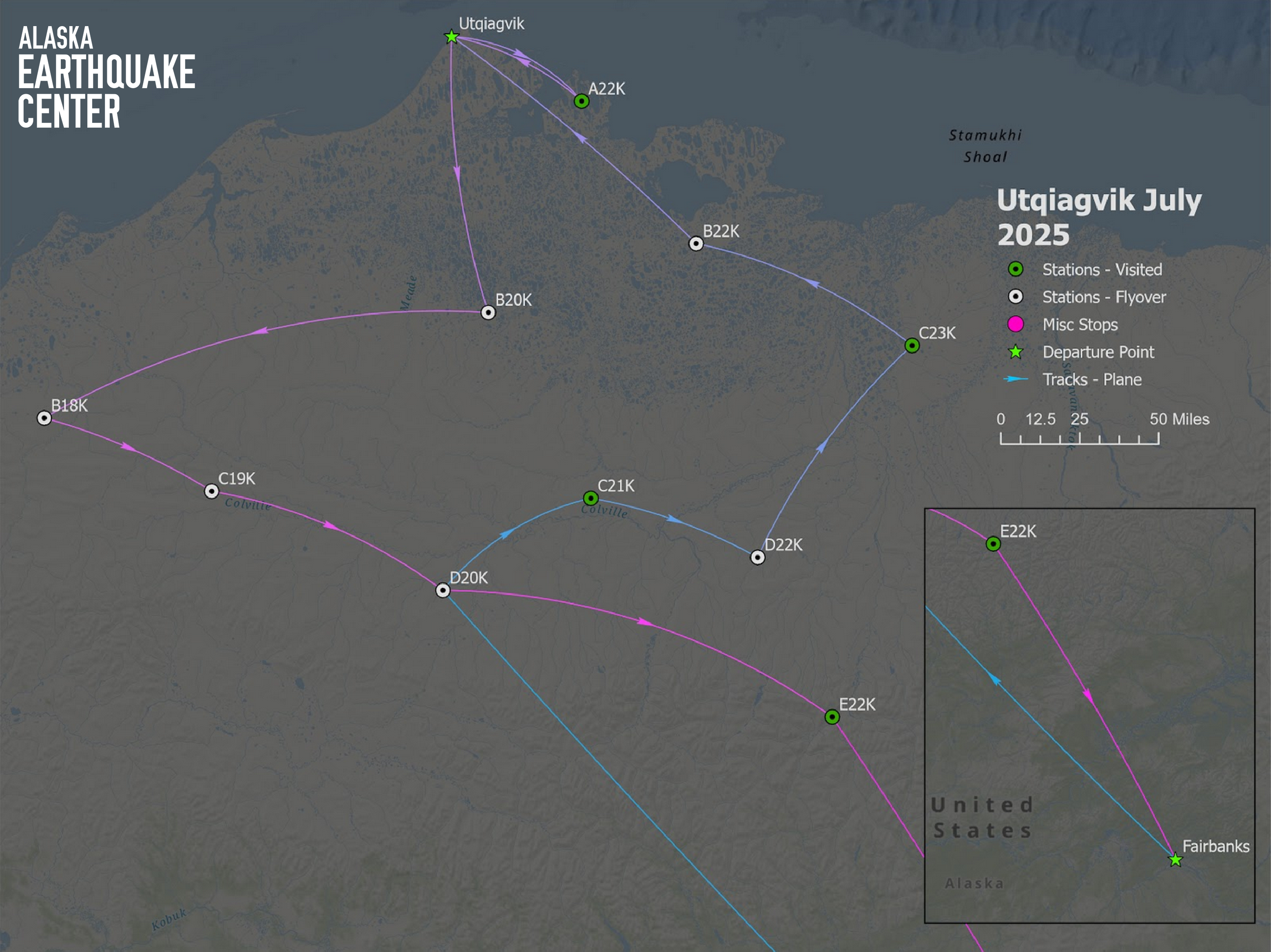
Khan also conducted an airplane scouting mission to see if we can use small planes instead of helicopters to reach remote tundra sites north of the Brooks Range (Figure 6). Using planes could potentially cut transportation costs almost in half. But landing on tundra without an airstrip is tricky at best. “Out of 10 sites, there were two where we landed with no problems,” Khan said. “There was one more that was a very rough landing. The other sites the pilot circled, but he didn’t think it was safe to land.” Parcheta said the field team may try out planes at those sites in the future, but not in the 2026 season.
After all that the field team accomplished in 2025, did they sit around and drink coffee all winter? Nope! They spent it preparing for and planning the 2026 field season—inventorying gear, surplussing outdated equipment, ordering modern supplies, and assessing how well last summer’s fixes held up through our harsh winter. After spring training, they head back out to all corners of Alaska to keep our network humming.