


The July 29, 2025 magnitude 8.8 earthquake off the coast of Kamchatka, Russia, is now tied for the 6th-largest recorded in the world (Fig. 1). It was followed immediately by tsunami alerts that spanned the Pacific, including Alaska. Coming on the heels of a magnitude 7.4 earthquake in the same location on July 20 and a magnitude 7.3 earthquake in Sand Point, Alaska, on July 16, residents of Alaska are likely feeling a state of tsunami hyper-alertness, and full of questions. We intend to answer some of them here.
Tsunamis from across the Pacific
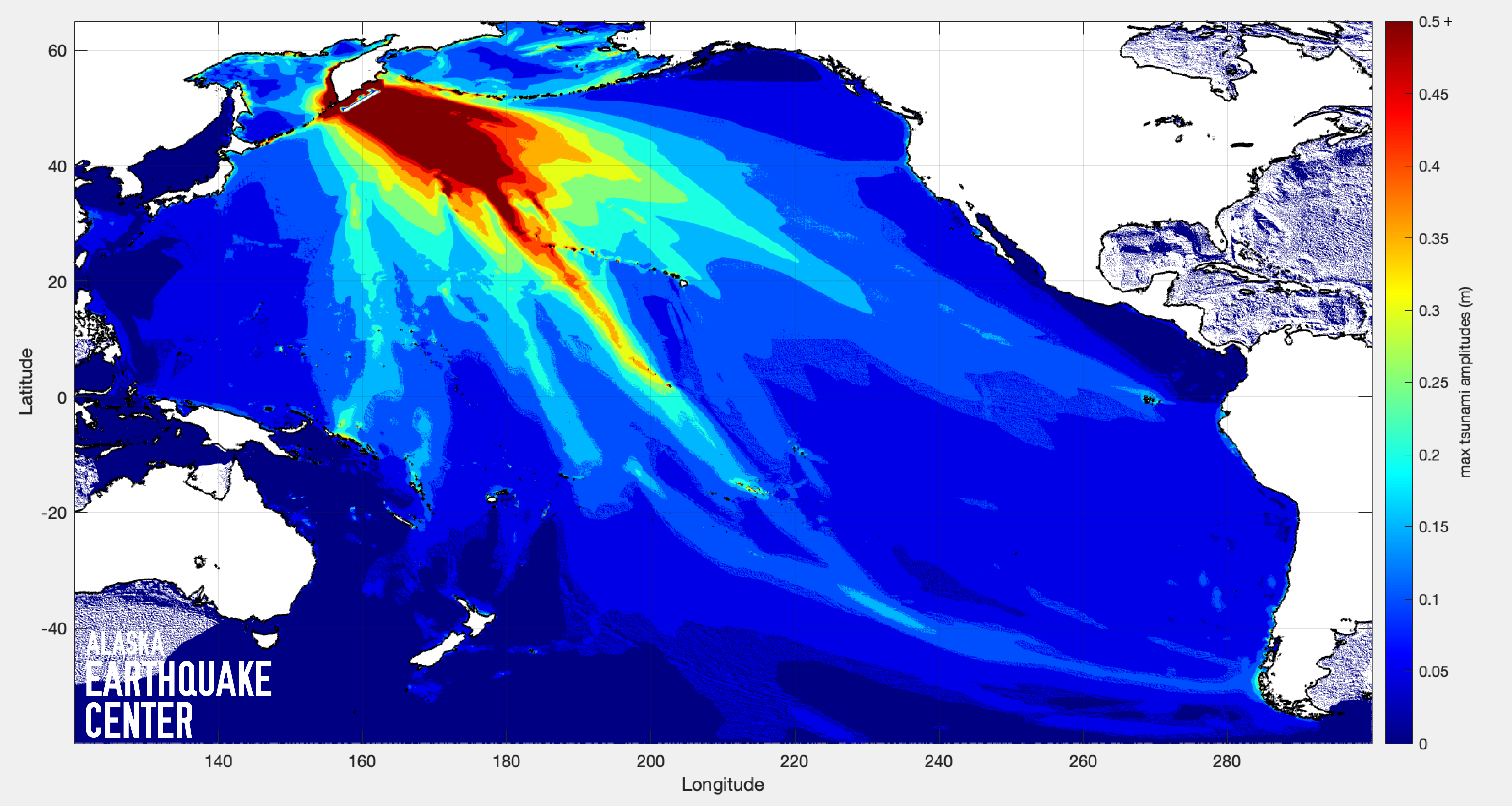
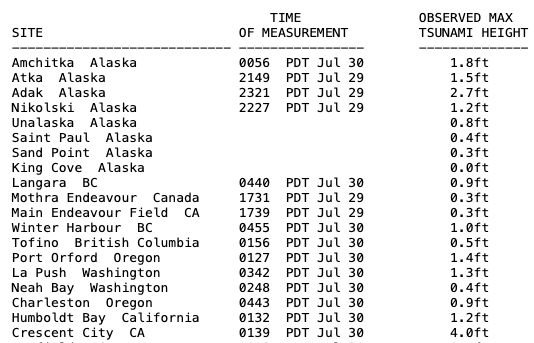
Firstly, kudos to the National Tsunami Warning Center (NTWC) for issuing and updating timely warnings and advisories to Pacific-rim communities of the U.S. Coastal quakes of this size release enormous energy, generating tsunamis that will traverse an ocean. While the highest waves to hit populated areas of Kamchatka were about 20 feet (6 meters), the largest out of a series of waves to hit Alaska, in Adak, was 2.7 feet (0.8 meters) several hours after the earthquake (Figs. 2, 3).
“Even a one-foot wave can be quite dangerous in harbors,” says Alaska Earthquake Center tsunami scientist Elena Troshina. “It can damage boats and boardwalks, because it’s not just the energy of the surface wave, it’s the energy of the entire column of water from the water surface to the bottom of the ocean.”
Additional kudos go to the residents of communities who evacuated to higher ground. As reported by Adak City Manager Breck Craig, residents moved to their safety shelter, and community volunteers returned to town to search for residents who had not appeared at the evacuation site. Hawaii and California residents did likewise, as the tsunami was expected to arrive during high tide. “A tsunami is not just one wave, it's a series of powerful waves,” noted NTWC tsunami warning coordinator Dave Snider. “It's entirely possible that the first wave is not the largest and may not be the last.”
By the following morning, most tsunami warnings had been cancelled, with advisories still in effect for the western Aleutian Islands and the Pribilof Islands, and northern and southern California.
The thrust faulting that generated the Kamchatka Peninsula Earthquake created vertical displacement of land underwater, thereby heaving upward the entire water column above it. This is what sends a tsunami across the ocean, and we have animations of tsunami processes on our website.
To help Alaska residents prepare for the likelihood of tsunamis that come from across the Pacific or from Alaska’s similarly tsunamigenic subduction zone, we have resources for all coastal communities, explaining why tsunamis happen in Alaska, showing potential coastal inundation zones, providing visual and written guidance by community, and more. Troshina visits coastal Alaska communities throughout the year, spreading information and preparedness.
Some may wonder why Alaska’s coast did not experience the same waves seen online in videos from Kamchatka, or even Japan. The reason lies in how waves travel–the ones that move perpendicular to the coastline from where they came are the largest, and land in the path of these will bear the brunt of the wave. Alaska, lying northeast of tsunamis traveling from the western Pacific, receives the edges of the wave at an angle, as seen in this animation of the tsunami generated by a magnitude 7.5 quake from the same location in Kamchatka in 2020.
Earth rings like a bell
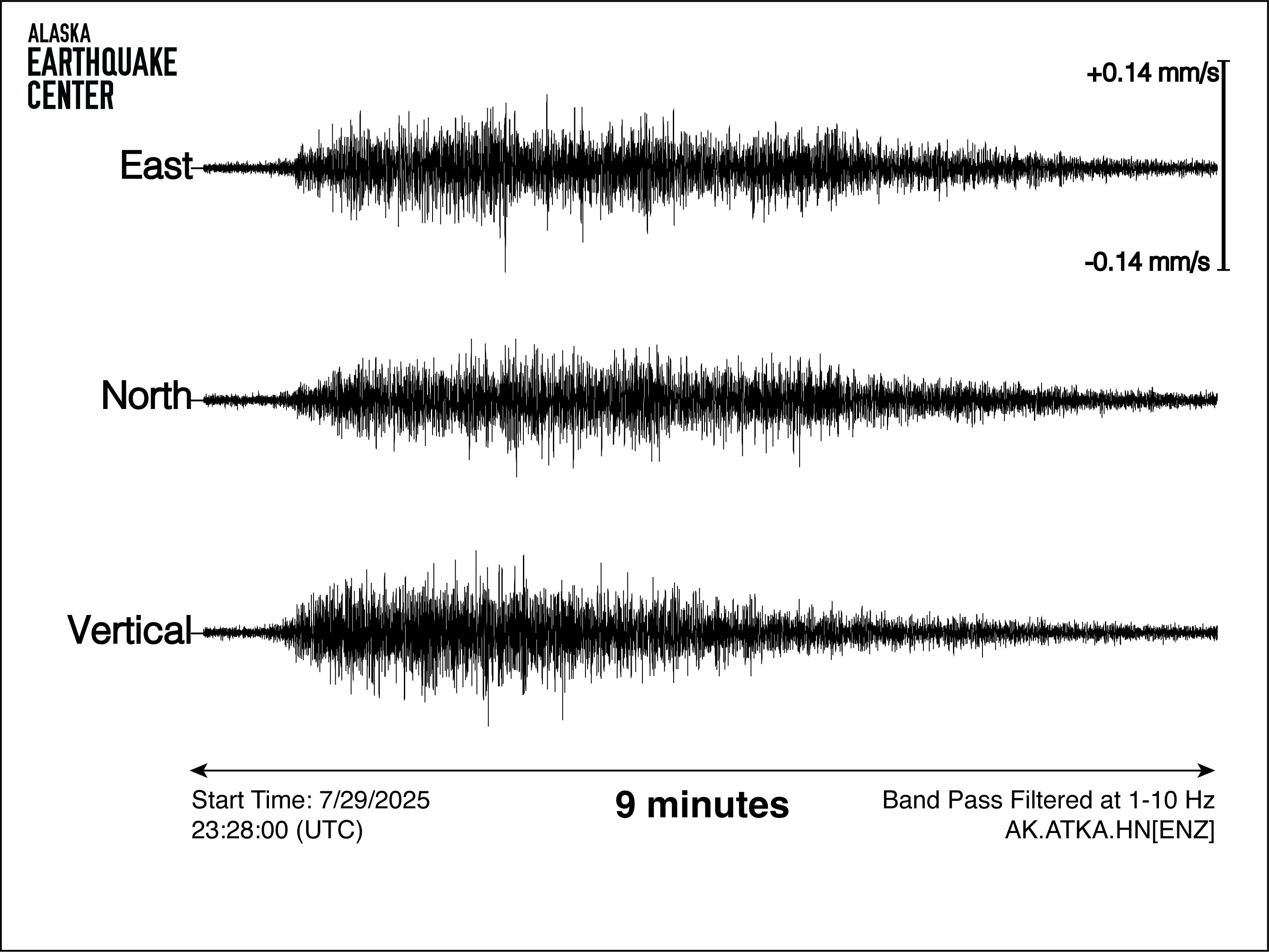
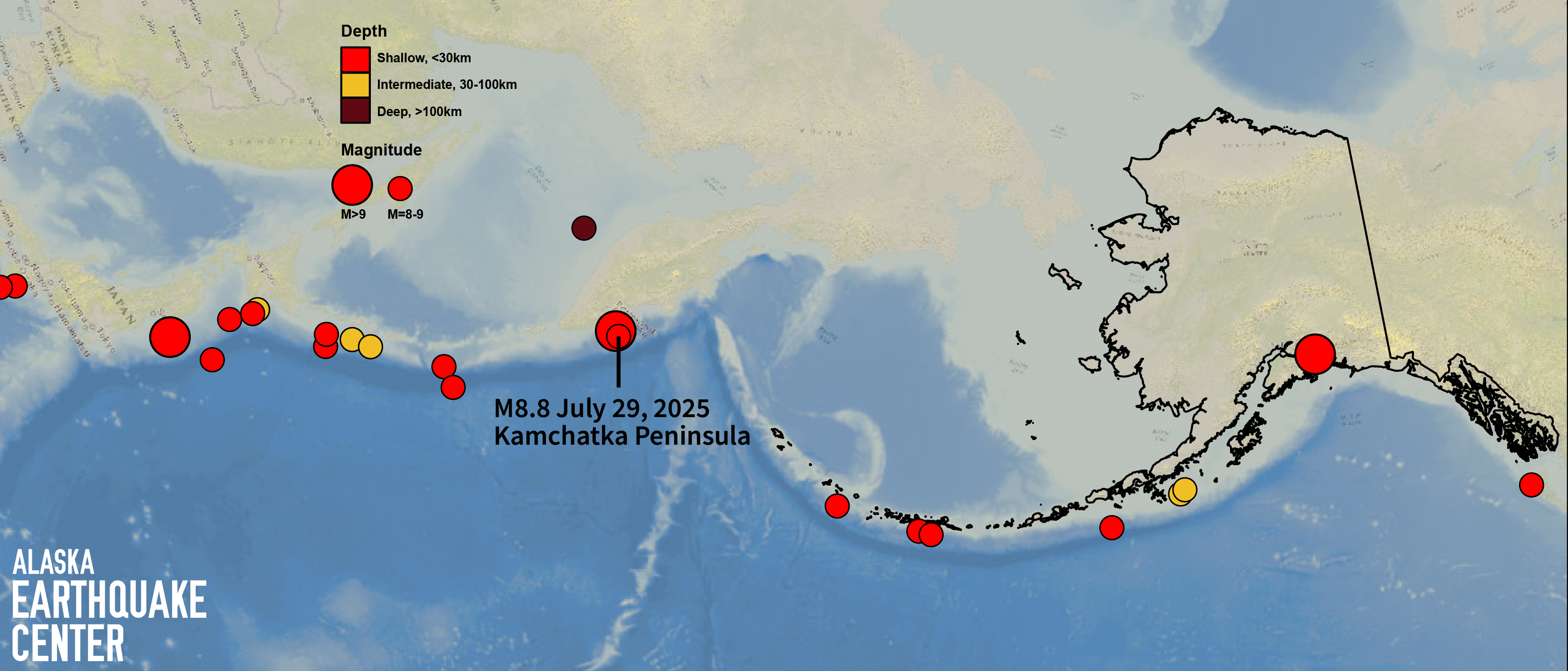
Seismic stations across the globe, including the Earthquake Center’s 250-strong network, picked up the vibrations from the Kamchatka earthquake (Fig. 4). Every earthquake generates seismic waves that travel in all directions. Exceptionally large earthquakes can cause the Earth to oscillate, similar to how a struck bell vibrates. These oscillations are typically very low frequency, can last hours to days, and involve the entire planet. While very slow-moving compared to the regular types of earthquake waves, they criss-cross around Earth multiple times in all directions, essentially causing the planet to “ring” for days. Researchers use these waves to study how energy propagates after large earthquakes and to study the earth’s interior structure—kind of like a CT scan you get at the hospital.
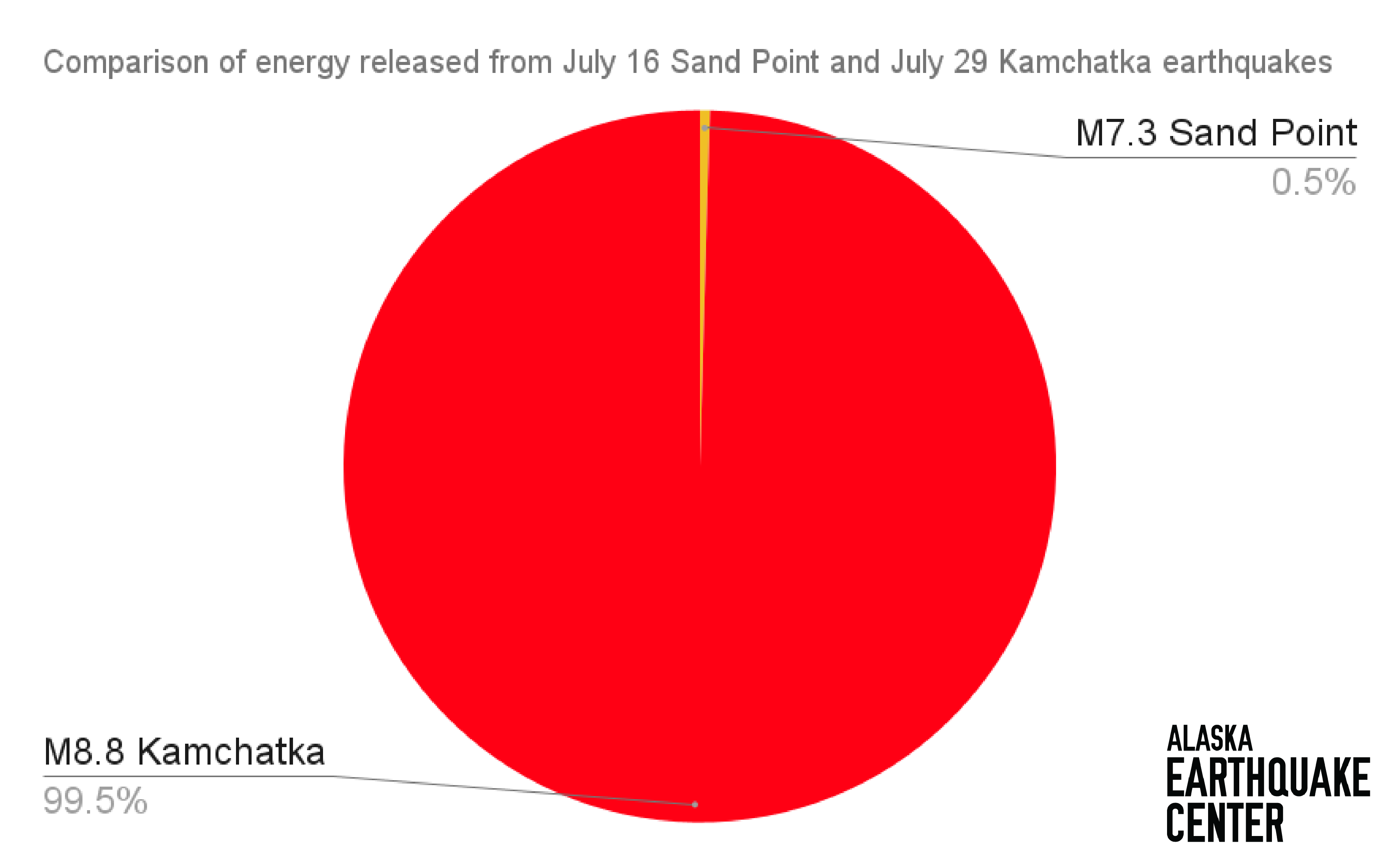
The difference in seismic energy between the July 29 M8.8 Kamchatka event and the July 16 M7.3 Sand Point event is enormous—almost 200 times the energy was released in the larger quake (Fig. 5). This chart, created by the Incorporated Research Institutes for Seismology, compares some earthquakes that have released the largest amounts of energy in history. The M8.8 Kamchatka event falls just under the Japan (2011) and Sumatra (2004) events, with a total energy release close to 10 trillion metric tons of TNT, while the M7.3 Sand Point event’s total energy release is closer to ten billion metric tons of TNT.
Pacific Rim megaquakes
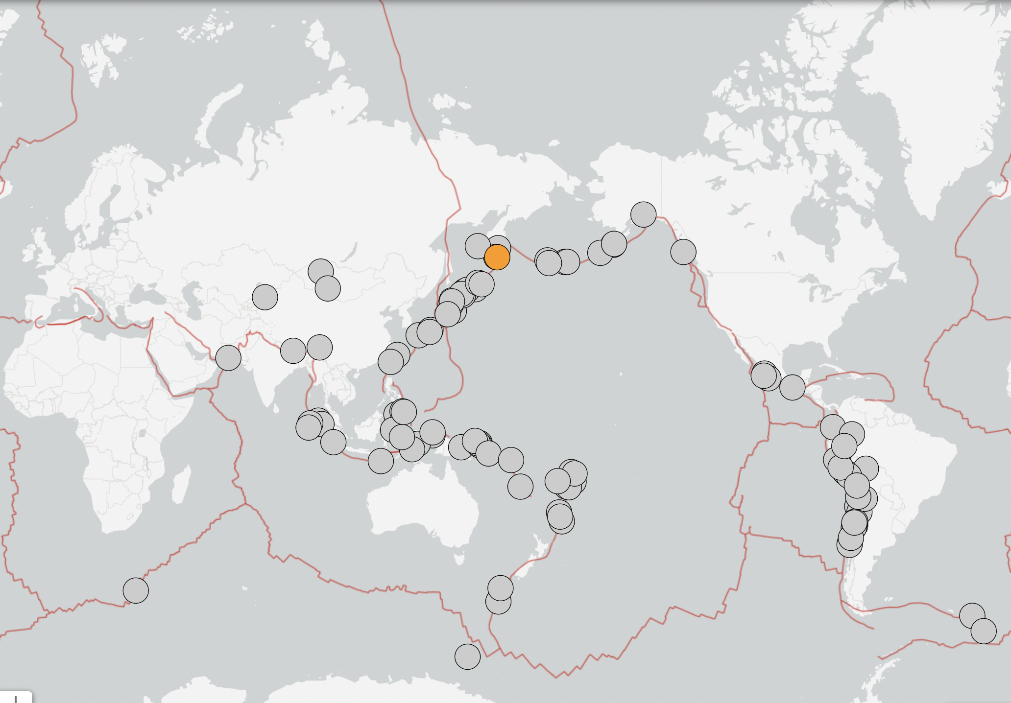
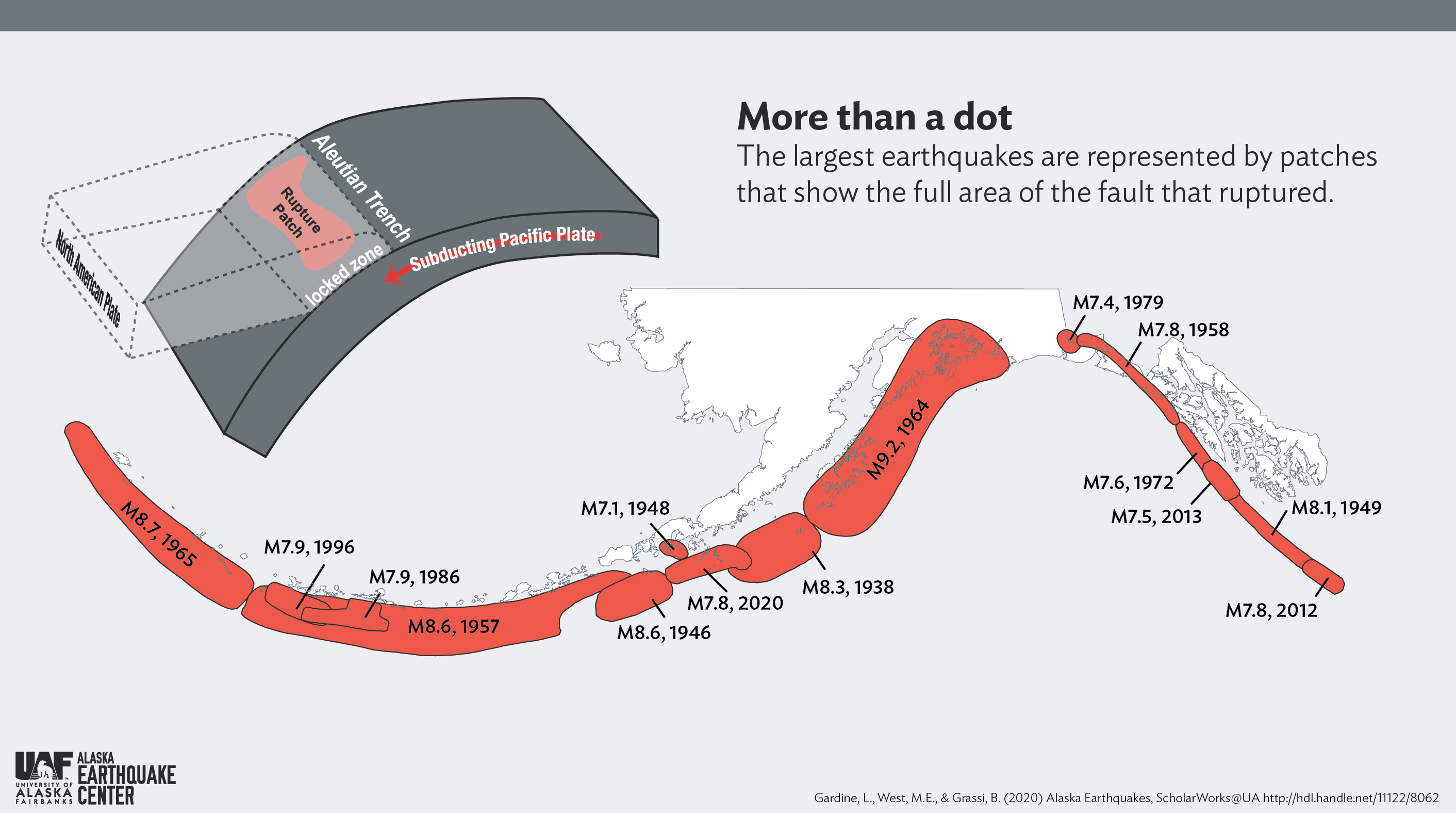
Alaska is no stranger to earthquakes just like yesterday’s. The Pacific Plate grinds inexorably northwestward, moving shallowly under Alaska and the Kamchatka Peninsula and generating some of the world’s largest quakes (Fig. 6). Patches of the Alaska–Aleutian megathrust, the longest subduction zone in the world, have ruptured in no particular sequence over the past century. Since 1938, there have been six earthquakes of magnitudes 8.2 to 9.2 from the farthest west Aleutians to Anchorage (Fig. 7).
"A shallow megathrust is by far the most prevalent way to create such a large earthquake," says Carl Tape, seismology professor at the University of Alaska Fairbanks Geophysical Institute and research affiliate of the Earthquake Center.
The Kamchatka Peninsula Earthquake is (likely) the main shock of a sequence that began on July 20, 2025, with a M5.0. There were about 50 events greater than magnitude 5 in this region before yesterday’s M8.8 event, including the M7.4 on July 20. Aftershocks will continue for years. It is unlikely that these events triggered any increased activity along the Alaska-Aleutian subduction zone, and vice versa.
There is no way to predict when an earthquake will happen, but we know that they happen in Alaska, and that the largest ones happen along our subduction zone. While it is tempting to try to connect earthquakes across an ocean in a predictive manner, there is no evidence that any single quake will trigger another so far away. The last earthquake in the same location as the Kamchatka M8.8 was a magnitude 9.0 in 1952, and there have been 16 earthquakes above magnitude 8.0 along this section of the subduction zone since 1918 (see Tectonic Summary here).
As Alaskans know, such earthquakes occur with similar regularity here, and will continue to shake our state in the future. The level of preparedness demonstrated by our communities yesterday will be of paramount importance into the future.